God's Bridge

Log in to your account

AroundUs is a community-driven map of interesting places, built by curious explorers like you. It grows with every review, story, and photo you share.
Connect to save your favorite spots, contribute locations, and create personalized routes.
Continue with Google
Continue with Apple
Continue with X
Continue with Facebook
Continue with email
By continuing, you accept our Terms and Conditions and our Privacy Policy
Create an account
Add to collection
Map
Suggest a change
Share

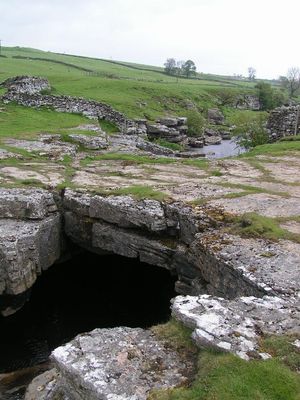
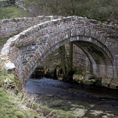
God's Bridge, Natural limestone bridge near Bowes, England

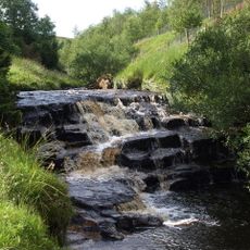
God's Bridge is a natural limestone formation that spans the River Greta, created through erosion and cave development beneath the riverbed. The structure demonstrates how water dissolves and shapes limestone over time in this part of the Pennines.

This bridge formed over millions of years through repeated dissolution and reshaping of limestone beneath water. Its development is part of the longer geological story of the Pennines, where similar processes continue today.

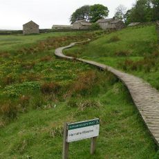
The Pennine Way, a long-distance walking trail, crosses this natural bridge as hikers pass through the region. Visitors experience this formation as part of their journey through the surrounding moorland landscape.

The site is best accessed on foot, particularly when walking the Pennine Way trail, which crosses directly over the bridge. Visitors should wear sturdy footwear and be prepared for changeable weather, as the river area can become wet and slippery.

This bridge is one of the few documented examples in Britain where a river actually pierces through limestone, leaving behind an arch formation. This rare geological feature created a natural crossing that walkers still use today.

GPS coordinates: 54.50920,-2.06722

Latest update: December 14, 2025 11:00

Photos
Around this place
Bowes Castle
United Kingdom

Bowes Castle

3.6 km
Hannah's Meadows
United Kingdom

Hannah's Meadows

6.3 km
Rey Cross
United Kingdom

Rey Cross

5.3 km
Hury Reservoir
United Kingdom

Hury Reservoir

6.7 km
Balderhead Reservoir
United Kingdom

Balderhead Reservoir

6.8 km
Bowes Moor
United Kingdom

Bowes Moor

4 km
Blackton Reservoir
United Kingdom

Blackton Reservoir

6.1 km
Cotherstone Moor
United Kingdom

Cotherstone Moor

4.7 km
Hunder Beck Juniper
United Kingdom

Hunder Beck Juniper

5.8 km
Church of St Giles
United Kingdom

Church of St Giles

3.6 km
The Ancient Unicorn Hotel And Attached Rear Wing (Shown On Os Map As Unicorn House)
United Kingdom

The Ancient Unicorn Hotel And Attached Rear Wing (Shown On Os Map As Unicorn House)

3.8 km
Clove Lodge Farmhouse, Byre/Stables Attached To West And Range Of Sheds Attached To East
United Kingdom

Clove Lodge Farmhouse, Byre/Stables Attached To West And Range Of Sheds Attached To East

5.6 km
Nabb Bridge, 160 Metres West Of Nabb House
United Kingdom

Nabb Bridge, 160 Metres West Of Nabb House

5.2 km
Milestone, 650 Metres West Of Ivy Hall
United Kingdom

Milestone, 650 Metres West Of Ivy Hall

2.7 km
Prospect House And Archway To Right
United Kingdom

Prospect House And Archway To Right

3.5 km
Garden Walls Gate Piers And Gates Adjoining South Front Of Bowes Hall
United Kingdom

Garden Walls Gate Piers And Gates Adjoining South Front Of Bowes Hall

4 km
Bowes Hall
United Kingdom

Bowes Hall

4 km
Cross House And Church View
United Kingdom

Cross House And Church View

3.6 km
Croft House Attached Extension And Sunny Croft
United Kingdom

Croft House Attached Extension And Sunny Croft

3.9 km
Milestone, 35 Metres West Of Milestone House (Shown On Os Map As New House)
United Kingdom

Milestone, 35 Metres West Of Milestone House (Shown On Os Map As New House)

5.2 km
Bowes And District Working Men's Club
United Kingdom

Bowes And District Working Men's Club

3.9 km
Milepost Opposite East End Of Bowes Gate Cottages
United Kingdom

Milepost Opposite East End Of Bowes Gate Cottages

6.8 km
Castle Terrace
United Kingdom

Castle Terrace

3.6 km
1 and 2, the Street
United Kingdom

1 and 2, the Street

3.9 km
The Grove
United Kingdom

The Grove

3.7 km
Milestone, ExYN 2 miles NE of Bowes
United Kingdom

Milestone, ExYN 2 miles NE of Bowes

6.8 km
Milestone, ExYN Huland Quarry, E of entrance
United Kingdom

Milestone, ExYN Huland Quarry, E of entrance

5.9 km
Milestone, ExYN E of Bowes
United Kingdom

Milestone, ExYN E of Bowes

4.2 km
Show the full map
Reviews

Visited this place? Tap the stars to rate it and share your experience / photos with the community! Try now! You can cancel it anytime.

« God's Bridge - Natural limestone bridge near Bowes, England » is provided by Around Us (aroundus.com). Images and texts are derived from Wikimedia project under a Creative Commons license. You are allowed to copy, distribute, and modify copies of this page, under the conditions set by the license, as long as this note is clearly visible.

Discover hidden gems everywhere you go!

From secret cafés to breathtaking viewpoints, skip the crowded tourist spots and find places that match your style. Our app makes it easy with voice search, smart filtering, route optimization, and insider tips from travelers worldwide. Download now for the complete mobile experience.

Around Us App Screenshot

A unique approach to discovering new places

Le Figaro

All the places worth exploring

France Info

A tailor-made excursion in just a few clicks

20 Minutes