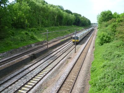
Oakleigh Park Rail Cutting, Nature reserve along railway tracks in London Borough of Barnet, England
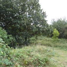
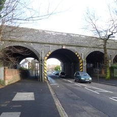
Oakleigh Park Rail Cutting is a nature reserve that runs alongside railway tracks in North London, spanning a substantial area. The site displays two distinct environments: shrubland with thorny vegetation on one bank and mature woodland on the other.
The reserve developed after the railway line was built in the early 1900s, cutting through the landscape and creating new habitats. Over decades, native plants and animals naturally colonized this isolated area along the tracks.
The site serves as a local nature retreat where residents connect with wildlife in the midst of urban London. People use the footbridge to observe how plants and animals have adapted to life alongside the railway.
Access to the reserve is easiest via the pedestrian footbridge that connects two residential streets and provides views into the cutting. Morning visits work best for spotting birds when they are most active and visible.
The site hosts a surprisingly thriving population of goldfinches and other songbirds that flourish in this industrial setting. These birds feed on seeds from wild plants and find shelter in the mature trees, a detail many visitors overlook.
Location: London Borough of Barnet
GPS coordinates: 51.63300,-0.16200
Latest update: December 14, 2025 13:04
Friary Park
1.6 km
Oak Hill Park
725 m
Barnet House, London
990 m
St Mary the Virgin, East Barnet
482 m
Swan Lane Open Space
1.5 km
East Barnet War Memorial
1.1 km
Friern Barnet Parishioners War Memorial
1.3 km
St James the Great, Friern Barnet
1.3 km
Little Grove
1.5 km
All Saints' Church
520 m
St Mary Magdalen Catholic Church, Whetstone
854 m
Barnet Synagogue
1.6 km
Christ Church at Whetstone
662 m
Barfield Allotments Nature Park
723 m
Lawrence Campe Almshouses
1 km
Church of St John
1.1 km
East Barnet Library
1.3 km
Memorial To German First World War Internees, New Southgate Cemetery
1.4 km
Osidge Library
940 m
Clarke Family Monument In St Marys Churchyard
533 m
St James's Primary School
981 m
The Whetstone Outside The Griffin Public House Number 1262
935 m
1264, High Road N20
919 m
1270, High Road N20
924 m
The Limes
964 m
1266 And 1268, High Road N20
926 m
Group Of 6 Tombstones To The Grove Family In St Marys Churchyard
484 m
Longmore Avenue railway bridge
1.3 kmVisited this place? Tap the stars to rate it and share your experience / photos with the community! Try now! You can cancel it anytime.
Discover hidden gems everywhere you go!
From secret cafés to breathtaking viewpoints, skip the crowded tourist spots and find places that match your style. Our app makes it easy with voice search, smart filtering, route optimization, and insider tips from travelers worldwide. Download now for the complete mobile experience.
A unique approach to discovering new places❞
— Le Figaro
All the places worth exploring❞
— France Info
A tailor-made excursion in just a few clicks❞
— 20 Minutes