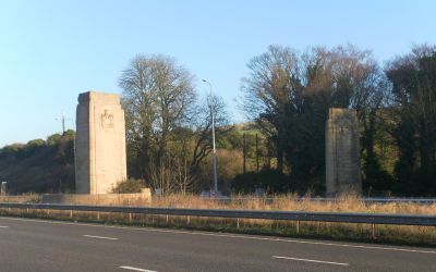
Patcham Pylon, Stone gateway pylons on A23 road in Patcham, England.
Description
Patcham Pylon comprises two limestone towers with concave faces and buttressed corners positioned along the A23 road. These structures form an entrance gateway on the northern side of Brighton and Hove.
History
The towers were built in 1928 when the future King George VI and Queen Elizabeth laid the foundation stones. This royal involvement marked an important moment in the town's history.
Culture
The western tower displays an inscription welcoming visitors and expressing a message of hospitality in stone. This carved greeting reflects how the town wanted to make strangers feel at home.
Practical
Both structures are easily visible from the A23, with one positioned in the central reservation between the lanes. They can be best observed while traveling along the road.
Did you know?
The interiors of the towers contain time capsules with coins, newspaper clippings, and a record book from the foundation stone ceremony. These hidden objects transform them into repositories of local history.
AroundUs brings together thousands of curated places, local tips, and hidden gems, enriched daily by 60,000 contributors worldwide. Discover all places nearby (Brighton and Hove).
Devil's Dyke, Sussex
3.3 km
Chattri
1.3 km
Clayton Windmills
3 km
St John the Baptist's Church, Clayton
3.4 km
Patcham Place
1.9 km
All Saints Church, Patcham
1.9 km
Waterhall Mill
2 km
Church of the Transfiguration, Pyecombe
2 km
Southdown House
2.1 km
Saddlescombe Preceptory
2.1 km
The Parish Church of St John Evangelist
3.4 km
The Church of the Holy Trinity, Poynings
3.1 km
Pyecombe Manor
2.4 km
Patcham Library
2.5 km
Hollingbury Library
3.4 km
Wolstonbury
3.3 km
Dovecote at Patcham Court Farm, 80m north west of All Saints Church
1.8 km
Clayton Tunnel North Portal Tunnel Cottage
3.5 km
106 And 108, Old London Road
2.1 km
Cross dyke and bowl barrow 310m south east of Wolstonbury Camp
2.9 km
A saucer barrow and three bowl barrows on Tegdown Hill
2.2 km
Wolstonbury Camp: a Ram's Hill type enclosure on Wolstonbury Hill and associated later remains
3.3 km
The Old School House
2.1 km
Roman road and 18th century coaching road N of Pyecombe church
2.5 km
Round barrows W of Ditchling Beacon
3.2 km
Redhouse Farmhouse
3.1 km
Romano-British farmstead, field system and trackway on Wolstonbury Hill
3.4 km
Devil's Dyke hillfort
3.2 kmDiscover hidden gems everywhere you go!
From secret cafés to breathtaking viewpoints, skip the crowded tourist spots and find places that match your style. Our app makes it easy with voice search, smart filtering, route optimization, and insider tips from travelers worldwide. Download now for the complete mobile experience.
A unique approach to discovering new places❞
— Le Figaro
All the places worth exploring❞
— France Info
A tailor-made excursion in just a few clicks❞
— 20 Minutes