Church of the Transfiguration, Pyecombe

Log in to your account

AroundUs is a community-driven map of interesting places, built by curious explorers like you. It grows with every review, story, and photo you share.
Connect to save your favorite spots, contribute locations, and create personalized routes.
Continue with Google
Continue with Apple
Continue with X
Continue with Facebook
Continue with email
By continuing, you accept our Terms and Conditions and our Privacy Policy
Create an account

Church of the Transfiguration, Pyecombe

Add to collection
Map
Suggest a change
Share

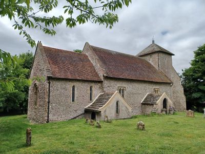
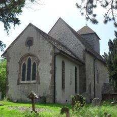
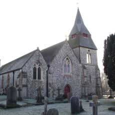
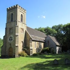
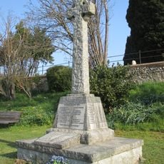
Church of the Transfiguration, Pyecombe, Medieval church in Pyecombe, England.

The Church of the Transfiguration is a medieval church building in Pyecombe featuring 12th-century architecture with a stone structure. A Norman tower stands at its western end, characteristic of churches built during this period.

The church dates back to 1086, when it was recorded in the Domesday Book under the name Pangdean Church. At that time it belonged to St Pancras Priory at Lewes, forming part of the wider church network of the medieval period.

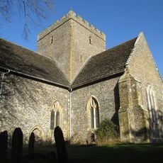
The church has served as the spiritual center for a small rural community for over 800 years. Visitors can see how local people still gather here today for services that connect several nearby villages together.

The church is open to visitors, though it remains an active place of worship with services held regularly. Plan to visit outside service times to have space to walk around and view the building and its architectural features.

The north side features a rare Tapsel gate, one of only six remaining examples in Sussex. This distinctive wooden construction was invented by a local family and remains a remarkable example of medieval craftsmanship.

Location: Pyecombe

Inception: 12 century

Architectural style: medieval architecture

GPS coordinates: 50.89830,-0.16444

Latest update: December 14, 2025 14:21

Photos
Around this place
Chattri
United Kingdom

Chattri

2 km
Danny House
United Kingdom

Danny House

2.4 km
Clayton Windmills
United Kingdom

Clayton Windmills

1.4 km
Patcham Pylon
United Kingdom

Patcham Pylon

2 km
St John the Baptist's Church, Clayton
United Kingdom

St John the Baptist's Church, Clayton

1.6 km
St Cosmas and St Damian Church, Keymer
United Kingdom

St Cosmas and St Damian Church, Keymer

3.5 km
Newtimber Place
United Kingdom

Newtimber Place

2.6 km
Saddlescombe Preceptory
United Kingdom

Saddlescombe Preceptory

2.2 km
The Parish Church of St John Evangelist
United Kingdom

The Parish Church of St John Evangelist

2.2 km
The Church of the Holy Trinity, Poynings
United Kingdom

The Church of the Holy Trinity, Poynings

2.8 km
Pyecombe Manor
United Kingdom

Pyecombe Manor

802 m
Wolstonbury
United Kingdom

Wolstonbury

1.4 km
Dovecote at Patcham Court Farm, 80m north west of All Saints Church
United Kingdom

Dovecote at Patcham Court Farm, 80m north west of All Saints Church

3.6 km
Clayton Tunnel  North Portal  Tunnel Cottage
United Kingdom

Clayton Tunnel North Portal Tunnel Cottage

1.6 km
Keymer War Memorial
United Kingdom

Keymer War Memorial

3.5 km
Hautboys
United Kingdom

Hautboys

2 km
Wolstonbury Camp: a Ram's Hill type enclosure on Wolstonbury Hill and associated later remains
United Kingdom

Wolstonbury Camp: a Ram's Hill type enclosure on Wolstonbury Hill and associated later remains

1.4 km
Cross dyke and bowl barrow 310m south east of Wolstonbury Camp
United Kingdom

Cross dyke and bowl barrow 310m south east of Wolstonbury Camp

1 km
A saucer barrow and three bowl barrows on Tegdown Hill
United Kingdom

A saucer barrow and three bowl barrows on Tegdown Hill

3.2 km
Star House
United Kingdom

Star House

2.4 km
The Old Manor House
United Kingdom

The Old Manor House

3.5 km
The Old School House
United Kingdom

The Old School House

113 m
Little Danny Farmhouse
United Kingdom

Little Danny Farmhouse

2.2 km
Roman road and 18th century coaching road N of Pyecombe church
United Kingdom

Roman road and 18th century coaching road N of Pyecombe church

559 m
Romano-British farmstead, field system and trackway on Wolstonbury Hill
United Kingdom

Romano-British farmstead, field system and trackway on Wolstonbury Hill

1.4 km
Devil's Dyke hillfort
United Kingdom

Devil's Dyke hillfort

3.5 km
Redhouse Farmhouse
United Kingdom

Redhouse Farmhouse

1.6 km
Round barrows W of Ditchling Beacon
United Kingdom

Round barrows W of Ditchling Beacon

2.2 km
Show the full map
Reviews

Visited this place? Tap the stars to rate it and share your experience / photos with the community! Try now! You can cancel it anytime.

« Church of the Transfiguration, Pyecombe - Medieval church in Pyecombe, England » is provided by Around Us (aroundus.com). Images and texts are derived from Wikimedia project under a Creative Commons license. You are allowed to copy, distribute, and modify copies of this page, under the conditions set by the license, as long as this note is clearly visible.

Discover hidden gems everywhere you go!

From secret cafés to breathtaking viewpoints, skip the crowded tourist spots and find places that match your style. Our app makes it easy with voice search, smart filtering, route optimization, and insider tips from travelers worldwide. Download now for the complete mobile experience.

Around Us App Screenshot

A unique approach to discovering new places

Le Figaro

All the places worth exploring

France Info

A tailor-made excursion in just a few clicks

20 Minutes