Enable Location

We need your location to show you interesting places around you

Discover nearby places

Find interesting locations and hidden gems around you

Precise directions

Get accurate directions and distances to places

Your location is never shared with other users. It's only used when you tap the location button.

Newtimber Place

Log in to your account

Start exploring — it's free

Trusted by 63,075 travelers worldwide

Continue with Google
Continue with Apple
or

We will send you a code to connect

By continuing, you accept our Terms and Conditions and our Privacy Policy

Check your inbox

We've sent a pincode in your inbox. Please enter the code below.

Newtimber Place
Discussion Reviews 1 Photos
1.1k Popularity

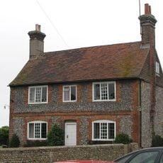
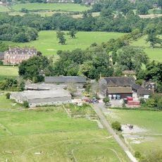
Newtimber Place, Grade I listed building in Mid Sussex, United Kingdom

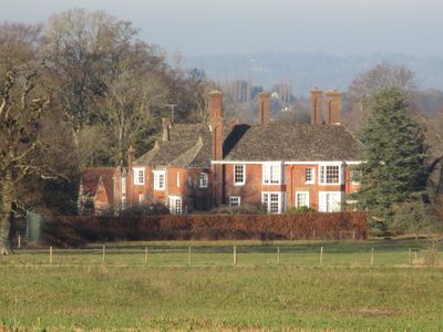
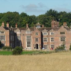
Newtimber Place is a flint and brick house with a Horsham stone roof surrounded by a moat. Dating from the late 1500s with additions in the 1600s, it features a grand staircase from around 1680 and eighteenth-century wall paintings in an Etruscan style within the hall.

Construction likely began with the Bellingham family in the late 1500s and was substantially enlarged in the 1600s. The Newtimber region appears in records from the 900s when King Edgar granted land to Wulfric the thegn, and the territory changed hands among various noble families for centuries.

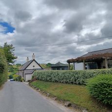
The name Newtimber links to families who shaped the village over centuries through their residence and land ownership. The buildings and grounds show how rural life was organized, with dovecotes and stables still visible today.

Visitors can explore the house only through guided tours lasting about 30 minutes, as self-guided visits are not permitted. The rooms are compact, with solid stone floors and original features, so comfortable footwear is recommended.

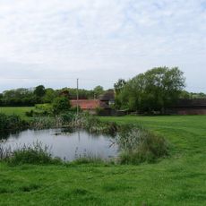
The moat is fed by natural springs and reaches widths up to 50 feet (15 meters) in some areas, making it unusually large for medieval protection. The house sits on a D-shaped island within the moat itself, creating a rare architectural arrangement.

The community of curious travelers

AroundUs brings together thousands of curated places, local tips, and hidden gems, enriched daily by 60,000 contributors worldwide.

Start exploring
Location
GPS coordinates
50.90910,-0.19648
Latest update
February 9, 2026 07:43
Around this place
Devil's Dyke, Sussex
United Kingdom

Devil's Dyke, Sussex

3 km
Danny House
United Kingdom

Danny House

2 km
St John the Baptist's Church, Clayton
United Kingdom

St John the Baptist's Church, Clayton

3 km
The Mansion House
United Kingdom

The Mansion House

3 km
Church of the Transfiguration, Pyecombe
United Kingdom

Church of the Transfiguration, Pyecombe

2.6 km
Beeding Hill to Newtimber Hill
United Kingdom

Beeding Hill to Newtimber Hill

3.1 km
Saddlescombe Preceptory
United Kingdom

Saddlescombe Preceptory

2.3 km
The Parish Church of St John Evangelist
United Kingdom

The Parish Church of St John Evangelist

414 m
The Church of the Holy Trinity, Poynings
United Kingdom

The Church of the Holy Trinity, Poynings

1.7 km
The Parish Church of the Holy Trinity, Hurstpierpoint and Sayers Common
United Kingdom

The Parish Church of the Holy Trinity, Hurstpierpoint and Sayers Common

3 km
The Parish Church of St Bartholomew
United Kingdom

The Parish Church of St Bartholomew

2.7 km
Hurstpierpoint Baptist Church
United Kingdom

Hurstpierpoint Baptist Church

3 km
Pyecombe Manor
United Kingdom

Pyecombe Manor

1.7 km
Wolstonbury
United Kingdom

Wolstonbury

1.5 km
Hurstpierpoint War Memorial
United Kingdom

Hurstpierpoint War Memorial

3 km
Clayton Tunnel  North Portal  Tunnel Cottage
United Kingdom

Clayton Tunnel North Portal Tunnel Cottage

3 km
Star House
United Kingdom

Star House

562 m
Cross dyke and bowl barrow 310m south east of Wolstonbury Camp
United Kingdom

Cross dyke and bowl barrow 310m south east of Wolstonbury Camp

1.7 km
Hautboys
United Kingdom

Hautboys

2.3 km
Washbrook Farmhouse
United Kingdom

Washbrook Farmhouse

2.7 km
The Old School House
United Kingdom

The Old School House

2.6 km
Little Danny Farmhouse
United Kingdom

Little Danny Farmhouse

1.9 km
Gothic House
United Kingdom

Gothic House

3.1 km
Wolstonbury Camp: a Ram's Hill type enclosure on Wolstonbury Hill and associated later remains
United Kingdom

Wolstonbury Camp: a Ram's Hill type enclosure on Wolstonbury Hill and associated later remains

1.5 km
Roman road and 18th century coaching road N of Pyecombe church
United Kingdom

Roman road and 18th century coaching road N of Pyecombe church

2.5 km
Redhouse Farmhouse
United Kingdom

Redhouse Farmhouse

905 m
Devil's Dyke hillfort
United Kingdom

Devil's Dyke hillfort

2.8 km
Romano-British farmstead, field system and trackway on Wolstonbury Hill
United Kingdom

Romano-British farmstead, field system and trackway on Wolstonbury Hill

1.8 km
Show the full map
Reviews
Share your experience

No review yet

Discussions
Start a discussion...

No discussion yet

« Newtimber Place - Grade I listed building in Mid Sussex, United Kingdom » is provided by Around Us (aroundus.com). Images and texts are derived from Wikimedia project under a Creative Commons license. You are allowed to copy, distribute, and modify copies of this page, under the conditions set by the license, as long as this note is clearly visible.

Discover hidden gems everywhere you go!

From secret cafés to breathtaking viewpoints, skip the crowded tourist spots and find places that match your style. Our app makes it easy with voice search, smart filtering, route optimization, and insider tips from travelers worldwide. Download now for the complete mobile experience.

Around Us App Screenshot

A unique approach to discovering new places

Le Figaro

All the places worth exploring

France Info

A tailor-made excursion in just a few clicks

20 Minutes

Around Us
Travel Guide & Maps
Download

Send to your phone

QR Code
1

Open the camera app on your mobile.

2

Point at the QR code with your camera. A notification will appear.

3

Tap the notification to open the link.