Enable Location

We need your location to show you interesting places around you

Discover nearby places

Find interesting locations and hidden gems around you

Precise directions

Get accurate directions and distances to places

Your location is never shared with other users. It's only used when you tap the location button.

The Mansion House

Log in to your account

Start exploring — it's free

Trusted by 61,463 travelers worldwide

Continue with Google
Continue with Apple
or

We will send you a code to connect

By continuing, you accept our Terms and Conditions and our Privacy Policy

Check your inbox

We've sent a pincode in your inbox. Please enter the code below.

The Mansion House

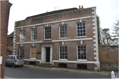
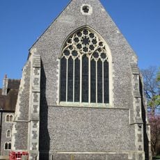
The Mansion House, Grade II* listed building in Hurstpierpoint, England.

Description

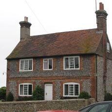
The Mansion House is a multi-period building that fronts directly onto High Street, displaying brick and timber-frame construction on its northern elevation. Its interior contains spacious rooms that have been carefully preserved and updated through modern restoration work.

History

The building retains original sections dating to the mid-1500s and served as home to the prominent Beard family, a line of lawyers, for over 150 years. Later additions in Georgian and Regency styles reflect how the house evolved across centuries.

Culture

The building was home to the Weekes family, who practiced medicine and held extensive land throughout Sussex during the 1800s. Walking past it today, you can sense how this professional lineage shaped the house's importance in the local community.

Practical

The building sits right at street level on High Street, making it easy to view from the pavement as you walk past. Parking and public transport stops nearby make it convenient to visit.

Did you know?

Archaeological work has uncovered multiple building phases within the structure, blending medieval timber framing with later Georgian and Regency additions. This layering of different construction periods makes it a window into changing architectural tastes over centuries.

GPS coordinates
50.93300,-0.17714
Latest update
December 14, 2025 14:25

AroundUs brings together thousands of curated places, local tips, and hidden gems, enriched daily by 60,000 contributors worldwide. Discover all places nearby (Hurstpierpoint and Sayers Common).

Around this place
Hurstpierpoint College
United Kingdom

Hurstpierpoint College

1.4 km
Danny House
United Kingdom

Danny House

1.6 km
St John the Baptist's Church, Clayton
United Kingdom

St John the Baptist's Church, Clayton

3 km
St Cosmas and St Damian Church, Keymer
United Kingdom

St Cosmas and St Damian Church, Keymer

3.5 km
Newtimber Place
United Kingdom

Newtimber Place

3 km
The Parish Church of St John Evangelist
United Kingdom

The Parish Church of St John Evangelist

3.2 km
The Parish Church of the Holy Trinity, Hurstpierpoint and Sayers Common
United Kingdom

The Parish Church of the Holy Trinity, Hurstpierpoint and Sayers Common

247 m
The Parish Church of St Bartholomew
United Kingdom

The Parish Church of St Bartholomew

2.5 km
Church of St George
United Kingdom

Church of St George

482 m
Hurstpierpoint Baptist Church
United Kingdom

Hurstpierpoint Baptist Church

439 m
St Edward the Confessor
United Kingdom

St Edward the Confessor

3.7 km
Lodge And Gateway To The East Of Clayton Priory
United Kingdom

Lodge And Gateway To The East Of Clayton Priory

2.8 km
Pyecombe Manor
United Kingdom

Pyecombe Manor

3.5 km
Wolstonbury
United Kingdom

Wolstonbury

2.6 km
Clayton Tunnel  North Portal  Tunnel Cottage
United Kingdom

Clayton Tunnel North Portal Tunnel Cottage

2.9 km
Hurstpierpoint War Memorial
United Kingdom

Hurstpierpoint War Memorial

201 m
Hurstpierpoint College Chapel
United Kingdom

Hurstpierpoint College Chapel

1.5 km
Keymer War Memorial
United Kingdom

Keymer War Memorial

3.5 km
Little Danny Farmhouse
United Kingdom

Little Danny Farmhouse

1.8 km
Washbrook Farmhouse
United Kingdom

Washbrook Farmhouse

388 m
Cross dyke and bowl barrow 310m south east of Wolstonbury Camp
United Kingdom

Cross dyke and bowl barrow 310m south east of Wolstonbury Camp

3 km
Gothic House
United Kingdom

Gothic House

445 m
The Old Manor House
United Kingdom

The Old Manor House

3.4 km
Wolstonbury Camp: a Ram's Hill type enclosure on Wolstonbury Hill and associated later remains
United Kingdom

Wolstonbury Camp: a Ram's Hill type enclosure on Wolstonbury Hill and associated later remains

2.6 km
Hautboys
United Kingdom

Hautboys

2.1 km
Star House
United Kingdom

Star House

2.5 km
Roman road and 18th century coaching road N of Pyecombe church
United Kingdom

Roman road and 18th century coaching road N of Pyecombe church

3.5 km
Romano-British farmstead, field system and trackway on Wolstonbury Hill
United Kingdom

Romano-British farmstead, field system and trackway on Wolstonbury Hill

2.5 km
Show the full map
« The Mansion House - Grade II* listed building in Hurstpierpoint, England » is provided by Around Us (aroundus.com). Images and texts are derived from Wikimedia project under a Creative Commons license. You are allowed to copy, distribute, and modify copies of this page, under the conditions set by the license, as long as this note is clearly visible.

Discover hidden gems everywhere you go!

From secret cafés to breathtaking viewpoints, skip the crowded tourist spots and find places that match your style. Our app makes it easy with voice search, smart filtering, route optimization, and insider tips from travelers worldwide. Download now for the complete mobile experience.

Around Us App Screenshot

A unique approach to discovering new places

Le Figaro

All the places worth exploring

France Info

A tailor-made excursion in just a few clicks

20 Minutes

Around Us
Travel Guide & Maps
Download

Send to your phone

QR Code
1

Open the camera app on your mobile.

2

Point at the QR code with your camera. A notification will appear.

3

Tap the notification to open the link.