Piercebridge Roman Bridge
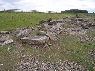
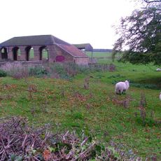
Piercebridge Roman Bridge, Roman bridge ruins near High Coniscliffe, England.
Piercebridge Roman Bridge consists of stone remains featuring five massive piers that once stretched across the river. The partially preserved supports show evidence of wooden fixture holes used in the bridge's original construction.
The bridge was constructed around 90 AD to carry Dere Street across the river, linking important Roman military routes. Its remains were uncovered in 1972 during gravel extraction work at the site.
This location served as a vital crossing point for Roman military movement and trade traffic. The remains tell the story of how armies and merchants relied on this infrastructure to connect distant regions.
The remains sit about 90 meters south of where the river now flows, so you will not find them surrounded by water. Walking around the site allows you to examine the stone structures from different angles and understand how the ancient crossing worked.
Some archaeologists believe the structure may have functioned as a navigation dam, suggesting an elaborate Roman river transport network. Archaeological finds from the site provide evidence of how extensively this waterway was used for moving goods and military supplies.
Location: High Coniscliffe
Website: https://english-heritage.org.uk/visit/places/piercebridge-roman-bridge
GPS coordinates: 54.53600,-1.67100
Latest update: December 12, 2025 09:03
Walworth Castle
2.8 km
Piercebridge Roman Fort
326 m
Ulnaby
2.4 km
Thornton Hall
2.8 km
Raby Hunt Inn
3.6 km
Piercebridge Roman Fort
318 m
Church of All Saints
2.5 km
Church of St Edwin
1.3 km
Church of St Mary
355 m
Dovecote And Single Storey Range To South Of Parkside Farmhouse
3.3 km
Haybarn And Attached Shed South Of Parkside Farmhouse
3.2 km
George Hotel
263 m
Carlbury Bridge
291 m
The Bridge House
333 m
Milepost South Of Carlbury Hall
234 m
Ice House To East Of Quarry End
3.7 km
Piercebridge Bridge
332 m
Ivy House
386 m
Milepost In Front Of Number 12 (Cedar Ridge)
3.3 km
Milepost At High Coniscliffe Bridge
1.7 km
Medieval Chapel Ruins On Roman Foundations In Rear Garden Of Bath House, Tees View
354 m
The Old Hall
1.2 km
Milestone, 110 Metres South Of Greystone Hall
3 km
Wall, Gate Piers, Overthrow And Lantern To West Of Church Of St Mary
371 m
2, The Green
417 m
Threshing Barn And Gin Gang East Of Walworth Grange Farmhouse
3.8 km
Round barrow 340m east of Cliffe Hall known as Betty Watson's Hill
544 m
28, The Green
360 mVisited this place? Tap the stars to rate it and share your experience / photos with the community! Try now! You can cancel it anytime.
Discover hidden gems everywhere you go!
From secret cafés to breathtaking viewpoints, skip the crowded tourist spots and find places that match your style. Our app makes it easy with voice search, smart filtering, route optimization, and insider tips from travelers worldwide. Download now for the complete mobile experience.
A unique approach to discovering new places❞
— Le Figaro
All the places worth exploring❞
— France Info
A tailor-made excursion in just a few clicks❞
— 20 Minutes