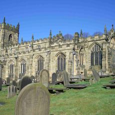
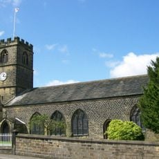
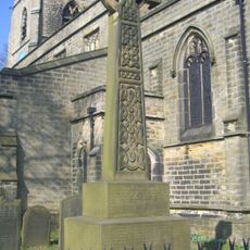
St Mary's Church, Bolsterstone, Anglican church in Bolsterstone Village Square, England
St Mary's Church, Bolsterstone is a stone building in a village in England featuring a bell tower and colored glass windows. These windows illuminate the interior and create a reverent space for worship and contemplation.
The first religious structure at this site dates to 1412 and began as a private chapel serving a specific purpose. Over the centuries it evolved into the building that stands today.
The church serves as a meeting place for locals who gather for morning sessions and refreshments, where residents connect over shared traditions and faith-based practices.
The building sits on the Village Square in Bolsterstone and is easy to locate when exploring the area. Weekday mornings are a good time to visit when community activities take place.
Inside is a commemorative glass window installed in 1997 that honors those from a local singing group affected by a tragic accident. This artwork serves as a touching reminder of a specific chapter in the village's past.
Location: Stocksbridge
GPS coordinates: 53.46740,-1.59360
Latest update: December 14, 2025 16:44
Church of St Nicholas, Bradfield
4.3 km
Onesacre Hall
4.3 km
Wortley Top Forge
3.9 km
Wortley Top Forge
3.8 km
Church of St Leonard
4.5 km
Milepost Approximately 20 Metres East Of Junction With Park Drive
1.9 km
Guide Pillar At Junction With Peg Folly On South Side Of Junction
2.4 km
Guidepillar At Junction With Lumb Lane, Onesmoor Bottom And Onesacre Road On West Side Of Junction
3.5 km
Stocksbridge Clock Tower
1.6 km
Guide Pillar At Junction With Brightolmlee Road And Peat Pits Lane On South Side Of Junction
3 km
Bolsterstone War Memorial
23 m
Unsliven Bridge, Stocksbridge
2.9 km
Guide Pillar At Junction With Brightholmlee Road On South West Side Of Junction
2.6 km
Huthwaite Hall
3.9 km
Glen Howe Packhorse Bridge, Approximately 100 Metres Upstream Of Cottage
3.3 km
Guide Pillar At Junction With Walker Edge, Green Lane And White Lee Lane, On South West Side Of Junction
1.9 km
Milestone Approximately 400 Metres West Of Junction With Underbank Lane
3.2 km
Guide Pillar At Junction With Onesmoor Road On West Side Of Junction
2.6 km
Milestone On North East Side Of Junction With Bank Lane
4.1 km
Guide Pillar At Junction With Peat Pits Lane, On North East Side Of Junction
3.4 km
Milepost Opposite Number 220 Approximately 200 Metres North West Of Junction With Haywood Lane
1.8 km
Guide Post At Junction With Dyson Cote Lane
3.8 km
Guide Pillar At Handsome Cross On North Side Of Road
2.9 km
Guide Pillar At Road Junction South Of Langley Brook On North West Side Of Junction
2.9 km
Milepost At Conjunction With Langsett Road North
4 km
Guide Pillar At Junction With Mortimer Road On South Side Of Junction
3.3 km
Rural Cottage
4.4 km
Church Cottage Vestry Cottage Wesley Cottage
4.3 kmVisited this place? Tap the stars to rate it and share your experience / photos with the community! Try now! You can cancel it anytime.
Discover hidden gems everywhere you go!
From secret cafés to breathtaking viewpoints, skip the crowded tourist spots and find places that match your style. Our app makes it easy with voice search, smart filtering, route optimization, and insider tips from travelers worldwide. Download now for the complete mobile experience.
A unique approach to discovering new places❞
— Le Figaro
All the places worth exploring❞
— France Info
A tailor-made excursion in just a few clicks❞
— 20 Minutes