St Mary's Church, Dodleston, Anglican church in Dodleston, United Kingdom
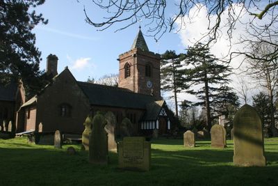
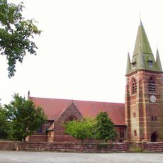
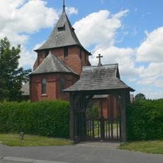
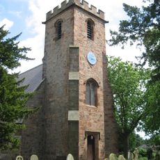
St Mary's Church is an Anglican church building in Dodleston constructed with red sandstone walls and topped with a grey slate roof. The tower rises prominently with diagonal buttresses supporting its structure and a spire set above a crenellated parapet.
The tower's base originates from the early 16th century and represents the oldest part of the building. Architect John Douglas carried out a major reconstruction of the remaining structure in 1870, employing the Perpendicular style throughout.
The church carries a name rooted in local devotion and serves as a focal point for village life. Visitors can observe the royal coat of arms displayed on the west wall and medieval stone work that reflect the site's long history.
The church sits within the village of Dodleston and is accessible on foot. Visitors should expect the building to be situated in a residential area, so quiet behavior and respectful entry are needed.
Marks from musket fire remain visible on the north side of the tower, left over from the English Civil War. These physical scars show directly how this location was caught up in that turbulent period.
Location: Dodleston
Inception: 1870
Architects: John Douglas
Architectural style: Gothic Revival
Website: http://achurchnearyou.com/dodleston-st-mary
GPS coordinates: 53.14160,-2.95540
Latest update: December 14, 2025 18:04
Broughton Hall
3.7 km
Pulford Castle
2.6 km
Christ Church, Rossett
3.8 km
St Mary's Church, Pulford
2.5 km
Belgrave Lodge
2.5 km
Dodleston Castle
86 m
Lower Kinnerton Hall
2.4 km
All Saints Church, Higher Kinnerton
3.3 km
Presbyterian Chapel, Rossett
3.8 km
Green Farmhouse, Poulton
3.9 km
St Mary's Church
3.6 km
Red Lion Inn
175 m
Pulford War Memorial
2.5 km
Lychgate canopy and wing walls, St Mary's Churchyard
40 m
Meifod
3.9 km
Rossett Mill
3.9 km
Old School House
1.8 km
Broadhey Farm Farmhouse
2.2 km
Lodge and forecourt wall north of former Pulford Approach to Eaton Park
2.5 km
Gell Farm Farmhouse
2 km
Dodleston Hall
582 m
Former central farm building associated with Moor End Farm
1.5 km
Farm buildings at Meadow House Farm
945 m
Broadhey Farm Buildings
2.2 km
Dovecote at Dodleston Hall
606 m
Dodleston Lane Farmhouse
797 m
Milepost, SE of Belgrave Bridge, A483 roundabout
2.8 km
Milepost, Main Street, 20m N of jct with Old Lane
2.4 kmVisited this place? Tap the stars to rate it and share your experience / photos with the community! Try now! You can cancel it anytime.
Discover hidden gems everywhere you go!
From secret cafés to breathtaking viewpoints, skip the crowded tourist spots and find places that match your style. Our app makes it easy with voice search, smart filtering, route optimization, and insider tips from travelers worldwide. Download now for the complete mobile experience.
A unique approach to discovering new places❞
— Le Figaro
All the places worth exploring❞
— France Info
A tailor-made excursion in just a few clicks❞
— 20 Minutes