Spout of Garnock, Waterfall in North Ayrshire, Scotland.
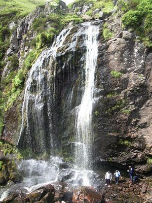
Spout of Garnock is a waterfall in Clyde Muirshiel Regional Park, North Ayrshire, dropping 20 meters and ranking among the highest falls in the region. The water cascades over rock faces, creating a focal point within the moorland landscape that visitors encounter along the walking routes.
Mining activity shaped the area in earlier times, and in 1833 a significant collapse occurred when the riverbed near the falls sank into mining workings, triggering extensive flooding. This event left a mark on the landscape and influenced how the region developed afterward.
Local people value this cascade as a symbol of the natural beauty that defines the region, and its presence shapes how walkers experience the surrounding moorland. The falls have become part of how residents and visitors understand the wild character of this corner of Scotland.
Access is gained through a walking route starting from the car park at Milton Road in Kilbirnie, passing through moorland terrain to reach the falls. Sturdy footwear and weather-appropriate gear are important, as paths can be uneven and often muddy depending on recent rain.
Contrary to long-held local belief, this cascade does not mark the river's starting point, as the source lies around 1.5 kilometers further upstream. This misconception reveals how the dramatic appearance of falling water can create false impressions about a river's true origin.
The community of curious travelers
AroundUs brings together thousands of curated places, local tips, and hidden gems, enriched daily by 60,000 contributors worldwide.