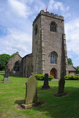
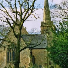
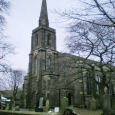
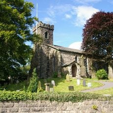
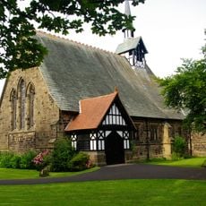
St Wilfrid's Church, Ribchester, Grade I listed Anglican church in Ribchester, England
St Wilfrid's Church is a stone building with Gothic features in Ribchester that developed across multiple construction phases. The structure displays a three-stage tower, pointed arches, stone pillars, and a roof of slate tiles covering the main interior space.
Construction of the building began in the 13th century as the first phase of a long building history. A chapel, entrance porch, and west tower were added during the 14th and 15th centuries, expanding the original structure.
The church is named after St Wilfrid, an important early missionary to northern England. Visitors can observe the craftsmanship of different eras visible in the fittings, pews, and decorative details throughout the building.
The location remains accessible through regular worship services and invites visitors to explore its architectural features. The churchyard contains a listed sundial dating to the 18th century that visitors can view while strolling the grounds.
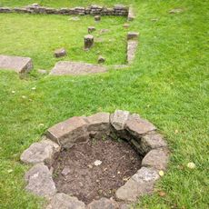
The church sits precisely where the main structures of the Roman fort Bremetennacum once stood in ancient times. This unexpected overlap between medieval architecture and Roman settlement history makes the location notable for those interested in layered histories.
Location: Ribchester
Inception: 13 century
Website: http://saintwilfrids.org.uk
GPS coordinates: 53.81030,-2.53320
Latest update: December 13, 2025 17:04
Bremetennacum
55 m
Punch Bowl Inn
3.7 km
Alston Hall
4.3 km
Stonyhurst Observatory
2.5 km
St Saviour's Church, Stydd
1 km
Ribchester Bridge
1.4 km
St Leonard's Church, Balderstone
3.3 km
St Mary's Church, Mellor
4.2 km
Almshouses
881 m
White Bull Hotel And Former Stable Adjoining To The North
196 m
Church of St John Evangelist
4.3 km
The Bayley Arms
4.7 km
Church of St Mary With Presbytery
3.2 km
Church of St Peter and St Paul
856 m
Roman Baths Ribchester
211 m
Dutton Hall
2.2 km
Shireburn Arms Hotel And Stable Block Adjoining At Right Angles To The East
4.5 km
Osbaldeston Hall
831 m
Oxendale Hall
1.6 km
St Peter's Church, Salesbury
3.8 km
Oaks Bar
2.5 km
Tunnel Portal In The John Smith Playing Field
4.7 km
Boer War Memorial on west side of the Green
4.6 km
Greengore
4.6 km
Huntingdon Hall
4 km
Milestone, Mellor Brook
4.7 km
Milestone, Longsight Road at SD6669833285
2.4 km
Milestone, Longsight Road at SD6955934447
4.6 kmVisited this place? Tap the stars to rate it and share your experience / photos with the community! Try now! You can cancel it anytime.
Discover hidden gems everywhere you go!
From secret cafés to breathtaking viewpoints, skip the crowded tourist spots and find places that match your style. Our app makes it easy with voice search, smart filtering, route optimization, and insider tips from travelers worldwide. Download now for the complete mobile experience.
A unique approach to discovering new places❞
— Le Figaro
All the places worth exploring❞
— France Info
A tailor-made excursion in just a few clicks❞
— 20 Minutes