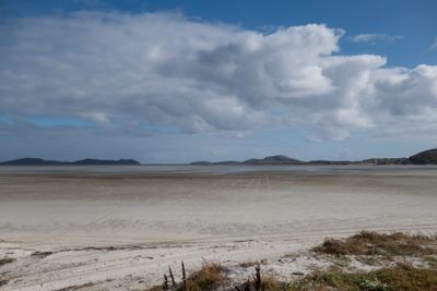
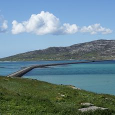
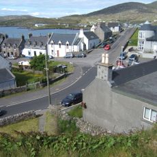
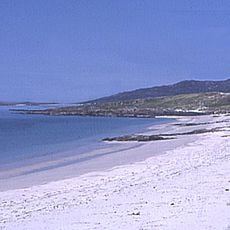
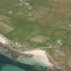
Tràigh Mhòr, Beach and airport runway in Isle of Barra, Scotland
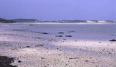
Tràigh Mhòr is a wide beach covered in white shell sand on the northern tip of Barra between Ardmhor and Eoligarry villages. The expanse slopes gently toward the Atlantic Ocean and changes shape twice daily with the tides.
The beach received airport approval in 1936 and became a natural landing strip for aircraft. This use began as a simple idea and developed into regular flight services to this remote Scottish island.
The beach holds meaning for locals as a place where traditional shellfish gathering continues as part of daily life. These practices connect residents to their heritage and their bond with the sea.
The beach closes during flight operations, which you can see marked by the windsock flag that signals active use. It helps to check tide tables since the strand becomes submerged twice daily and is impassable at those times.
This is the only beach in the world where aircraft regularly land and take off. Visitors can witness the rare experience of watching planes arrive on an ordinary strip of sand.
Location: Outer Hebrides
GPS coordinates: 57.02440,-7.43444
Latest update: December 14, 2025 12:21
Kisimul Castle
8.7 km
Cladh Hallan
16.4 km
Calvay Castle
16.8 km
St Michael's Church
10.4 km
Biruaslum
13.3 km
Bun Sruth
16.3 km
Dun Cuier
4.6 km
Dun Bharpa,chambered cairn 800m NE of Balnacraig
5 km
Church of our Lady, Star of the Sea, Barra
8.3 km
Eriskay Causeway
10.9 km
Barra, Castlebay, The Square
8.3 km
Cille Bharra
1.7 km
Prince’s Beach
9.6 km
Dun a Chaolais
11.4 km
St Peter's R.C. Church, Daliburgh, South Uist
15.9 km
Garrynamonie, Our Lady Of Sorrows Rc Church Including Boundary Walls And Gatepiers
12 km
Annie Jane Monument, Vatersay
12.8 km
South Uist, Pollachar Inn
9.7 km
South Uist, Daliburgh Parish Church
16.4 km
Barra, Dun Ban
9 km
Dun Scurrival,dun,Eoligarry
2.5 km
Cille Bharra, church, two chapels, and seven grave markers, Barra
1.7 km
West Kilbride Walled Garden, South Uist
10 km
Pollachar,standing stone 250m SW of
9.6 km
Bruthach an Tionail Ard,wheelhouse settlement,Kilpheder
14.7 km
Alt Chrisal, multi-period settlement 750m ESE of Gortein, Barra
10 km
School, Lochboisdale, South Uist
16.5 km
Schoolhouse, Lochboisdale, South Uist
16.5 kmVisited this place? Tap the stars to rate it and share your experience / photos with the community! Try now! You can cancel it anytime.
Discover hidden gems everywhere you go!
From secret cafés to breathtaking viewpoints, skip the crowded tourist spots and find places that match your style. Our app makes it easy with voice search, smart filtering, route optimization, and insider tips from travelers worldwide. Download now for the complete mobile experience.
A unique approach to discovering new places❞
— Le Figaro
All the places worth exploring❞
— France Info
A tailor-made excursion in just a few clicks❞
— 20 Minutes