University Boat Race Stones, Historical rowing marker stones along River Thames, London, England
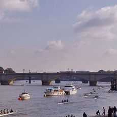
The University Boat Race Stones are two granite blocks positioned along the southern banks of the Thames that mark the precise start and finish lines for competitive rowing events. One sits near Putney Bridge while the other stands at Mortlake, establishing the exact route that rowers have followed for generations.
These stones were first established in 1829 to mark the boundaries of the University Boat Race between Oxford and Cambridge. Since then they have served as fixed reference points for one of Britain's oldest and most famous sporting competitions.
The annual University Boat Race course, spanning 6,779 meters from Putney to Mortlake, remains defined by these enduring stone markers.
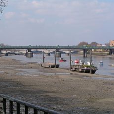
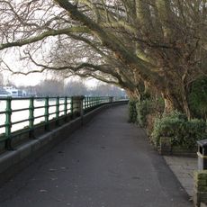
Both stones can be easily spotted from the Thames embankment promenade, particularly during a walk along the riverbanks between the two bridges. Early in the day is best for visiting and observing them in a quieter setting before river traffic becomes heavy.
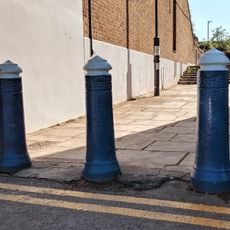
A pyramid-topped post painted in Oxford and Cambridge blue colors stands opposite the finish stone and provides a visual marker that reinforces the race boundary. This colorful reference point helps both spectators and rowers clearly identify the exact finishing line of the competition.
Location: London
GPS coordinates: 51.46670,-0.21520
Latest update: December 12, 2025 07:56
Putney Bridge
126 m
The Half Moon
357 m
All Saints' Church, Fulham
322 m
Fulham Railway Bridge
392 m
Bishops Park
376 m
St. Mary's Church, Putney
151 m
White Lion
114 m
Putney Wharf Tower
200 m
Duke's Head
150 m
Fulham War Memorial
368 m
Winchester House
171 m
Sir William Powell's Almshouses
374 m
37, 39 And 41, Lower Richmond Road Sw15
150 m
Tomb Of Thomas Sherlock Close To East Wall To North Of Tomb Of Henry Compton (In All Saints Churchyard, Fulham)
335 m
Tomb Of Bishop Robert Lowth, Due East Of Vestry (In All Saints Churchyard, Fulham)
342 m
All Saints Fulham war memorial
288 m
Tomb Of Granville Sharp, All Saints Churchyard
354 m
Motherfigure
300 m
The Turning Point
206 m
Tomb Of Francis Child Close To South Wall Of South Chapel And Churchyard Of All Saints Church
315 m
Tomb Of Burchell Family Including William Burchell, Located Approximately 2M From The South Elevation Of All Saints Church
304 m
Putney War Memorial
153 m
Walls Of Old Garden
365 m
Punch & Judy
207 m
3 Bollards At Junction With Putney Embankment
354 m
Load
13 m
Horizontal Ambiguity
124 m
Bollard At Junction With Lower Richmond Road
345 mVisited this place? Tap the stars to rate it and share your experience / photos with the community! Try now! You can cancel it anytime.
Discover hidden gems everywhere you go!
From secret cafés to breathtaking viewpoints, skip the crowded tourist spots and find places that match your style. Our app makes it easy with voice search, smart filtering, route optimization, and insider tips from travelers worldwide. Download now for the complete mobile experience.
A unique approach to discovering new places❞
— Le Figaro
All the places worth exploring❞
— France Info
A tailor-made excursion in just a few clicks❞
— 20 Minutes