Wincobank

Log in to your account

AroundUs is a community-driven map of interesting places, built by curious explorers like you. It grows with every review, story, and photo you share.
Connect to save your favorite spots, contribute locations, and create personalized routes.
By continuing, you accept our Terms and Conditions and our Privacy Policy
Add to collection
Map
Suggest a change
Share

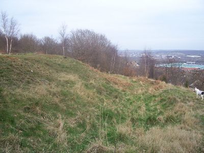
Wincobank, Iron Age contour fort in Sheffield, England.

Wincobank is an oval-shaped hillfork perched on a sandstone hill near Sheffield with visible earthwork defenses that look out over the River Don valley. The fortification features surviving banks and ditches that mark its ancient boundaries and protective system.

This fortification was built around 500 BC by the Celtic Brigantes tribe, overturning earlier theories about its origins. Radiocarbon dating has confirmed this early timeline for the settlement.

The site reveals ancient construction techniques visible in its earthwork structures that archaeologists continue to study. These physical remains help visitors understand how people engineered their defenses thousands of years ago.

The main entrance sits on the south-east side and is accessible from the surrounding area. The surviving earthworks remain well-defined, making it possible to walk around and examine the fort's layout and defenses.

The rampart materials show signs of vitrification from exposure to extreme heat that fused the rocks together. This unusual feature suggests the fort experienced intense fire at some point in its past.

Location: South Yorkshire

Location: Sheffield

Part of: Wincobank slight univallate hillfort and World War II anti-aircraft gun and searchlight emplacement

GPS coordinates: 53.41437,-1.43305

Latest update: December 10, 2025 20:08

Photos
Around this place
Meadowhall Centre
United Kingdom

Meadowhall Centre

1.5 km
Tinsley Viaduct
United Kingdom

Tinsley Viaduct

1.8 km
Valley Centertainment
United Kingdom

Valley Centertainment

1.9 km
Man of Steel
United Kingdom

Man of Steel

2.1 km
Blackburn Meadows
United Kingdom

Blackburn Meadows

2.2 km
Carbrook Hall
United Kingdom

Carbrook Hall

1.5 km
Attercliffe Chapel
United Kingdom

Attercliffe Chapel

1.7 km
Firth Park
United Kingdom

Firth Park

906 m
St Thomas, Brightside
United Kingdom

St Thomas, Brightside

859 m
Church of St James and St Christopher
United Kingdom

Church of St James and St Christopher

1.7 km
Church of St Thomas
United Kingdom

Church of St Thomas

1.2 km
Church of St Cuthbert
United Kingdom

Church of St Cuthbert

1.4 km
Trinity Fir Vale Methodist Church
United Kingdom

Trinity Fir Vale Methodist Church

1.3 km
War Memorial 400 Metres North East of Chapel at Burngreave Cemetery
United Kingdom

War Memorial 400 Metres North East of Chapel at Burngreave Cemetery

2.2 km
Adelphi Picture Theatre
United Kingdom

Adelphi Picture Theatre

2 km
Grimesthorpe Pump
United Kingdom

Grimesthorpe Pump

903 m
Sheffield City Council Sport And Development Section District Office
United Kingdom

Sheffield City Council Sport And Development Section District Office

770 m
Firth Park Methodist Church, Adjoining Meeting Room And Boundary Wall
United Kingdom

Firth Park Methodist Church, Adjoining Meeting Room And Boundary Wall

1.1 km
18, 20 And 22, Page Hall Road
United Kingdom

18, 20 And 22, Page Hall Road

1.2 km
Sewer Gas Lamp at Junction with Tipton Lane
United Kingdom

Sewer Gas Lamp at Junction with Tipton Lane

593 m
Workshop At Darnall Works Approximately 40 Metres To South East Of Number 20 (Number 20 Not Included)
United Kingdom

Workshop At Darnall Works Approximately 40 Metres To South East Of Number 20 (Number 20 Not Included)

2.5 km
Royal Bank of Scotland
United Kingdom

Royal Bank of Scotland

2.1 km
1-7, Hatfield House Croft
United Kingdom

1-7, Hatfield House Croft

1.6 km
Boundary Walls And Gate Piers To Church Of St Thomas
United Kingdom

Boundary Walls And Gate Piers To Church Of St Thomas

1.2 km
Workshop At Darnall Works Approximately 30 Metres South West Of Number 20 (Number 20 Not Included)
United Kingdom

Workshop At Darnall Works Approximately 30 Metres South West Of Number 20 (Number 20 Not Included)

2.5 km
Sewer Gas Lamp at Junction with Monckton Road
United Kingdom

Sewer Gas Lamp at Junction with Monckton Road

462 m
Enchanted Chairs
United Kingdom

Enchanted Chairs

386 m
Spider's Web Sculpture
United Kingdom

Spider's Web Sculpture

2.3 km
Show the full map
Reviews

Visited this place? Tap the stars to rate it and share your experience / photos with the community! Try now! You can cancel it anytime.

« Wincobank - Iron Age contour fort in Sheffield, England » is provided by Around Us (aroundus.com). Images and texts are derived from Wikimedia project under a Creative Commons license. You are allowed to copy, distribute, and modify copies of this page, under the conditions set by the license, as long as this note is clearly visible.

Discover hidden gems everywhere you go!

From secret cafés to breathtaking viewpoints, skip the crowded tourist spots and find places that match your style. Our app makes it easy with voice search, smart filtering, route optimization, and insider tips from travelers worldwide. Download now for the complete mobile experience.

Around Us App Screenshot

A unique approach to discovering new places

Le Figaro

All the places worth exploring

France Info

A tailor-made excursion in just a few clicks

20 Minutes