Tinsley Viaduct

Log in to your account

AroundUs is a community-driven map of interesting places, built by curious explorers like you. It grows with every review, story, and photo you share.
Connect to save your favorite spots, contribute locations, and create personalized routes.
Continue with Google
Continue with Apple
Continue with X
Continue with Facebook
Continue with email
By continuing, you accept our Terms and Conditions and our Privacy Policy
Create an account

Tinsley Viaduct

Add to collection
Map
Suggest a change
Share

Tinsley Viaduct, Road bridge in Sheffield, England

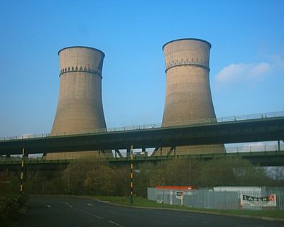
Tinsley Viaduct is a two-level road bridge in Sheffield that extends roughly 1036 meters (3400 feet) across the Don Valley. The M1 motorway runs on the upper level while the four-lane A631 uses the lower deck.

Work on the viaduct started in 1965 under the direction of Freeman Fox & Partners. The lower level opened on March 25, 1968, and the upper level followed on October 19 that year.

The structure takes its name from the nearby Tinsley district and has become part of Sheffield's industrial landscape. Commuters and travelers cross the two-tier construction daily as it blends into the busy Don Valley scene.

Drivers crossing over or under the viaduct will notice the profile of the double roadway and steel supports. The lower level carries essential service lines for gas, electricity, and water alongside traffic.

The bridge rests on 17 pairs of box-shaped columns made from high tensile steel. These columns contain special jacking facilities that allow adjustments for temperature changes and ground subsidence.

Official opening: March 25, 1968

GPS coordinates: 53.41750,-1.40583

Latest update: December 5, 2025 22:31

Photos
Around this place
Meadowhall Centre
United Kingdom

Meadowhall Centre

482 m
Magna Science Adventure Centre
United Kingdom

Magna Science Adventure Centre

1.2 km
Man of Steel
United Kingdom

Man of Steel

827 m
Wincobank
United Kingdom

Wincobank

1.8 km
Blackburn Meadows
United Kingdom

Blackburn Meadows

517 m
Carbrook Hall
United Kingdom

Carbrook Hall

1.5 km
Attercliffe Chapel
United Kingdom

Attercliffe Chapel

2.5 km
United Kingdom

Firth Park

2.7 km
St Bede's Church, Rotherham
United Kingdom

St Bede's Church, Rotherham

2.9 km
St Thomas, Brightside
United Kingdom

St Thomas, Brightside

2.1 km
Church of St James and St Christopher
United Kingdom

Church of St James and St Christopher

2.7 km
Church of St Thomas
United Kingdom

Church of St Thomas

950 m
Church of St Lawrence
United Kingdom

Church of St Lawrence

1.1 km
Church of St Thomas
United Kingdom

Church of St Thomas

2 km
Tinsley Park Cemetery War Memorial, Sheffield
United Kingdom

Tinsley Park Cemetery War Memorial, Sheffield

2.7 km
Milestone, Templeborough, at jct of Deadmans Hole Lane, W of Magna
United Kingdom

Milestone, Templeborough, at jct of Deadmans Hole Lane, W of Magna

868 m
Adelphi Picture Theatre
United Kingdom

Adelphi Picture Theatre

2.9 km
Firth Park Methodist Church, Adjoining Meeting Room And Boundary Wall
United Kingdom

Firth Park Methodist Church, Adjoining Meeting Room And Boundary Wall

2.8 km
Sheffield City Council Sport And Development Section District Office
United Kingdom

Sheffield City Council Sport And Development Section District Office

2.6 km
18, 20 And 22, Page Hall Road
United Kingdom

18, 20 And 22, Page Hall Road

3 km
Grimesthorpe Pump
United Kingdom

Grimesthorpe Pump

2.5 km
Royal Bank of Scotland
United Kingdom

Royal Bank of Scotland

2.9 km
Milepost Opposite Junction With Old Wortley Road
United Kingdom

Milepost Opposite Junction With Old Wortley Road

2.5 km
Milepost Opposite Junction With Bonet Lane
United Kingdom

Milepost Opposite Junction With Bonet Lane

2 km
Sewer Gas Lamp at Junction with Tipton Lane
United Kingdom

Sewer Gas Lamp at Junction with Tipton Lane

1.3 km
Boundary Walls And Gate Piers To Church Of St Thomas
United Kingdom

Boundary Walls And Gate Piers To Church Of St Thomas

938 m
Sewer Gas Lamp at Junction with Monckton Road
United Kingdom

Sewer Gas Lamp at Junction with Monckton Road

1.9 km
Milestone, Bawtry Road, Brinsworth, 150m W of Bonet Lane opp pedestrian refuge in road
United Kingdom

Milestone, Bawtry Road, Brinsworth, 150m W of Bonet Lane opp pedestrian refuge in road

2 km
Show the full map
Reviews

Visited this place? Tap the stars to rate it and share your experience / photos with the community! Try now! You can cancel it anytime.

« Tinsley Viaduct - Road bridge in Sheffield, England » is provided by Around Us (aroundus.com). Images and texts are derived from Wikimedia project under a Creative Commons license. You are allowed to copy, distribute, and modify copies of this page, under the conditions set by the license, as long as this note is clearly visible.

Discover hidden gems everywhere you go!

From secret cafés to breathtaking viewpoints, skip the crowded tourist spots and find places that match your style. Our app makes it easy with voice search, smart filtering, route optimization, and insider tips from travelers worldwide. Download now for the complete mobile experience.

Around Us App Screenshot

A unique approach to discovering new places

Le Figaro

All the places worth exploring

France Info

A tailor-made excursion in just a few clicks

20 Minutes