Enable Location

We need your location to show you interesting places around you

Discover nearby places

Find interesting locations and hidden gems around you

Precise directions

Get accurate directions and distances to places

Your location is never shared with other users. It's only used when you tap the location button.

Blackburn Meadows

Log in to your account

Start exploring — it's free

Trusted by 62,900 travelers worldwide

Continue with Google
Continue with Apple
or

We will send you a code to connect

By continuing, you accept our Terms and Conditions and our Privacy Policy

Check your inbox

We've sent a pincode in your inbox. Please enter the code below.

Blackburn Meadows
Discussion Reviews 1 Photos
4k Popularity

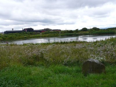
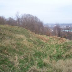
Blackburn Meadows, Nature reserve in Sheffield, United Kingdom

Blackburn Meadows is a nature reserve in Sheffield featuring expansive wetlands, walking trails, and observation areas positioned throughout the site. The landscape combines shallow water bodies with grassland, creating multiple viewpoints for watching wildlife in different seasons.

The site was once industrial land that transformed into a nature reserve in 1993 following negotiations between Sheffield City Council and Yorkshire Water. This conversion from abandoned industrial ground into a natural space became significant for the city's environmental recovery.

The place serves as a space where visitors can observe bird life and learn about wetland ecosystems firsthand. People come to watch how nature thrives within an urban setting and understand the value of preserving such habitats.

The reserve can be accessed from several entry points and has parking areas nearby, with paths designed for casual walking. Sturdy shoes and waterproof clothing are recommended, as trails can become muddy, especially after rain.

The reserve plays a hidden role in managing water flow for the surrounding city and helps prevent flooding in nearby neighborhoods. Most visitors do not realize that these quiet water bodies actively work to protect Sheffield from overflow during heavy rainfall.

The community of curious travelers

AroundUs brings together thousands of curated places, local tips, and hidden gems, enriched daily by 60,000 contributors worldwide.

Start exploring
Location
GPS coordinates
53.42170,-1.40250
Latest update
December 11, 2025 18:01
Around this place
Meadowhall Centre
United Kingdom

Meadowhall Centre

984 m
Tinsley Viaduct
United Kingdom

Tinsley Viaduct

517 m
Valley Centertainment
United Kingdom

Valley Centertainment

2.3 km
Magna Science Adventure Centre
United Kingdom

Magna Science Adventure Centre

970 m
Man of Steel
United Kingdom

Man of Steel

465 m
Keppel's Column
United Kingdom

Keppel's Column

3 km
Wincobank
United Kingdom

Wincobank

2.2 km
Carbrook Hall
United Kingdom

Carbrook Hall

2 km
Attercliffe Chapel
United Kingdom

Attercliffe Chapel

3 km
United Kingdom

Firth Park

3 km
St Bede's Church, Rotherham
United Kingdom

St Bede's Church, Rotherham

2.5 km
St Thomas, Brightside
United Kingdom

St Thomas, Brightside

2.6 km
Church of St James and St Christopher
United Kingdom

Church of St James and St Christopher

2.8 km
Church of St Thomas
United Kingdom

Church of St Thomas

1.1 km
Church of St Lawrence
United Kingdom

Church of St Lawrence

1.3 km
Church of St Thomas
United Kingdom

Church of St Thomas

1.5 km
Tinsley Park Cemetery War Memorial, Sheffield
United Kingdom

Tinsley Park Cemetery War Memorial, Sheffield

3.1 km
Milestone, Templeborough, at jct of Deadmans Hole Lane, W of Magna
United Kingdom

Milestone, Templeborough, at jct of Deadmans Hole Lane, W of Magna

739 m
Firth Park Methodist Church, Adjoining Meeting Room And Boundary Wall
United Kingdom

Firth Park Methodist Church, Adjoining Meeting Room And Boundary Wall

3.1 km
Sheffield City Council Sport And Development Section District Office
United Kingdom

Sheffield City Council Sport And Development Section District Office

2.9 km
Grimesthorpe Pump
United Kingdom

Grimesthorpe Pump

2.9 km
Boundary Walls And Gate Piers To Church Of St Thomas
United Kingdom

Boundary Walls And Gate Piers To Church Of St Thomas

1.1 km
Milepost Opposite Junction With Bonet Lane
United Kingdom

Milepost Opposite Junction With Bonet Lane

2.1 km
Milepost Opposite Junction With Old Wortley Road
United Kingdom

Milepost Opposite Junction With Old Wortley Road

2 km
Sewer Gas Lamp at Junction with Tipton Lane
United Kingdom

Sewer Gas Lamp at Junction with Tipton Lane

1.6 km
Sewer Gas Lamp at Junction with Monckton Road
United Kingdom

Sewer Gas Lamp at Junction with Monckton Road

2.2 km
Milestone, Bawtry Road, Brinsworth, 150m W of Bonet Lane opp pedestrian refuge in road
United Kingdom

Milestone, Bawtry Road, Brinsworth, 150m W of Bonet Lane opp pedestrian refuge in road

2.2 km
Enchanted Chairs
United Kingdom

Enchanted Chairs

2.2 km
Show the full map
« Blackburn Meadows - Nature reserve in Sheffield, United Kingdom » is provided by Around Us (aroundus.com). Images and texts are derived from Wikimedia project under a Creative Commons license. You are allowed to copy, distribute, and modify copies of this page, under the conditions set by the license, as long as this note is clearly visible.

Discover hidden gems everywhere you go!

From secret cafés to breathtaking viewpoints, skip the crowded tourist spots and find places that match your style. Our app makes it easy with voice search, smart filtering, route optimization, and insider tips from travelers worldwide. Download now for the complete mobile experience.

Around Us App Screenshot

A unique approach to discovering new places

Le Figaro

All the places worth exploring

France Info

A tailor-made excursion in just a few clicks

20 Minutes

Around Us
Travel Guide & Maps
Download

Send to your phone

QR Code
1

Open the camera app on your mobile.

2

Point at the QR code with your camera. A notification will appear.

3

Tap the notification to open the link.