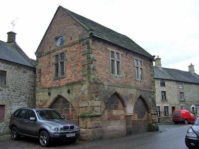
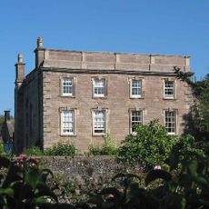
Winster Market House, Market hall in Winster, England.
Winster Market House is a stone market building with a gabled roof and large open space beneath it, standing prominently on Main Street. The interior is divided into two levels, with the lower level displaying exhibitions and the upper level housing a scale model of the town.
The building was commissioned in the late 1500s by Gervase and Anthony Eyre, shaping the structure of the town at that time. In 1906 it became the National Trust's first acquisition in Derbyshire, and has preserved the character of that era ever since.
The name derives from the Eyre family who commissioned the building and held influence in the area for generations. Today the exhibition spaces show how closely residents were connected to mining, which shaped life throughout Derbyshire.
The building is easily accessible from Main Street and allows visitors to explore both levels independently. It is worth allowing enough time to view the exhibitions at leisure and appreciate the details of the architecture.
The building shows an interesting development: originally it was an open market space, but was later enclosed with a roof and walls. This change reflects how British trading and living habits evolved over the centuries.
Location: Winster
Website: https://nationaltrust.org.uk/winster-market-house
GPS coordinates: 53.14160,-1.64046
Latest update: December 14, 2025 17:43
Robin Hood's Stride
2.4 km
Doll Tor
2.3 km
Nine Stones Close
2.6 km
Andle Stone
2.4 km
St Michael's Church, Birchover
1.7 km
Duke of York Inn
2 km
Winster Hall
43 m
Old Millclose engine house and associated features, 570m south west of Cowley Hall
2.1 km
St John the Baptist's Church, Winster
227 m
All Saints' Church, Elton
2 km
Rowtor Rocks
2.2 km
Green Low chambered tomb
2.7 km
Druid Inn
1.7 km
Village Well
1.6 km
The Youth Hostel
1.8 km
Holmelea
139 m
Bank Top Farmhouse
439 m
The Old Shoulder Of Mutton Inn
161 m
Cratcliff Rocks hermitage
2.3 km
Milestone 150 Metres South West Of Brimsbury Well
1.9 km
Barker Barn
2.2 km
Bronze Age burial, ceremonial and settlement remains on Stanton Moor, and evidence for medieval, post-medieval and 19th to early
2.7 km
Milepost 300 Yards South Of The Junction Of New Road And Chadwick Hill
749 m
Milepost 400 Yards South West Of Winstermoor Farm
1.3 km
Meadowside
1.6 km
Homestead Farmhouse And Homestead Cottage
1.9 km
Stables To The West Of The Duke Of York Inn
2 km
Holmedene Farmhouse
2 kmVisited this place? Tap the stars to rate it and share your experience / photos with the community! Try now! You can cancel it anytime.
Discover hidden gems everywhere you go!
From secret cafés to breathtaking viewpoints, skip the crowded tourist spots and find places that match your style. Our app makes it easy with voice search, smart filtering, route optimization, and insider tips from travelers worldwide. Download now for the complete mobile experience.
A unique approach to discovering new places❞
— Le Figaro
All the places worth exploring❞
— France Info
A tailor-made excursion in just a few clicks❞
— 20 Minutes