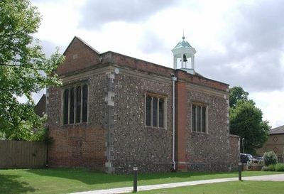
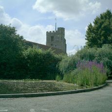
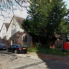
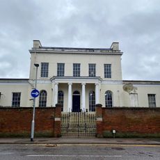
Oxhey Chapel, Gothic church building in Watford Rural, England.
Oxhey Chapel is a Gothic church building in Watford Rural with rectangular form and walls built from knapped flint and red brick with stone trim and a tiled roof. The building sits between the newer parish church and vicarage, representing an example of private worship structures from earlier centuries.
The chapel was built in 1612 by Sir James Altham as a private place of worship for his family and staff at nearby Oxhey Place. The structure reflects the tradition of family chapels that wealthy households constructed during this period.
The interior features wooden benches arranged to face each other in a collegiate style, with an ornate reredos displaying twisted columns and religious inscriptions.
The building sits in a quiet location between the newer parish facilities and is straightforward to reach on foot. Carpenders Park Overground station lies roughly 800 meters away and provides convenient access by public transport.
During the English Civil War in 1649, parliamentary forces used the chapel as a storage space and melted down portions of its lead roof to make musket balls. This episode reveals how the building became caught up in the conflicts of the time.
Location: Watford Rural
Inception: 1612
Architectural style: English Gothic architecture
Website: http://visitchurches.org.uk/Ourchurches/Completelistofchurches/Oxhey-Chapel-Oxhey-Hertfordshire
GPS coordinates: 51.62793,-0.39255
Latest update: December 14, 2025 09:40
Vicarage Road
2.5 km
Watford Museum
2.7 km
Eastbury Park
1.6 km
Oxhey Woods
1.5 kmThe Lairage Land
2.1 km
Prestwick Road Meadows
1.2 km
Bushey Museum
2.7 km
Church of St James
2.5 km
St Anselm's Church
2.5 km
Bushey War Memorial
2.8 km
Bushey Arches Railway Viaduct
2.2 km
London Coal Duty Marker On County Boundary Where Road Meets Potter Street Hill
1.8 km
172, High Street
2.8 km
174, High Street
2.8 km
Pinner Hill Golf Club House, And Boundary Wall Extending Northwards From Club House
1.9 km
196 High Street
2.7 km
Tooke's Folly At Pinner Hill Farm
2.6 km
Watford Fields War Memorial
2.3 km
158, High Street
2.8 km
London Coal Duty Marker On County Boundary About 140 Metres South Of Road
2.8 km
Sparrows Herne Trust Turnpike Marker At Tq 1185 9553
2.2 km
62-68, High Street
2.6 km
Church View
2.6 km
160, High Street
2.8 km
London Coal Duty Marker On County Boundary On East Railway Embankment About 350 Metres South Of Road
2.5 km
Coal Duty Boundary Post Outside Number 1 (The Hollies)
1.9 km
Watford Place
2.8 km
166 And 168, High Street
2.8 kmVisited this place? Tap the stars to rate it and share your experience / photos with the community! Try now! You can cancel it anytime.
Discover hidden gems everywhere you go!
From secret cafés to breathtaking viewpoints, skip the crowded tourist spots and find places that match your style. Our app makes it easy with voice search, smart filtering, route optimization, and insider tips from travelers worldwide. Download now for the complete mobile experience.
A unique approach to discovering new places❞
— Le Figaro
All the places worth exploring❞
— France Info
A tailor-made excursion in just a few clicks❞
— 20 Minutes