Enable Location

We need your location to show you interesting places around you

Discover nearby places

Find interesting locations and hidden gems around you

Precise directions

Get accurate directions and distances to places

Your location is never shared with other users. It's only used when you tap the location button.

Log in to your account

Start exploring — it's free

Trusted by 68,136 travelers worldwide

Continue with Google
Continue with Apple
or

We will send you a code to connect

By continuing, you accept our Terms and Conditions and our Privacy Policy

Check your inbox

We've sent a pincode in your inbox. Please enter the code below.

Cranebank
Discussion Reviews Photo
1.5k Popularity

Cranebank, Local nature reserve in Hatton, London Borough of Hounslow, United Kingdom.

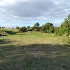
Cranebank is a local nature reserve in Hatton featuring water meadows along the River Crane, including ox-bow lakes and various plant species such as cuckoo flower and ragged robin. The land is managed through natural grazing by cattle.

The area developed from farmland called Dudset Farm Pastures into a protected nature reserve, established to protect local ecosystems from urban development. This transformation preserved these valuable wetlands for future generations.

The reserve is part of the London Loop walking route, linking residents to natural spaces in the city. People use the paths here for peaceful walks and birdwatching.

The reserve is accessible year-round through entry points at Earhart Way and Waye Avenue Open Space. Wear sturdy footwear as the wetland areas can become muddy, especially after rain.

The grasslands support more than 26 butterfly species and 12 types of damselflies and dragonflies, maintained through natural grazing. This abundance makes the reserve a rare refuge for insects in the middle of the city.

The community of curious travelers

AroundUs brings together thousands of curated places, local tips, and hidden gems, enriched daily by 60,000 contributors worldwide.

Start exploring
GPS coordinates
51.47302,-0.41410
Latest update
December 14, 2025 14:45
Around this place
Queens Building, Heathrow
United Kingdom

Queens Building, Heathrow

2.5 km
Duke of Northumberland's River
United Kingdom

Duke of Northumberland's River

1.7 km
St George’s Interdenominational Chapel, Heathrow Airport
United Kingdom

St George’s Interdenominational Chapel, Heathrow Airport

2.8 km
Slipstream
United Kingdom

Slipstream

2.5 km
Western International Market
United Kingdom

Western International Market

2.7 km
Hounslow Heath Golf Centre
United Kingdom

Hounslow Heath Golf Centre

1.9 km
Harlington Locomotive Society
United Kingdom

Harlington Locomotive Society

2.2 km
Skyteam Lounge Terminal 4
United Kingdom

Skyteam Lounge Terminal 4

2.6 km
Church of St Mary
United Kingdom

Church of St Mary

3 km
Church of St Peter and St Paul, Harlington
United Kingdom

Church of St Peter and St Paul, Harlington

2.6 km
Church of St Dunstan
United Kingdom

Church of St Dunstan

2.1 km
The White Hart Public House
United Kingdom

The White Hart Public House

2.4 km
Church of St Paul
United Kingdom

Church of St Paul

2.3 km
Monument at north-western end of General Roy's survey base
United Kingdom

Monument at north-western end of General Roy's survey base

2.6 km
Heston War Memorial
United Kingdom

Heston War Memorial

3.1 km
Tesco
United Kingdom

Tesco

1.5 km
Green Man Public House
United Kingdom

Green Man Public House

856 m
Tower And Spire Of Former Church Of St Catherine
United Kingdom

Tower And Spire Of Former Church Of St Catherine

2.9 km
Bull's Bridge Number 21 Over Grand Union Canal And Grand Union Canal (Paddington Branch) Junction
United Kingdom

Bull's Bridge Number 21 Over Grand Union Canal And Grand Union Canal (Paddington Branch) Junction

3 km
Brentford Fountain Western International Market
United Kingdom

Brentford Fountain Western International Market

2.6 km
Harlington War Memorial
United Kingdom

Harlington War Memorial

2.5 km
Bedfont war memorial
United Kingdom

Bedfont war memorial

2.8 km
Burlington House  and Flanking Walls Of Burlington House
United Kingdom

Burlington House and Flanking Walls Of Burlington House

3 km
Milestone Opposite Islay Gardens
United Kingdom

Milestone Opposite Islay Gardens

2 km
Milestone 12 Miles From London
United Kingdom

Milestone 12 Miles From London

1.8 km
Milestone 13 Miles From London
United Kingdom

Milestone 13 Miles From London

2.7 km
New Brentford Cemetery Cross of Sacrifice, Hounslow
United Kingdom

New Brentford Cemetery Cross of Sacrifice, Hounslow

2.6 km
Milestone, Bath Road; Harlington Corner (was Coach & Horses corner, later Arial Hotel)
United Kingdom

Milestone, Bath Road; Harlington Corner (was Coach & Horses corner, later Arial Hotel)

1.7 km
Show the full map
Reviews
Share your experience

No review yet

Discussions
Start a discussion...

No discussion yet

« Cranebank - Local nature reserve in Hatton, London Borough of Hounslow, United Kingdom » is provided by Around Us (aroundus.com). Images and texts are derived from Wikimedia project under a Creative Commons license. You are allowed to copy, distribute, and modify copies of this page, under the conditions set by the license, as long as this note is clearly visible.

Discover hidden gems everywhere you go!

From secret cafés to breathtaking viewpoints, skip the crowded tourist spots and find places that match your style. Our app makes it easy with voice search, smart filtering, route optimization, and insider tips from travelers worldwide. Download now for the complete mobile experience.

Around Us App Screenshot

A unique approach to discovering new places

Le Figaro

All the places worth exploring

France Info

A tailor-made excursion in just a few clicks

20 Minutes

Around Us
Travel Guide & Maps
Download

Send to your phone

QR Code
1

Open the camera app on your mobile.

2

Point at the QR code with your camera. A notification will appear.

3

Tap the notification to open the link.