Enable Location

We need your location to show you interesting places around you

Discover nearby places

Find interesting locations and hidden gems around you

Precise directions

Get accurate directions and distances to places

Your location is never shared with other users. It's only used when you tap the location button.

Christ Church, Adlington

Log in to your account

Start exploring — it's free

Trusted by 62,440 travelers worldwide

Continue with Google
Continue with Apple
or

We will send you a code to connect

By continuing, you accept our Terms and Conditions and our Privacy Policy

Check your inbox

We've sent a pincode in your inbox. Please enter the code below.

Christ Church, Adlington

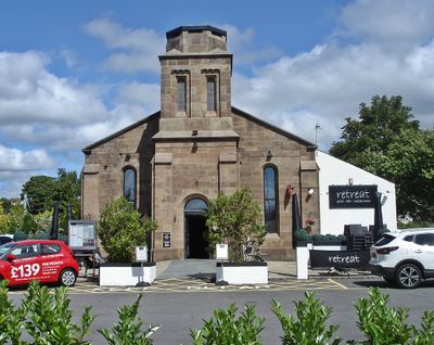
Christ Church, Adlington, Grade II listed church in Adlington, England

Christ Church is a Grade II listed building on Church Street in Adlington with walls of ashlar stone and a two-stage tower featuring angle buttresses and round-headed windows. An octagonal drum crowns the tower, where a spire once stood before its removal.

The building was designed in 1839 by architect Edward Welch and constructed with support from the Church Building Commission. After its closure as a church in 1980, it was later transformed into a restaurant space.

The building displays Norman-influenced features such as rounded arches and proportions common in 19th-century English churches. Visitors can observe these architectural details directly when entering the space.

The building now functions as a restaurant space and is easily located on Church Street in Adlington. Visitors should know that it is a private venue and viewing depends on the current opening hours.

Inside are three preserved paneled galleries, offering a rare glimpse into the furnishings of Victorian churches. These structures date from the original construction period and show how the space was once used.

The community of curious travelers

AroundUs brings together thousands of curated places, local tips, and hidden gems, enriched daily by 60,000 contributors worldwide.

Start exploring
Location
Inception
1839
Architects
Edward Welch
Architectural style
Norman architecture
GPS coordinates
53.61370,-2.60430
Latest update
December 14, 2025 17:40
Around this place
Duxbury Hall
United Kingdom

Duxbury Hall

2.3 km
Lower Rivington Reservoir
United Kingdom

Lower Rivington Reservoir

2.5 km
St Paul's Church, Adlington
United Kingdom

St Paul's Church, Adlington

386 m
Upper Rivington Reservoir
United Kingdom

Upper Rivington Reservoir

2.7 km
Church of St Katherine
United Kingdom

Church of St Katherine

2.4 km
Canal Bridge Number 74 At Sd 595 156  Winstanley Bridge
United Kingdom

Canal Bridge Number 74 At Sd 595 156 Winstanley Bridge

2.5 km
Rigshaw Bridge Number 70
United Kingdom

Rigshaw Bridge Number 70

390 m
Leeds And Liverpool Canal Waterhouse Bridge
United Kingdom

Leeds And Liverpool Canal Waterhouse Bridge

1 km
Canal Bridge Number 71
United Kingdom

Canal Bridge Number 71

1.1 km
Canal Bridge Number 72 At Sd 596 146  Idle Bridge
United Kingdom

Canal Bridge Number 72 At Sd 596 146 Idle Bridge

1.5 km
Red House Bridge Number 68
United Kingdom

Red House Bridge Number 68

668 m
Canal Bridge Number 73
United Kingdom

Canal Bridge Number 73

2.2 km
Adlington And District War Memorial
United Kingdom

Adlington And District War Memorial

292 m
Headless Cross
United Kingdom

Headless Cross

1.8 km
Leeds Liverpool Canal, Canal Aqueduct Over River Douglas At Sd 599 124
United Kingdom

Leeds Liverpool Canal, Canal Aqueduct Over River Douglas At Sd 599 124

788 m
Leeds And Liverpool Canal Aberdeen Bridge (No.66)
United Kingdom

Leeds And Liverpool Canal Aberdeen Bridge (No.66)

1.5 km
Bellhouse Circa 10 Metres West Of Church Of Holy Trinity
United Kingdom

Bellhouse Circa 10 Metres West Of Church Of Holy Trinity

2.7 km
Barn Circa 50 Metres East Of Allanson Hall
United Kingdom

Barn Circa 50 Metres East Of Allanson Hall

417 m
Hall O' Th' Hill
United Kingdom

Hall O' Th' Hill

1.9 km
Leeds And Liverpool Canal Anderton Bridge (No.65)
United Kingdom

Leeds And Liverpool Canal Anderton Bridge (No.65)

1.9 km
Milepost 350 Metres South East Of Junction Of Wigan Lane And Rawlinson Lane
United Kingdom

Milepost 350 Metres South East Of Junction Of Wigan Lane And Rawlinson Lane

1.7 km
Allanson Hall
United Kingdom

Allanson Hall

450 m
Milestone, Grimeford
United Kingdom

Milestone, Grimeford

1.9 km
Milestone, Heath Charnock, nr Adlington
United Kingdom

Milestone, Heath Charnock, nr Adlington

1.7 km
Milepost, Coppull Brow Farm; by farm
United Kingdom

Milepost, Coppull Brow Farm; by farm

1.5 km
Milepost, Chorley Road; 60m S entrance Bore's Farm
United Kingdom

Milepost, Chorley Road; 60m S entrance Bore's Farm

2.4 km
Milestone, opp.  Supermarket, by No. 18
United Kingdom

Milestone, opp. Supermarket, by No. 18

636 m
Milestone, Blackrod
United Kingdom

Milestone, Blackrod

2.6 km
Show the full map
« Christ Church, Adlington - Grade II listed church in Adlington, England » is provided by Around Us (aroundus.com). Images and texts are derived from Wikimedia project under a Creative Commons license. You are allowed to copy, distribute, and modify copies of this page, under the conditions set by the license, as long as this note is clearly visible.

Discover hidden gems everywhere you go!

From secret cafés to breathtaking viewpoints, skip the crowded tourist spots and find places that match your style. Our app makes it easy with voice search, smart filtering, route optimization, and insider tips from travelers worldwide. Download now for the complete mobile experience.

Around Us App Screenshot

A unique approach to discovering new places

Le Figaro

All the places worth exploring

France Info

A tailor-made excursion in just a few clicks

20 Minutes

Around Us
Travel Guide & Maps
Download

Send to your phone

QR Code
1

Open the camera app on your mobile.

2

Point at the QR code with your camera. A notification will appear.

3

Tap the notification to open the link.