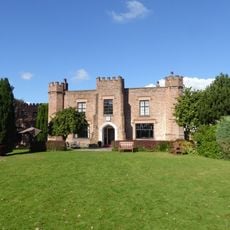
Dale Barracks, Military barracks in Chester, England
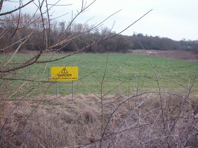
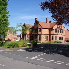
Dale Barracks is a military installation in Chester established in 1939 on land that was formerly occupied by Moston Hall. The compound contains multiple buildings, training facilities, and accommodation for hundreds of serving personnel across its grounds.
The barracks was built in 1939 on the former estate of Moston Hall and served as a Machine Gun Training Centre during World War II. After the war, it developed into a major garrison for various British regiments and military units.
The regimental museum displays uniforms and equipment from different eras, telling the story of units stationed here over time. Visitors can witness the connection between this facility and the local community through regular military ceremonies and public events.
Access to the barracks is restricted as it remains an active military facility, so visits require advance permission from the authorities. Contact ahead to confirm access conditions and inquire about any available guided tours or special visiting hours.
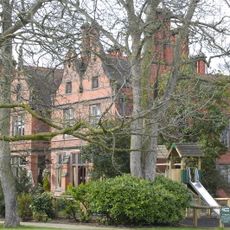
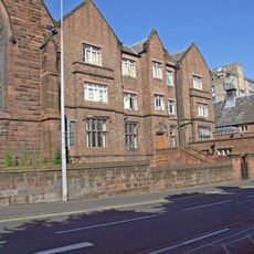
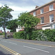
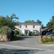
The site preserves Moston Hall, a Georgian country house from 1789 that was repurposed as a military hospital during World War I. This rare survival from before the barracks existed shows how the location transformed over time to serve different military purposes.
Location: Chester
Inception: 1939
GPS coordinates: 53.22528,-2.89500
Latest update: December 10, 2025 16:23
Chester Zoo
738 m
Oakfield Manor
1.1 km
St Thomas of Canterbury Church, Chester
3 km
Holy Ascension Church, Upton by Chester
1.2 km
St Oswald's Church, Backford
1.6 km
St Columba's Church, Chester
2.2 km
Chester College Chapel
2.9 km
Bache Hall
2.1 km
All Saints' Church, Hoole
3.1 km
Crabwall Manor
2.1 km
Countess of Chester Country Park
2 km
Knolls Bridge (Canal Bridge Number 131)
1.3 km
Milepost 80 Metres North Of Junction With Abbots Park
2.4 km
Hoole and Newton War Memorial
3.1 km
Chester College Old Building and wall, north east and south east
2.9 km
Mollington Viaduct
1 km
Lodge to Backford Hall
1.8 km
Sundial in churchyard of St Oswald's Church
1.6 km
Churchyard walls and gateway to church of St Oswald
1.6 km
Upton and District War Memorial Cross
1.3 km
Downswood
2.3 km
4 and 6, Abbots Grange
2.8 km
Blacon Cemetery Cross of Sacrifice
2.6 km
Milepost 30 Metres South Of Junction With Ormonde Road
2.3 km
Vicarage
1.8 km
Footpath Guidepost In North West Corner Of The Garden Of Longlands
173 m
Milepost, S of Backford Bridge
785 m
Milepost, E of Overwood Lane jcn
2.4 kmVisited this place? Tap the stars to rate it and share your experience / photos with the community! Try now! You can cancel it anytime.
Discover hidden gems everywhere you go!
From secret cafés to breathtaking viewpoints, skip the crowded tourist spots and find places that match your style. Our app makes it easy with voice search, smart filtering, route optimization, and insider tips from travelers worldwide. Download now for the complete mobile experience.
A unique approach to discovering new places❞
— Le Figaro
All the places worth exploring❞
— France Info
A tailor-made excursion in just a few clicks❞
— 20 Minutes