Enable Location

We need your location to show you interesting places around you

Discover nearby places

Find interesting locations and hidden gems around you

Precise directions

Get accurate directions and distances to places

Your location is never shared with other users. It's only used when you tap the location button.

Sutcliffe Park

Log in to your account

Start exploring — it's free

Trusted by 62,476 travelers worldwide

Continue with Google
Continue with Apple
or

We will send you a code to connect

By continuing, you accept our Terms and Conditions and our Privacy Policy

Check your inbox

We've sent a pincode in your inbox. Please enter the code below.

Sutcliffe Park

Sutcliffe Park, Urban park in Eltham, London, England

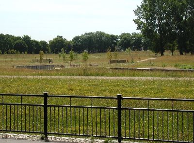
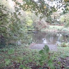
Sutcliffe Park is an urban park in Eltham with meadows, wetlands, and several lakes that the River Quaggy flows through. The site extends across about 17 hectares and includes an athletics track, outdoor exercise equipment, and children's play areas.

The land was formerly known as Harrow Meadow and was converted into playing fields by Woolwich Metropolitan Borough Council in 1937. Major renovations in the early 2000s modernized the park's facilities and improved its ecological value.

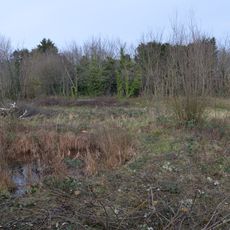
The central area holds designation as a Local Nature Reserve, which makes it a focus for environmental learning and community programs. Visitors can observe how wetlands and river corridors fit into the everyday life of the city.

The park is accessible through gates at Tudway Road and Eltham Road, with various facilities available throughout the grounds. Wear sturdy shoes when visiting, as paths can become muddy especially after rain.

The River Quaggy was released from its underground culvert and now flows openly through the park as part of a flood defense system. This return of the river to the surface created new habitats for kingfishers and reed warblers.

The community of curious travelers

AroundUs brings together thousands of curated places, local tips, and hidden gems, enriched daily by 60,000 contributors worldwide.

Start exploring
Location
GPS coordinates
51.45500,0.02900
Latest update
December 12, 2025 09:06
Around this place
Eltham Palace
United Kingdom

Eltham Palace

1.6 km
Ferrier Estate
United Kingdom

Ferrier Estate

574 m
Manor House Gardens
United Kingdom

Manor House Gardens

1.6 km
Bob Hope Theatre
United Kingdom

Bob Hope Theatre

1.6 km
Church of St Michael and All Angels
United Kingdom

Church of St Michael and All Angels

1.5 km
The Tudor Barn
United Kingdom

The Tudor Barn

1.4 km
Burnt Ash Pond
United Kingdom

Burnt Ash Pond

1.5 km
Birdbrook Road Nature Reserve
United Kingdom

Birdbrook Road Nature Reserve

762 m
Eltham Palace
United Kingdom

Eltham Palace

1.6 km
Church of St John the Baptist
United Kingdom

Church of St John the Baptist

1.6 km
Church of St Saviour
United Kingdom

Church of St Saviour

944 m
Church of St James
United Kingdom

Church of St James

1.7 km
Roman Catholic Church of St Mary
United Kingdom

Roman Catholic Church of St Mary

1.7 km
Museum of Neoliberalism
United Kingdom

Museum of Neoliberalism

1.2 km
Eltham War Memorial
United Kingdom

Eltham War Memorial

1.6 km
St Mildred's Church
United Kingdom

St Mildred's Church

1.6 km
Eltham Court (Eltham Palace)
United Kingdom

Eltham Court (Eltham Palace)

1.6 km
Remains Of South Bridge Across Eltham Palace Moat
United Kingdom

Remains Of South Bridge Across Eltham Palace Moat

1.6 km
Men of St Peter's War Memorial, Lee
United Kingdom

Men of St Peter's War Memorial, Lee

485 m
Old Wall Along South And East Sides Of Churchyard, Church Of St John The Baptist
United Kingdom

Old Wall Along South And East Sides Of Churchyard, Church Of St John The Baptist

1.6 km
Milestone Fixed To The Wall Of The Chequers Public House (Number 34)
United Kingdom

Milestone Fixed To The Wall Of The Chequers Public House (Number 34)

1.5 km
Hallgate
United Kingdom

Hallgate

1.4 km
Fairmount Ladies Rest Home
United Kingdom

Fairmount Ladies Rest Home

1.7 km
Milestone, Lee High Road, W of jct with Lenham Road
United Kingdom

Milestone, Lee High Road, W of jct with Lenham Road

1.6 km
North Bridge Across Eltham Palace Moat
United Kingdom

North Bridge Across Eltham Palace Moat

1.6 km
Walls Of Inner Courtyard To Eltham Palace, With Chambers Adjoining
United Kingdom

Walls Of Inner Courtyard To Eltham Palace, With Chambers Adjoining

1.6 km
Milestone, Mottingham Lane, E of jct with Winn Road
United Kingdom

Milestone, Mottingham Lane, E of jct with Winn Road

1.5 km
Milestone, Eltham Road, Eof Kidbrooke Park Road, S of Sutcliffe Park (stadium)
United Kingdom

Milestone, Eltham Road, Eof Kidbrooke Park Road, S of Sutcliffe Park (stadium)

222 m
Show the full map
« Sutcliffe Park - Urban park in Eltham, London, England » is provided by Around Us (aroundus.com). Images and texts are derived from Wikimedia project under a Creative Commons license. You are allowed to copy, distribute, and modify copies of this page, under the conditions set by the license, as long as this note is clearly visible.

Discover hidden gems everywhere you go!

From secret cafés to breathtaking viewpoints, skip the crowded tourist spots and find places that match your style. Our app makes it easy with voice search, smart filtering, route optimization, and insider tips from travelers worldwide. Download now for the complete mobile experience.

Around Us App Screenshot

A unique approach to discovering new places

Le Figaro

All the places worth exploring

France Info

A tailor-made excursion in just a few clicks

20 Minutes

Around Us
Travel Guide & Maps
Download

Send to your phone

QR Code
1

Open the camera app on your mobile.

2

Point at the QR code with your camera. A notification will appear.

3

Tap the notification to open the link.