Enable Location

We need your location to show you interesting places around you

Discover nearby places

Find interesting locations and hidden gems around you

Precise directions

Get accurate directions and distances to places

Your location is never shared with other users. It's only used when you tap the location button.

Needle's Eye

Log in to your account

Start exploring — it's free

Trusted by 61,907 travelers worldwide

Continue with Google
Continue with Apple
or

We will send you a code to connect

By continuing, you accept our Terms and Conditions and our Privacy Policy

Check your inbox

We've sent a pincode in your inbox. Please enter the code below.

Needle's Eye

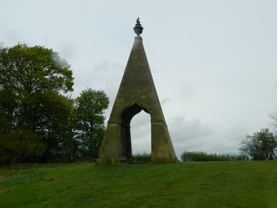
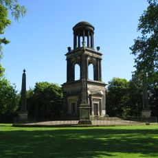
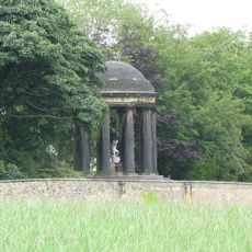
Needle's Eye, Grade II* listed folly in Wentworth, England.

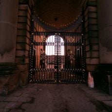
Needle's Eye is a 14 meter tall sandstone pyramid with a central archway and a funerary urn crowning its top. The monument stands between two former horse paths and features a distinctive architectural form that serves as a garden folly.

The monument was commissioned by the second Marquess of Rockingham in the mid-18th century and designed by architect John Carr. It was built as a garden folly during a period when such playful stone structures became fashionable on English estates.

The structure takes its name from a wager where the Marquess claimed he could drive a coach and horses through the eye of a needle. This peculiar tale remains connected to the place and makes it a talking point for visitors today.

The monument is accessible via footpaths that connect from Coaley Lane and pass between the two former horse paths. Visitors should expect the ground to become muddy depending on weather conditions, making sturdy footwear advisable.

One side of the structure displays numerous marks in the stone that some visitors interpret as possible musket ball impacts. These visible traces often leave observers intrigued and encourage speculation about the building's past.

The community of curious travelers

AroundUs brings together thousands of curated places, local tips, and hidden gems, enriched daily by 60,000 contributors worldwide.

Start exploring
Location
GPS coordinates
53.48460,-1.40437
Latest update
December 10, 2025 16:28
Around this place
Wentworth Woodhouse
United Kingdom

Wentworth Woodhouse

1.2 km
Hoober Stand
United Kingdom

Hoober Stand

1.2 km
Elsecar Heritage Railway
United Kingdom

Elsecar Heritage Railway

1.4 km
Elsecar Heritage Centre
United Kingdom

Elsecar Heritage Centre

1.5 km
The Rockingham Mausoleum
United Kingdom

The Rockingham Mausoleum

2.5 km
Hoober Observatory
United Kingdom

Hoober Observatory

1.5 km
Old Holy Trinity Church, Wentworth
United Kingdom

Old Holy Trinity Church, Wentworth

1.4 km
Holy Trinity Church, Wentworth
United Kingdom

Holy Trinity Church, Wentworth

1.4 km
Elsecar Ironworks
United Kingdom

Elsecar Ironworks

1.4 km
Wentworth Garden Centre
United Kingdom

Wentworth Garden Centre

1.1 km
Christ Church
United Kingdom

Christ Church

3.3 km
Church of the Holy Trinity
United Kingdom

Church of the Holy Trinity

1.7 km
Church of the Holy Trinity
United Kingdom

Church of the Holy Trinity

3.3 km
Wentworth Hospital With Attached Front Railings Comprising School House, School Room, Attached Almshouses To Rear, Railings To Roadside
United Kingdom

Wentworth Hospital With Attached Front Railings Comprising School House, School Room, Attached Almshouses To Rear, Railings To Roadside

1.6 km
Princess Theatre, Hoyland
United Kingdom

Princess Theatre, Hoyland

3.3 km
Wentworth War Memorial
United Kingdom

Wentworth War Memorial

1.1 km
The Round House
United Kingdom

The Round House

1.8 km
Hoober Hall
United Kingdom

Hoober Hall

2.1 km
Mausoleum Lodge
United Kingdom

Mausoleum Lodge

2.4 km
Stable Block And Riding School
United Kingdom

Stable Block And Riding School

996 m
47, Clayfield Road
United Kingdom

47, Clayfield Road

810 m
Milestone Approximately 30 Metres To North West Of Mausoleum Lodge
United Kingdom

Milestone Approximately 30 Metres To North West Of Mausoleum Lodge

2.4 km
Ionic Temple At West End Of South Terrace
United Kingdom

Ionic Temple At West End Of South Terrace

1.4 km
Gateway With Attached Plinth Wall And Ironwork Screen Forming South Side Of South Court At Wentworth Woodhouse
United Kingdom

Gateway With Attached Plinth Wall And Ironwork Screen Forming South Side Of South Court At Wentworth Woodhouse

1.2 km
Elsecar Mill
United Kingdom

Elsecar Mill

1.6 km
Milepost Approximately 45 Metres To South West Of Junction With Kirby Lane
United Kingdom

Milepost Approximately 45 Metres To South West Of Junction With Kirby Lane

3.3 km
Roman Ridge: section 400yds (370m) long S of Abdy Farm
United Kingdom

Roman Ridge: section 400yds (370m) long S of Abdy Farm

3.4 km
Camellia House
United Kingdom

Camellia House

1.2 km
Show the full map
« Needle's Eye - Grade II* listed folly in Wentworth, England » is provided by Around Us (aroundus.com). Images and texts are derived from Wikimedia project under a Creative Commons license. You are allowed to copy, distribute, and modify copies of this page, under the conditions set by the license, as long as this note is clearly visible.

Discover hidden gems everywhere you go!

From secret cafés to breathtaking viewpoints, skip the crowded tourist spots and find places that match your style. Our app makes it easy with voice search, smart filtering, route optimization, and insider tips from travelers worldwide. Download now for the complete mobile experience.

Around Us App Screenshot

A unique approach to discovering new places

Le Figaro

All the places worth exploring

France Info

A tailor-made excursion in just a few clicks

20 Minutes

Around Us
Travel Guide & Maps
Download

Send to your phone

QR Code
1

Open the camera app on your mobile.

2

Point at the QR code with your camera. A notification will appear.

3

Tap the notification to open the link.