Enable Location

We need your location to show you interesting places around you

Discover nearby places

Find interesting locations and hidden gems around you

Precise directions

Get accurate directions and distances to places

Your location is never shared with other users. It's only used when you tap the location button.

Inch House

Log in to your account

Start exploring — it's free

Trusted by 61,679 travelers worldwide

Continue with Google
Continue with Apple
or

We will send you a code to connect

By continuing, you accept our Terms and Conditions and our Privacy Policy

Check your inbox

We've sent a pincode in your inbox. Please enter the code below.

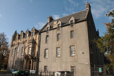
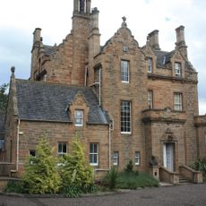
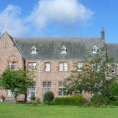
Inch House, Category A listed building in Edinburgh, Scotland.

Description

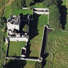
Inch House is an L-shaped tower house from the early 17th century with three floors and an attic, displaying characteristic Scottish architecture of that period. The building combines original features with later alterations across different centuries that have shaped its current form.

History

It was built in 1617 for James Winram and passed to Sir John Gilmour's ownership in 1660 following the Cromwell occupation period. This change in ownership marked a turning point as the property recovered after years of political disruption.

Culture

The name Inch comes from Scottish Gaelic 'innis', meaning dry land near the Braid Burn. Visitors today can see how the building's location relates to the landscape around it and understand its connection to local geography.

Practical

The house sits about 2 miles southeast of Edinburgh's city center and operates as a community center offering multiple spaces for different activities. Getting there works best by public transport or prior planning since it sits away from the main tourist areas.

Did you know?

The entrance displays the Gilmour family crest, marking the house's connection to this prominent Scottish family. Renovations in the 1890s by architects MacGibbon and Ross created an interior courtyard that fundamentally reshaped the building's layout at that time.

Location
GPS coordinates
55.92500,-3.15897
Latest update
December 12, 2025 09:06

AroundUs brings together thousands of curated places, local tips, and hidden gems, enriched daily by 60,000 contributors worldwide. Discover all places nearby (City of Edinburgh).

Around this place
Craigmillar Castle
United Kingdom

Craigmillar Castle

1.1 km
Prestonfield House
United Kingdom

Prestonfield House

1.3 km
EPCC
United Kingdom

EPCC

1 km
Mayfield Salisbury Church
United Kingdom

Mayfield Salisbury Church

1.4 km
Reid Memorial Church
United Kingdom

Reid Memorial Church

1.6 km
Priestfield Parish Church
United Kingdom

Priestfield Parish Church

1.4 km
Edinburgh, Observatory Road, Harrison Memorial Arch
United Kingdom

Edinburgh, Observatory Road, Harrison Memorial Arch

1.4 km
Joseph Black Building
United Kingdom

Joseph Black Building

1.1 km
Abden House
United Kingdom

Abden House

1.5 km
Grant Institute
United Kingdom

Grant Institute

983 m
Edinburgh, 45, 47, 49 Ratcliffe Terrace, Leslie's Bar
United Kingdom

Edinburgh, 45, 47, 49 Ratcliffe Terrace, Leslie's Bar

1.6 km
Liberton Cemetery, Liberton Brae, Edinburgh
United Kingdom

Liberton Cemetery, Liberton Brae, Edinburgh

1.3 km
Hudson Beare Lecture Theatre
United Kingdom

Hudson Beare Lecture Theatre

802 m
Sanderson Building
United Kingdom

Sanderson Building

838 m
Edinburgh, Liberton Brae, Liberton Cemetery, War Memorial
United Kingdom

Edinburgh, Liberton Brae, Liberton Cemetery, War Memorial

1.3 km
Liberton Parish Church, Edinburgh
United Kingdom

Liberton Parish Church, Edinburgh

1.3 km
Ashworth Building
United Kingdom

Ashworth Building

871 m
Crew Building
United Kingdom

Crew Building

1.2 km
Murchison House, King's Buildings, West Mains Road, Edinburgh
United Kingdom

Murchison House, King's Buildings, West Mains Road, Edinburgh

1.3 km
Roger Land Building
United Kingdom

Roger Land Building

1.1 km
Edinburgh And Dalkeith Railway, Duddingston Road West, Braid Burn Bridge
United Kingdom

Edinburgh And Dalkeith Railway, Duddingston Road West, Braid Burn Bridge

1.6 km
Edinburgh, 10 Lasswade Road, Guthrie Court, War Memorial
United Kingdom

Edinburgh, 10 Lasswade Road, Guthrie Court, War Memorial

1.4 km
Edinburgh, 12 Duncan Street
United Kingdom

Edinburgh, 12 Duncan Street

1.6 km
Edinburgh, 10 Lasswade Road, Guthrie Court
United Kingdom

Edinburgh, 10 Lasswade Road, Guthrie Court

1.5 km
South Hall
United Kingdom

South Hall

1.6 km
Royal Blind Asylum And School, West Savile Road, Newington, Edinburgh
United Kingdom

Royal Blind Asylum And School, West Savile Road, Newington, Edinburgh

1.1 km
Designed landscape at Craigmillar Castle
United Kingdom

Designed landscape at Craigmillar Castle

961 m
Darwin Building
United Kingdom

Darwin Building

853 m
Show the full map
« Inch House - Category A listed building in Edinburgh, Scotland » is provided by Around Us (aroundus.com). Images and texts are derived from Wikimedia project under a Creative Commons license. You are allowed to copy, distribute, and modify copies of this page, under the conditions set by the license, as long as this note is clearly visible.

Discover hidden gems everywhere you go!

From secret cafés to breathtaking viewpoints, skip the crowded tourist spots and find places that match your style. Our app makes it easy with voice search, smart filtering, route optimization, and insider tips from travelers worldwide. Download now for the complete mobile experience.

Around Us App Screenshot

A unique approach to discovering new places

Le Figaro

All the places worth exploring

France Info

A tailor-made excursion in just a few clicks

20 Minutes

Around Us
Travel Guide & Maps
Download

Send to your phone

QR Code
1

Open the camera app on your mobile.

2

Point at the QR code with your camera. A notification will appear.

3

Tap the notification to open the link.