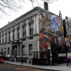
Cable Street Mural, Anti-fascist mural in Tower Hamlets, England
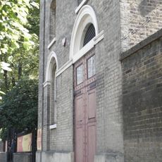
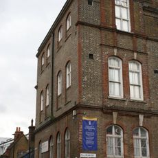
The Cable Street Mural is a large-scale artwork covering the exterior wall of St George's Town Hall, depicting a street confrontation between protesters and police. The composition spans multiple wall sections and uses bold colors with realistic human figures to show different moments of this event.
The mural was created between 1979 and 1983 by four artists and honors an event from 1936 when local residents stopped a fascist march. This street action became a turning point for resistance against political extremism in East London.
The mural represents how Jewish, Irish, and local residents worked side by side to oppose fascist movements in their neighborhood. People today see it as a shared symbol of community resistance that still matters to the area.
The mural is located in a public spot that is easy to access and can be viewed from outside any time, without needing to pay admission. The colors show best during daylight hours, particularly in the morning when sunlight brings out the details of the artwork.
Each figure in the mural is based on real photographs of people who were present at the 1936 event, preserving their actual expressions and gestures. This approach turns the artwork into a visual record of real individuals who took part in that moment.
Location: London Borough of Tower Hamlets
Inception: 1983
Creator: Desmond Rochfort, David Savage, Paul Butler, Ray Walker
GPS coordinates: 51.51100,-0.05864
Latest update: December 8, 2025 19:59
Tobacco Dock
306 m
St George in the East
133 m
St Paul's Church, Shadwell
461 m
East London Central Synagogue
487 m
St Georges Town Hall
16 m
Raine's House
492 m
Shadwell Basin Housing
397 m
Iron Railings, Wall And Iron Gates Of St Paul's Church
465 m
St Paul's Church Church House
445 m
Pennington Street Warehouses (Including Former Canteen And Vaults Below)
409 m
126-130, Cannon Street Road E1
328 m
194-224, Cable Street E1
96 m
K2 Telephone Kiosk At Junction With Sutton Street
485 m
Raine Memorial
105 m
Gate Piers to Church Drive at Church of St George in the East
178 m
230, Cable Street E1
30 m
Darul Ummah Community Centre (Former Lower Chapman Street School) Including Former School Keeper's House, Cookery Block And Playground Shelter
190 m
Anonymous Sarcophagus Approximately 7 Metres East Of St George's Rectory
134 m
192, Cable Street E1
139 m
116-122, Cannon Street Road E1
303 m
St George's Gardens War Memorial
95 m
St George's Rectory
144 m
Monument To A Wyllie In South West Corner Of St Georges Gardens
126 m
300-334, Commercial Road E1
446 m
St Pauls Rectory
429 m
44, Cannon Street Road E1
151 m
Roman Bath House, Shadwell
225 m
Gate Piers To St George In The East's Garden
30 mVisited this place? Tap the stars to rate it and share your experience / photos with the community! Try now! You can cancel it anytime.
Discover hidden gems everywhere you go!
From secret cafés to breathtaking viewpoints, skip the crowded tourist spots and find places that match your style. Our app makes it easy with voice search, smart filtering, route optimization, and insider tips from travelers worldwide. Download now for the complete mobile experience.
A unique approach to discovering new places❞
— Le Figaro
All the places worth exploring❞
— France Info
A tailor-made excursion in just a few clicks❞
— 20 Minutes