Enable Location

We need your location to show you interesting places around you

Discover nearby places

Find interesting locations and hidden gems around you

Precise directions

Get accurate directions and distances to places

Your location is never shared with other users. It's only used when you tap the location button.

St Paul's Church, Shadwell

Log in to your account

Start exploring — it's free

Trusted by 61,622 travelers worldwide

Continue with Google
Continue with Apple
or

We will send you a code to connect

By continuing, you accept our Terms and Conditions and our Privacy Policy

Check your inbox

We've sent a pincode in your inbox. Please enter the code below.

St Paul's Church, Shadwell

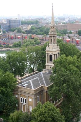
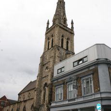
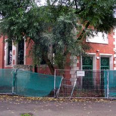
St Paul's Church, Shadwell, Anglican church in Shadwell, England

Description

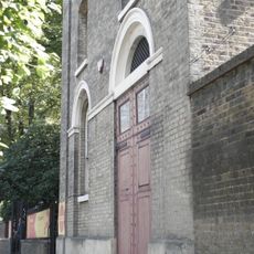
St Paul's Church in Shadwell is a Georgian building located between The Highway and Shadwell Basin, with a symmetrical facade featuring large arched windows. The interior displays classical proportions typical of its period, organized around a central nave that guides the eye toward the altar.

History

The original church was built in 1656 with funding from Thomas Neale and served as one of five burial sites during the Great Plague of London. Over time, it became deeply rooted in the maritime community that grew around the docks.

Culture

The church is known as the Church of Sea Captains because many maritime commanders who departed from London's docks found their final resting place here. Walking through the interior, you can notice the connection to the seafaring world that shaped this neighborhood for centuries.

Practical

The church is accessible to visitors during opening hours, and the interior is straightforward to navigate. It's helpful to check current opening times before visiting, as services may affect public access.

Did you know?

Captain James Cook attended services here, and his eldest son was baptized in the church in 1763, connecting it to one of history's most famous voyages of exploration. This link makes the church a notable part of British maritime heritage.

GPS coordinates
51.50940,-0.05250
Latest update
December 9, 2025 18:47

AroundUs brings together thousands of curated places, local tips, and hidden gems, enriched daily by 60,000 contributors worldwide. Discover all places nearby (London Borough of Tower Hamlets).

Around this place
Prospect of Whitby
United Kingdom

Prospect of Whitby

273 m
Cable Street Mural
United Kingdom

Cable Street Mural

461 m
Wapping Hydraulic Power Station
United Kingdom

Wapping Hydraulic Power Station

301 m
King Edward Memorial Park
United Kingdom

King Edward Memorial Park

247 m
St Georges Town Hall
United Kingdom

St Georges Town Hall

445 m
Shadwell Basin Housing
United Kingdom

Shadwell Basin Housing

89 m
Church of St Mary
United Kingdom

Church of St Mary

240 m
Iron Railings, Wall And Iron Gates Of St Paul's Church
United Kingdom

Iron Railings, Wall And Iron Gates Of St Paul's Church

26 m
St Paul's Church Church House
United Kingdom

St Paul's Church Church House

17 m
5-22 Havering Street and area railings
United Kingdom

5-22 Havering Street and area railings

457 m
Pelican Stairs
United Kingdom

Pelican Stairs

285 m
D Warehouse, Metropolitan Wharf
United Kingdom

D Warehouse, Metropolitan Wharf

337 m
27-45, Havering Street and area railings
United Kingdom

27-45, Havering Street and area railings

457 m
North Block With Attached Railings And Gatepiers Peabody Estate
United Kingdom

North Block With Attached Railings And Gatepiers Peabody Estate

282 m
South Block With Attached Railings And Gatepiers Peabody Estate
United Kingdom

South Block With Attached Railings And Gatepiers Peabody Estate

270 m
East Block With Attached Railings And Gatepiers Peabody Estate
United Kingdom

East Block With Attached Railings And Gatepiers Peabody Estate

310 m
West Block With Attached Railings And Gatepiers Peabody Estate
United Kingdom

West Block With Attached Railings And Gatepiers Peabody Estate

241 m
Glamis Road Bridge
United Kingdom

Glamis Road Bridge

191 m
A Warehouse,Metropolitan Wharf
United Kingdom

A Warehouse,Metropolitan Wharf

309 m
Air Shaft To The Rotherhithe Tunnel
United Kingdom

Air Shaft To The Rotherhithe Tunnel

299 m
New Crane Wharf
United Kingdom

New Crane Wharf

385 m
Shadwell Dock Stairs
United Kingdom

Shadwell Dock Stairs

293 m
E, F, G, H Warehouse, New Crane Wharf
United Kingdom

E, F, G, H Warehouse, New Crane Wharf

412 m
Lusk's Wharf, Lower Oliver's Wharf
United Kingdom

Lusk's Wharf, Lower Oliver's Wharf

362 m
Jubilee Wharf
United Kingdom

Jubilee Wharf

350 m
B And C Warehouse, Metropolitan Wharf
United Kingdom

B And C Warehouse, Metropolitan Wharf

320 m
Roman Bath House, Shadwell
United Kingdom

Roman Bath House, Shadwell

413 m
Gate Piers To St George In The East's Garden
United Kingdom

Gate Piers To St George In The East's Garden

436 m
Show the full map
« St Paul's Church, Shadwell - Anglican church in Shadwell, England » is provided by Around Us (aroundus.com). Images and texts are derived from Wikimedia project under a Creative Commons license. You are allowed to copy, distribute, and modify copies of this page, under the conditions set by the license, as long as this note is clearly visible.

Discover hidden gems everywhere you go!

From secret cafés to breathtaking viewpoints, skip the crowded tourist spots and find places that match your style. Our app makes it easy with voice search, smart filtering, route optimization, and insider tips from travelers worldwide. Download now for the complete mobile experience.

Around Us App Screenshot

A unique approach to discovering new places

Le Figaro

All the places worth exploring

France Info

A tailor-made excursion in just a few clicks

20 Minutes

Around Us
Travel Guide & Maps
Download

Send to your phone

QR Code
1

Open the camera app on your mobile.

2

Point at the QR code with your camera. A notification will appear.

3

Tap the notification to open the link.