Dial House

Log in to your account

AroundUs is a community-driven map of interesting places, built by curious explorers like you. It grows with every review, story, and photo you share.
Connect to save your favorite spots, contribute locations, and create personalized routes.
Continue with Google
Continue with Apple
Continue with X
Continue with Facebook
Continue with email
By continuing, you accept our Terms and Conditions and our Privacy Policy
Create an account
Add to collection
Map
Suggest a change
Share

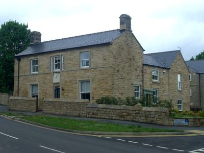
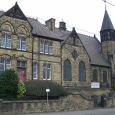
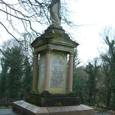
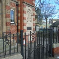
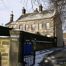
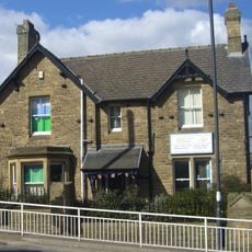
Dial House, Grade II listed building in Wisewood, Sheffield, England.

Dial House is a Grade II listed building in Wisewood, Sheffield, constructed in the 19th century with traditional architectural features and a working sundial positioned above the main entrance. The structure now forms part of a residential development that combines both apartments and houses while retaining its original exterior details.

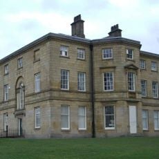
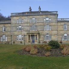
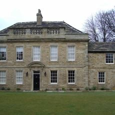
The building was constructed in the 19th century as a country residence and underwent transformation into a social club during the 1930s. After operating for several decades, it was eventually converted back to residential use in the early 2000s.

The building's name comes from the working sundial that marks the facade, a feature that has drawn notice from locals and visitors exploring the neighborhood's older buildings.

The building can be viewed from the public street as it forms part of an active residential area, so you can observe its exterior features freely. The sundial and facade details are best seen during daylight hours when shadows and sunlight enhance their visibility.

The sundial on the facade actually functions and was carefully preserved during restoration work, remaining operational to this day. This working feature makes it one of the few Victorian-era buildings in the neighborhood that still maintains its original timekeeping element.

Location: Sheffield

GPS coordinates: 53.40769,-1.51243

Latest update: December 14, 2025 09:40

Photos
Around this place
Owlerton Stadium
United Kingdom

Owlerton Stadium

1.3 km
Hillsborough House
United Kingdom

Hillsborough House

657 m
Loxley House
United Kingdom

Loxley House

920 m
Burrowlee House
United Kingdom

Burrowlee House

894 m
Sacred Heart Church, Hillsborough
United Kingdom

Sacred Heart Church, Hillsborough

1.1 km
Little Matlock Rolling Mill
United Kingdom

Little Matlock Rolling Mill

1.7 km
Wadsley Parish Church
United Kingdom

Wadsley Parish Church

607 m
Hillsborough Trinity Methodist Church
United Kingdom

Hillsborough Trinity Methodist Church

556 m
Walkley Library
United Kingdom

Walkley Library

1.6 km
Church of St John The Baptist And Attached Boundary Wall And Gates
United Kingdom

Church of St John The Baptist And Attached Boundary Wall And Gates

1.1 km
Yorkshire Natural History Museum
United Kingdom

Yorkshire Natural History Museum

873 m
Church At Middlewood Hospital
United Kingdom

Church At Middlewood Hospital

1.1 km
St Michaels Cemetery Chapel
United Kingdom

St Michaels Cemetery Chapel

1.8 km
Cupola Contemporary Arts
United Kingdom

Cupola Contemporary Arts

650 m
Monument And Railings To Gh Foster 7 Metres West Of St Michaels Cemetery Chapel
United Kingdom

Monument And Railings To Gh Foster 7 Metres West Of St Michaels Cemetery Chapel

1.8 km
Hollins Bridge
United Kingdom

Hollins Bridge

1.7 km
Walsh Monument And Railing At Rivelin Glen Cemetery
United Kingdom

Walsh Monument And Railing At Rivelin Glen Cemetery

1.8 km
Owlerton War Memorial Hall
United Kingdom

Owlerton War Memorial Hall

1.1 km
Wadsley Hall And Adjoining Barns And Stables
United Kingdom

Wadsley Hall And Adjoining Barns And Stables

310 m
K6 Telephone Kiosk 30 Metres Left Of Walkley And Hillsborough District Baths
United Kingdom

K6 Telephone Kiosk 30 Metres Left Of Walkley And Hillsborough District Baths

1.1 km
Wardsend Viaduct
United Kingdom

Wardsend Viaduct

1.4 km
Hillsborough Park Cinema
United Kingdom

Hillsborough Park Cinema

699 m
Milepost Approximately 50 Metres North Of Junction With Stockarth Lane
United Kingdom

Milepost Approximately 50 Metres North Of Junction With Stockarth Lane

1.8 km
Hillsborough House And Attached Boundary Walls, Railings And Outbuildings
United Kingdom

Hillsborough House And Attached Boundary Walls, Railings And Outbuildings

632 m
Coach House And Stable 20 Metres North West Of Hillsborough Hall
United Kingdom

Coach House And Stable 20 Metres North West Of Hillsborough Hall

622 m
Sewer Gas Lamp 15 Metres South Of Number 237 (Number 237 Not Included)
United Kingdom

Sewer Gas Lamp 15 Metres South Of Number 237 (Number 237 Not Included)

812 m
Sewer Gas Lamp at Junction with Portsea Road
United Kingdom

Sewer Gas Lamp at Junction with Portsea Road

496 m
Milestone, jct Middlewood Road and Catchbar Lane
United Kingdom

Milestone, jct Middlewood Road and Catchbar Lane

674 m
Show the full map
Reviews

Visited this place? Tap the stars to rate it and share your experience / photos with the community! Try now! You can cancel it anytime.

« Dial House - Grade II listed building in Wisewood, Sheffield, England » is provided by Around Us (aroundus.com). Images and texts are derived from Wikimedia project under a Creative Commons license. You are allowed to copy, distribute, and modify copies of this page, under the conditions set by the license, as long as this note is clearly visible.

Discover hidden gems everywhere you go!

From secret cafés to breathtaking viewpoints, skip the crowded tourist spots and find places that match your style. Our app makes it easy with voice search, smart filtering, route optimization, and insider tips from travelers worldwide. Download now for the complete mobile experience.

Around Us App Screenshot

A unique approach to discovering new places

Le Figaro

All the places worth exploring

France Info

A tailor-made excursion in just a few clicks

20 Minutes