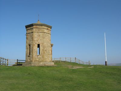
The Storm Tower, Grade II listed octagonal tower in Bude, England
The Storm Tower is an octagonal tower built from roughly dressed stone, with precisely cut corner quoins and narrow slit openings on each face, standing near the coast of Bude in Cornwall, England. It is a Grade II listed building, meaning it carries official recognition as a structure of special interest.
The tower was designed in 1835 by architect George Wightwick for Sir Thomas Dyke Acland, drawing on classical models including the Tower of the Winds in Athens. It received Grade II listed status in 1985, giving it formal protection under heritage law.
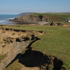
The tower's name reflects the fierce storms that batter this stretch of coast, and that maritime identity still shapes how people see this part of Cornwall. Walking around the site, you notice how the raw coastal setting gives the structure a weight and presence that goes beyond its modest size.
The tower was moved inland in 2023 and 2024 to protect it from coastal erosion, so its current position may differ from older maps and guides. The coastal area can be exposed and conditions change with the weather, so it is worth checking access before you visit.
Each of the tower's eight faces carries a carved compass rose marking the cardinal directions, but magnetic drift has shifted the original alignment by around seven degrees over the decades. Most visitors walk past without noticing, yet this small detail shows how even stone structures are affected by forces you cannot see.
The community of curious travelers
AroundUs brings together thousands of curated places, local tips, and hidden gems, enriched daily by 60,000 contributors worldwide.