Enable Location

We need your location to show you interesting places around you

Discover nearby places

Find interesting locations and hidden gems around you

Precise directions

Get accurate directions and distances to places

Your location is never shared with other users. It's only used when you tap the location button.

Auglaize County

Log in to your account

Start exploring — it's free

Trusted by 61,863 travelers worldwide

Continue with Google
Continue with Apple
or

We will send you a code to connect

By continuing, you accept our Terms and Conditions and our Privacy Policy

Check your inbox

We've sent a pincode in your inbox. Please enter the code below.

Auglaize County, County seat in northwestern Ohio, United States.

Description

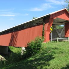
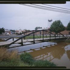
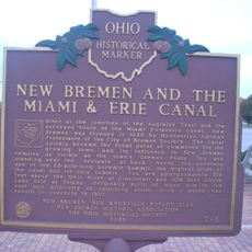
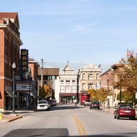
Auglaize County is an administrative division in northwestern Ohio with Wapakoneta serving as the county seat. The Auglaize River and Miami-Erie Canal run through the area, which covers approximately 402 square miles.

History

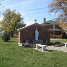
The county was officially established on February 14, 1848, making it one of Ohio's smallest by area. It grew from early French and American settlements focused on trade and agriculture.

Culture

The name comes from French or Native American roots, possibly referring to clay water or fallen timber, which shaped how locals understand their surroundings. You can see this heritage reflected in the names of waterways and communities throughout the area.

Practical

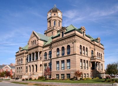
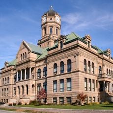
County services and government offices are located at the Berea sandstone courthouse built in 1894, serving as the central hub in Wapakoneta. Visitors can access administrative services during standard business hours at this location.

Did you know?

Three major rivers – the Saint Marys, Great Miami, and Scioto – have their headwaters within the county, shaping the region's water landscape. These source waters make the area a crucial point in regional hydrology.

Location
Inception
February 14, 1848
Capital city
Wapakoneta
Shares border with
Allen County, Shelby County, Mercer County, Darke County, Logan County, Hardin County, Van Wert County
GPS coordinates
40.56000,-84.22000
Latest update
December 7, 2025 10:06

AroundUs brings together thousands of curated places, local tips, and hidden gems, enriched daily by 60,000 contributors worldwide. Discover all places nearby (Ohio).

Around this place
Neil Armstrong Air and Space Museum
United States of America

Neil Armstrong Air and Space Museum

4.2 km
J.H. Manchester Round Barn
United States of America

J.H. Manchester Round Barn

27.8 km
St. Joseph's Catholic Church
United States of America

St. Joseph's Catholic Church

2.3 km
Sacred Heart Catholic Church
United States of America

Sacred Heart Catholic Church

18.7 km
St. Patrick's Catholic Church
United States of America

St. Patrick's Catholic Church

21.9 km
Immaculate Conception Catholic Church
United States of America

Immaculate Conception Catholic Church

10.6 km
Auglaize County Courthouse
United States of America

Auglaize County Courthouse

2.4 km
McColly Covered Bridge
United States of America

McColly Covered Bridge

30.7 km
Adolph Boesel House
United States of America

Adolph Boesel House

19.7 km
Julius Boesel House
United States of America

Julius Boesel House

18.2 km
Griffith Breese Farm
United States of America

Griffith Breese Farm

16.7 km
William Luelleman House
United States of America

William Luelleman House

19.2 km
Emanuel Lutheran Church of Montra
United States of America

Emanuel Lutheran Church of Montra

17.9 km
H.E. Fledderjohann Property
United States of America

H.E. Fledderjohann Property

11 km
Anna Town Hall
United States of America

Anna Town Hall

18.8 km
Neely-Sieber House
United States of America

Neely-Sieber House

21.8 km
Uniopolis Town Hall
United States of America

Uniopolis Town Hall

12.1 km
John H. Nichols House
United States of America

John H. Nichols House

2.3 km
Dr. Issac Elmer Williams House and Office
United States of America

Dr. Issac Elmer Williams House and Office

14.7 km
Lima Cleaning and Pressing Company Building
United States of America

Lima Cleaning and Pressing Company Building

21.8 km
Hugh T. Rinehart House
United States of America

Hugh T. Rinehart House

16.5 km
Charles Wintzer Building
United States of America

Charles Wintzer Building

2.3 km
First Presbyterian Church of Wapakoneta
United States of America

First Presbyterian Church of Wapakoneta

2.3 km
Bicycle Museum of America
United States of America

Bicycle Museum of America

19.3 km
Blackhoof Street Bridge
United States of America

Blackhoof Street Bridge

19.4 km
The Miami & Erie Canal and New Bremen
United States of America

The Miami & Erie Canal and New Bremen

19.3 km
Lois Lenski
United States of America

Lois Lenski

18.4 km
Sandy Beach Amusement Park
United States of America

Sandy Beach Amusement Park

29.1 km
Show the full map
Administrative divisions
« Auglaize County - County seat in northwestern Ohio, United States » is provided by Around Us (aroundus.com). Images and texts are derived from Wikimedia project under a Creative Commons license. You are allowed to copy, distribute, and modify copies of this page, under the conditions set by the license, as long as this note is clearly visible.

Discover hidden gems everywhere you go!

From secret cafés to breathtaking viewpoints, skip the crowded tourist spots and find places that match your style. Our app makes it easy with voice search, smart filtering, route optimization, and insider tips from travelers worldwide. Download now for the complete mobile experience.

Around Us App Screenshot

A unique approach to discovering new places

Le Figaro

All the places worth exploring

France Info

A tailor-made excursion in just a few clicks

20 Minutes

Around Us
Travel Guide & Maps
Download

Send to your phone

QR Code
1

Open the camera app on your mobile.

2

Point at the QR code with your camera. A notification will appear.

3

Tap the notification to open the link.