Enable Location

We need your location to show you interesting places around you

Discover nearby places

Find interesting locations and hidden gems around you

Precise directions

Get accurate directions and distances to places

Your location is never shared with other users. It's only used when you tap the location button.

J.H. Manchester Round Barn

Log in to your account

Start exploring — it's free

Trusted by 62,849 travelers worldwide

Continue with Google
Continue with Apple
or

We will send you a code to connect

By continuing, you accept our Terms and Conditions and our Privacy Policy

Check your inbox

We've sent a pincode in your inbox. Please enter the code below.

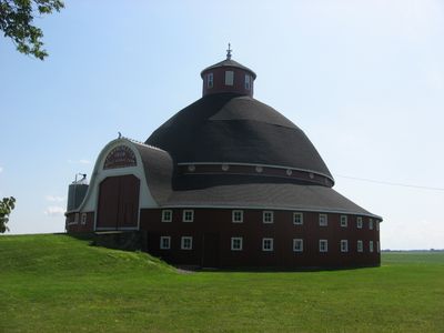
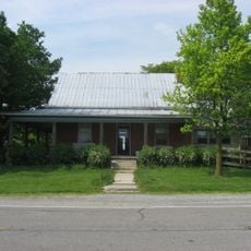
J.H. Manchester Round Barn, Round barn on State Route 385 near Waynesfield, Ohio.

The wooden structure rises 88 feet (27 meters) with a diameter of 102 feet (31 meters), incorporating double-hinged entrance doors and a domed gambrel roof covered in traditional shingles with central ventilation systems for hay storage.

Horace Duncan constructed the barn in 1908 for Jason Manchester during a period when Ohio farmers experimented with alternative building forms to improve productivity, and the property has remained with the Manchester family through successive generations since completion.

The structure served as a model for progressive farm management in rural Ohio communities, with its design reducing labor requirements through efficient feed distribution from the central core to animals housed along the outer walls.

The barn remains under private ownership by the Manchester family, and visitors may observe architectural details from the adjacent gravel driveway without entering the property or disturbing ongoing farming operations.

This property forms part of a collection with six neighboring round barns, creating the largest concentration of such agricultural structures in this region of Ohio and representing an unusual example of early twentieth-century experimental farm architecture.

The community of curious travelers

AroundUs brings together thousands of curated places, local tips, and hidden gems, enriched daily by 60,000 contributors worldwide.

Start exploring
Location
GPS coordinates
40.55878,-83.89158
Latest update
November 28, 2025 22:44
Around this place
Indian Lake
United States of America

Indian Lake

10.3 km
Neil Armstrong Air and Space Museum
United States of America

Neil Armstrong Air and Space Museum

23.6 km
Dunns Pond Mound
United States of America

Dunns Pond Mound

9.6 km
Zimmerman Kame
United States of America

Zimmerman Kame

6.3 km
Lake Ridge Island Mounds
United States of America

Lake Ridge Island Mounds

8 km
McColly Covered Bridge
United States of America

McColly Covered Bridge

17.8 km
Emanuel Lutheran Church of Montra
United States of America

Emanuel Lutheran Church of Montra

22.2 km
Uniopolis Town Hall
United States of America

Uniopolis Town Hall

17.3 km
Hugh T. Rinehart House
United States of America

Hugh T. Rinehart House

12.8 km
United States of America

Indian Lake State Park

8.9 km
United States of America

Ohio State University Observatory

22.7 km
Bickham Covered Bridge
United States of America

Bickham Covered Bridge

10.3 km
Sandy Beach Amusement Park
United States of America

Sandy Beach Amusement Park

9.6 km
Ohio Northern University
United States of America

Ohio Northern University

23.7 km
United States of America

Cherokee Hills Golf Course

18.6 km
United States of America

Colonial Golfers Club

19.7 km
United States of America

Prairie View Golf Club

6 km
United States of America

Haunted Town Hall

22.8 km
United States of America

Freed Center for the Performing Arts

23.6 km
United States of America

Amphitheater

23.8 km

Elzay Gallery of Art

23.8 km
United States of America

Fox Island Beach

9.2 km
United States of America

Water Slide

23.7 km
United States of America

Sun Valley Family Campground

14 km
United States of America

Sculpture, Work of art

23.9 km
United States of America

Work of art, sculpture

23.7 km
United States of America

Statue, Work of art

23.8 km
United States of America

Douglas F5D Skylancer

23.8 km
Show the full map
« J.H. Manchester Round Barn - Round barn on State Route 385 near Waynesfield, Ohio » is provided by Around Us (aroundus.com). Images and texts are derived from Wikimedia project under a Creative Commons license. You are allowed to copy, distribute, and modify copies of this page, under the conditions set by the license, as long as this note is clearly visible.

Discover hidden gems everywhere you go!

From secret cafés to breathtaking viewpoints, skip the crowded tourist spots and find places that match your style. Our app makes it easy with voice search, smart filtering, route optimization, and insider tips from travelers worldwide. Download now for the complete mobile experience.

Around Us App Screenshot

A unique approach to discovering new places

Le Figaro

All the places worth exploring

France Info

A tailor-made excursion in just a few clicks

20 Minutes

Around Us
Travel Guide & Maps
Download

Send to your phone

QR Code
1

Open the camera app on your mobile.

2

Point at the QR code with your camera. A notification will appear.

3

Tap the notification to open the link.