Chest opened
+${chestReward.xp} XP
Explorer
NOUVEAU ×${chestReward.collectible.quantity}
tapez pour fermer
Chest locked

Open chests in the app

Around Us is built for your phone — chests unlock when you walk, explore and capture nearby places.

Enable Location

We need your location to show you interesting places around you

Discover nearby places

Find interesting locations and hidden gems around you

Precise directions

Get accurate directions and distances to places

Your location is never shared with other users. It's only used when you tap the location button.

Hawkeye Point

Log in to your account

Start exploring — it's free

Trusted by 72,884 travelers worldwide

Continue with Google
Continue with Apple
or

We will send you a code to connect

By continuing, you accept our Terms and Conditions and our Privacy Policy

Check your inbox

We've sent a pincode in your inbox. Please enter the code below.

Hawkeye Point
Discussion Reviews 2 Photos
22.4k Popularity

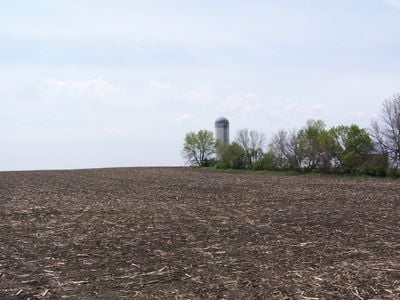
Hawkeye Point, Natural elevation point in Osceola County, Iowa, United States.

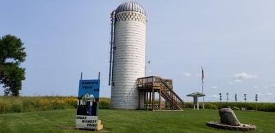
Hawkeye Point is a natural elevation in Osceola County that rises roughly 20 feet above the surrounding agricultural fields of northern Iowa. The location features a grain bin shelter, an observation silo, and informational displays for visitors.

The Sterler family owned the land until 2007, when Osceola County purchased five acres to secure permanent public access. This acquisition made Iowa's highest point accessible to all visitors.

Over the years, visitors have left license plates from their home states, which are displayed at the information kiosk. This tradition has turned the location into a personal gathering place where nearly every state is represented.

The location sits in flat farmland and is straightforward to reach, with parking available near the elevation. For those who wish to stay overnight, twelve camping spots with electrical and water connections are available.

Directional markers at the summit show the distance and direction to each of the other 49 state high points across the country. These markers create an unexpected connection between this location and the highest points throughout the nation.

The community of curious travelers

AroundUs brings together thousands of curated places, local tips, and hidden gems, enriched daily by 60,000 contributors worldwide.

Start exploring
Location
Elevation above the sea
509 m
GPS coordinates
43.46000,-95.70890
Latest update
December 20, 2025 16:17
Around this place
West Okoboji Lake
United States of America

West Okoboji Lake

45.2 km
United States of America

Spirit Lake Massacre

49.4 km
Blue Mounds State Park
United States of America

Blue Mounds State Park

48.2 km
United States of America

Gull Point State Park

45.1 km
First Reformed Church
United States of America

First Reformed Church

57.5 km
Pillsbury Point State Park
United States of America

Pillsbury Point State Park

47.1 km
Spirit Lake Massacre Log Cabin
United States of America

Spirit Lake Massacre Log Cabin

47.1 km
George D. Dayton House
United States of America

George D. Dayton House

20.4 km
Carnegie Library
United States of America

Carnegie Library

33.3 km
Church of St. Kilian
United States of America

Church of St. Kilian

38.8 km
Clay County Courthouse
United States of America

Clay County Courthouse

57.6 km
Dickinson County Courthouse
United States of America

Dickinson County Courthouse

49.1 km
O'Brien County Courthouse
United States of America

O'Brien County Courthouse

42.1 km
Melan Bridge
United States of America

Melan Bridge

36.1 km
Osceola County Courthouse
United States of America

Osceola County Courthouse

7.2 km
Church of St. Adrian-Catholic
United States of America

Church of St. Adrian-Catholic

26.4 km
Lyon County Courthouse
United States of America

Lyon County Courthouse

37.2 km
Holy Trinity Church-Episcopal
United States of America

Holy Trinity Church-Episcopal

46 km
Old Spirit Lake Public Library
United States of America

Old Spirit Lake Public Library

49.2 km
Sacred Heart Catholic Church
United States of America

Sacred Heart Catholic Church

48.8 km
Gerome Clark House
United States of America

Gerome Clark House

53.8 km
Blue Mounds State Park WPA/Rustic Style Historic Resources
United States of America

Blue Mounds State Park WPA/Rustic Style Historic Resources

47.9 km
Pearson Lakes Art Center
United States of America

Pearson Lakes Art Center

47.5 km
Abbie Gardner Cabin
United States of America

Abbie Gardner Cabin

47.1 km
Superior 71 Drive-In
United States of America

Superior 71 Drive-In

57.9 km
Avoca Historical Marker
United States of America

Avoca Historical Marker

54.6 km
Palace Theatre
United States of America

Palace Theatre

45.8 km
Memorial Park
United States of America

Memorial Park

46.7 km
Show the full map
Reviews
Share your experience

No review yet

Discussions
Start a discussion...

No discussion yet

« Hawkeye Point - Natural elevation point in Osceola County, Iowa, United States » is provided by Around Us (aroundus.com). Images and texts are derived from Wikimedia project under a Creative Commons license. You are allowed to copy, distribute, and modify copies of this page, under the conditions set by the license, as long as this note is clearly visible.

Discover hidden gems everywhere you go!

From secret cafés to breathtaking viewpoints, skip the crowded tourist spots and find places that match your style. Our app makes it easy with voice search, smart filtering, route optimization, and insider tips from travelers worldwide. Download now for the complete mobile experience.

Around Us App Screenshot

A unique approach to discovering new places

Le Figaro

All the places worth exploring

France Info

A tailor-made excursion in just a few clicks

20 Minutes

Around Us
Travel Guide & Maps
Download

Send to your phone

QR Code
1

Open the camera app on your mobile.

2

Point at the QR code with your camera. A notification will appear.

3

Tap the notification to open the link.