Chest opened
+${chestReward.xp} XP
Explorer
NOUVEAU ×${chestReward.collectible.quantity}
tapez pour fermer
Chest locked

Open chests in the app

Around Us is built for your phone — chests unlock when you walk, explore and capture nearby places.

Enable Location

We need your location to show you interesting places around you

Discover nearby places

Find interesting locations and hidden gems around you

Precise directions

Get accurate directions and distances to places

Your location is never shared with other users. It's only used when you tap the location button.

Mahoning River

Log in to your account

Start exploring — it's free

Trusted by 72,889 travelers worldwide

Continue with Google
Continue with Apple
or

We will send you a code to connect

By continuing, you accept our Terms and Conditions and our Privacy Policy

Check your inbox

We've sent a pincode in your inbox. Please enter the code below.

Mahoning River
Discussion Reviews 1 Photos
9.5k Popularity

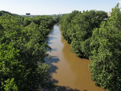
Mahoning River, River system in northeastern Ohio and western Pennsylvania, United States.

The Mahoning River is a river system that flows across northeastern Ohio and western Pennsylvania. The waterway passes through multiple counties before emptying into the Ohio River, creating an important connection in the regional water network.

The river takes its name from Native American peoples who valued salt springs along its banks for preserving food and other needs. These natural resources were critical to indigenous communities long before the region experienced rapid industrial growth.

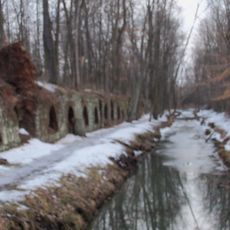
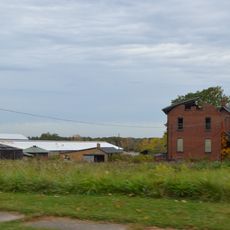
The river shaped industrial cities along its course, with steel mills defining the identity and daily rhythms of communities like Youngstown for much of the 1900s. Today, its banks still reflect this heritage through the presence of former factory structures and the way locals connect to the water's industrial past.

The river is regulated by several dams that manage water flow and affect access to different sections. Visitors should check local conditions before visiting, as water levels and accessibility can vary depending on the season and weather.

The waterway once carried extremely heavy industrial pollution from nearby factories, making it one of the most degraded rivers in the region. Current restoration efforts are gradually improving water quality and fish habitat along the entire course.

The community of curious travelers

AroundUs brings together thousands of curated places, local tips, and hidden gems, enriched daily by 60,000 contributors worldwide.

Start exploring
Location
Location
GPS coordinates
40.82173,-80.90342
Latest update
December 10, 2025 15:57
Around this place
Cherry Valley Coke Ovens
United States of America

Cherry Valley Coke Ovens

13.6 km
Kendal, Ohio
United States of America

Kendal, Ohio

22.4 km
Columbiana County Courthouse
United States of America

Columbiana County Courthouse

12.8 km
Daniel Howell Hise House
United States of America

Daniel Howell Hise House

9.4 km
Teegarden-Centennial Covered Bridge
United States of America

Teegarden-Centennial Covered Bridge

6.4 km
John Street House
United States of America

John Street House

10 km
Haines House
United States of America

Haines House

20.7 km
Burchfield Homestead
United States of America

Burchfield Homestead

10.3 km
Church Hill Road Covered Bridge
United States of America

Church Hill Road Covered Bridge

15.5 km
First United Methodist Church
United States of America

First United Methodist Church

9.5 km
Lisbon Historic District
United States of America

Lisbon Historic District

12.4 km
Hanoverton Canal Town District
United States of America

Hanoverton Canal Town District

8.2 km
Alliance Bank Building
United States of America

Alliance Bank Building

19.8 km
Charles Nelson Schmick House
United States of America

Charles Nelson Schmick House

13.7 km
John Herrington House and Herrington Bethel Church
United States of America

John Herrington House and Herrington Bethel Church

21.3 km
Middle Sandy Presbyterian Church
United States of America

Middle Sandy Presbyterian Church

14.1 km
South Lincoln Avenue Historic District
United States of America

South Lincoln Avenue Historic District

9.4 km
Alliance Clay Product Company
United States of America

Alliance Clay Product Company

17.6 km
Hanna-Kenty House
United States of America

Hanna-Kenty House

12.5 km
Eagles Building-Strand Theater
United States of America

Eagles Building-Strand Theater

20.1 km
First Methodist Episcopal Church
United States of America

First Methodist Episcopal Church

19.8 km
Patrick Hull House
United States of America

Patrick Hull House

24.8 km
Hiram Bell Farmstead
United States of America

Hiram Bell Farmstead

19.2 km
Jones-Bowman House
United States of America

Jones-Bowman House

19.5 km
Nicholas Eckis House
United States of America

Nicholas Eckis House

22.5 km
Funtimes Fun Park
United States of America

Funtimes Fun Park

23.9 km
Haines House Underground Railroad Museum
United States of America

Haines House Underground Railroad Museum

20.6 km
Canfield Township Hall
United States of America

Canfield Township Hall

25.6 km
Show the full map
Reviews
Share your experience

No review yet

Discussions
Start a discussion...

No discussion yet

« Mahoning River - River system in northeastern Ohio and western Pennsylvania, United States » is provided by Around Us (aroundus.com). Images and texts are derived from Wikimedia project under a Creative Commons license. You are allowed to copy, distribute, and modify copies of this page, under the conditions set by the license, as long as this note is clearly visible.

Discover hidden gems everywhere you go!

From secret cafés to breathtaking viewpoints, skip the crowded tourist spots and find places that match your style. Our app makes it easy with voice search, smart filtering, route optimization, and insider tips from travelers worldwide. Download now for the complete mobile experience.

Around Us App Screenshot

A unique approach to discovering new places

Le Figaro

All the places worth exploring

France Info

A tailor-made excursion in just a few clicks

20 Minutes

Around Us
Travel Guide & Maps
Download

Send to your phone

QR Code
1

Open the camera app on your mobile.

2

Point at the QR code with your camera. A notification will appear.

3

Tap the notification to open the link.