Enable Location

We need your location to show you interesting places around you

Discover nearby places

Find interesting locations and hidden gems around you

Precise directions

Get accurate directions and distances to places

Your location is never shared with other users. It's only used when you tap the location button.

Teegarden-Centennial Covered Bridge

Log in to your account

Start exploring — it's free

Trusted by 61,865 travelers worldwide

Continue with Google
Continue with Apple
or

We will send you a code to connect

By continuing, you accept our Terms and Conditions and our Privacy Policy

Check your inbox

We've sent a pincode in your inbox. Please enter the code below.

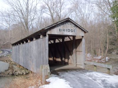
Teegarden-Centennial Covered Bridge, Historic covered bridge in Columbiana County, United States.

Description

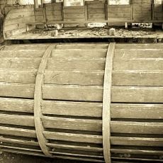
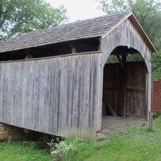
The Teegarden-Centennial Covered Bridge is a white oak structure with multiple king posts spanning 67 feet across the Middle Fork of Little Beaver Creek on Eagleton Road near Salem. The structure displays the characteristic wooden construction techniques typical of its era, with its distinctive timber framing visible throughout.

History

Built in 1876 by architect Jeremiah C. Mountz, the bridge was named after landowner U. Teegarden during the United States centennial year. It represents one of very few survivors from a time when hundreds of covered bridges stood throughout the county.

Culture

The bridge served as a baptismal site for members of Highland Christian Church, making it a spiritual landmark for the local community. People still associate this structure with religious ceremonies and gatherings that connected faith to everyday life in the region.

Practical

The bridge is open exclusively for pedestrian use since 1992, when vehicle traffic was diverted to a newer concrete bridge. Visitors can walk across the structure and enjoy the surrounding creek setting on foot.

Did you know?

Only five covered bridges remain from an original collection of over 250 that once existed throughout Columbiana County. This dramatic decline shows how few such structures have survived to the present day.

GPS coordinates
40.82170,-80.82720
Latest update
December 14, 2025 16:42

AroundUs brings together thousands of curated places, local tips, and hidden gems, enriched daily by 60,000 contributors worldwide. Discover all places nearby (Columbiana County).

Around this place
Beaver Creek State Park
United States of America

Beaver Creek State Park

21 km
Cherry Valley Coke Ovens
United States of America

Cherry Valley Coke Ovens

8.9 km
Columbiana County Courthouse
United States of America

Columbiana County Courthouse

7.5 km
Daniel Howell Hise House
United States of America

Daniel Howell Hise House

8 km
Gaston's Mill-Lock No. 36, Sandy and Beaver Canal District
United States of America

Gaston's Mill-Lock No. 36, Sandy and Beaver Canal District

20.9 km
John Street House
United States of America

John Street House

9.6 km
Burchfield Homestead
United States of America

Burchfield Homestead

9.4 km
Church Hill Road Covered Bridge
United States of America

Church Hill Road Covered Bridge

9.5 km
First United Methodist Church
United States of America

First United Methodist Church

8.9 km
Lisbon Historic District
United States of America

Lisbon Historic District

7.3 km
Hanoverton Canal Town District
United States of America

Hanoverton Canal Town District

12 km
Alliance Bank Building
United States of America

Alliance Bank Building

25.4 km
Charles Nelson Schmick House
United States of America

Charles Nelson Schmick House

8.6 km
John Herrington House and Herrington Bethel Church
United States of America

John Herrington House and Herrington Bethel Church

24.8 km
Middle Sandy Presbyterian Church
United States of America

Middle Sandy Presbyterian Church

20.5 km
Columbiana County Infirmary
United States of America

Columbiana County Infirmary

4.9 km
South Lincoln Avenue Historic District
United States of America

South Lincoln Avenue Historic District

8.5 km
Alliance Clay Product Company
United States of America

Alliance Clay Product Company

23.3 km
Daniel McBean Farmstead
United States of America

Daniel McBean Farmstead

23.5 km
Hanna-Kenty House
United States of America

Hanna-Kenty House

6.8 km
First Methodist Episcopal Church
United States of America

First Methodist Episcopal Church

25.4 km
Hiram Bell Farmstead
United States of America

Hiram Bell Farmstead

12.8 km
Jones-Bowman House
United States of America

Jones-Bowman House

13.7 km
Nicholas Eckis House
United States of America

Nicholas Eckis House

16.1 km
Canfield Township Hall
United States of America

Canfield Township Hall

23.2 km
Birthplace of Catholicism in Northern Ohio
United States of America

Birthplace of Catholicism in Northern Ohio

10.7 km
Thomas J. Malone Bridge
United States of America

Thomas J. Malone Bridge

21 km
Teegarden-Centennial Covered Bridge
United States of America

Teegarden-Centennial Covered Bridge

36 m
Show the full map
« Teegarden-Centennial Covered Bridge - Historic covered bridge in Columbiana County, United States » is provided by Around Us (aroundus.com). Images and texts are derived from Wikimedia project under a Creative Commons license. You are allowed to copy, distribute, and modify copies of this page, under the conditions set by the license, as long as this note is clearly visible.

Discover hidden gems everywhere you go!

From secret cafés to breathtaking viewpoints, skip the crowded tourist spots and find places that match your style. Our app makes it easy with voice search, smart filtering, route optimization, and insider tips from travelers worldwide. Download now for the complete mobile experience.

Around Us App Screenshot

A unique approach to discovering new places

Le Figaro

All the places worth exploring

France Info

A tailor-made excursion in just a few clicks

20 Minutes

Around Us
Travel Guide & Maps
Download

Send to your phone

QR Code
1

Open the camera app on your mobile.

2

Point at the QR code with your camera. A notification will appear.

3

Tap the notification to open the link.