Beaver Creek State Park

Log in to your account

AroundUs is a community-driven map of interesting places, built by curious explorers like you. It grows with every review, story, and photo you share.
Connect to save your favorite spots, contribute locations, and create personalized routes.
Continue with Google
Continue with Apple
Continue with X
Continue with Facebook
Continue with email
By continuing, you accept our Terms and Conditions and our Privacy Policy
Create an account
Add to collection
Map
Suggest a change
Share

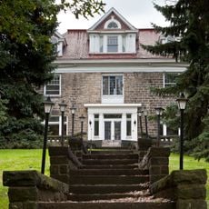
Beaver Creek State Park, State park and museum in Columbiana County, Ohio, United States

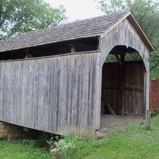
Beaver Creek State Park is a museum and state park in Columbiana County featuring a sandstone gorge carved by Little Beaver Creek, with steep cliffs and hardwood forests covering the landscape. The property offers camping areas, fishing spots, and extensive walking trails alongside a working historic mill.

The Sandy and Beaver Canal was constructed in 1848 to transport goods through the region but closed four years later in 1852. The waterway marked an important era in local commerce before railroads became the dominant transport method.

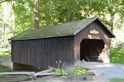
Gaston's Mill, built in 1837, still produces whole wheat flour, corn meal, and buckwheat flour using traditional stone grinding methods. The working mill demonstrates techniques passed down through generations and reflects local self-sufficiency practices.

The park is open year-round with fishing areas, camping grounds, and walking trails ranging from easy to challenging. Wear sturdy footwear because paths can be steep and trail conditions vary by season.

Lusk's Lock is the largest remaining canal structure and features a distinctive double-curved stone staircase that demonstrates uncommon engineering techniques of its time. This remarkable construction method was rarely replicated elsewhere.

Location: Ohio

Inception: 1949

Website: https://ohiodnr.gov/wps/portal/gov/odnr/go-and-do/plan-a-visit/find-a-property/beaver-creek-state-park

GPS coordinates: 40.72690,-80.61250

Latest update: December 9, 2025 18:48

Photos
Around this place
Beginning Point of the U.S. Public Land Survey
United States of America

Beginning Point of the U.S. Public Land Survey

12.3 km
Jennings Randolph Bridge
United States of America

Jennings Randolph Bridge

12.7 km
Newell Toll Bridge
United States of America

Newell Toll Bridge

12.1 km
Richard L. Cawood Residence
United States of America

Richard L. Cawood Residence

9.8 km
Museum of Ceramics
United States of America

Museum of Ceramics

12.4 km
Carnegie Public Library
United States of America

Carnegie Public Library

12.5 km
Watts Mill Bridge
United States of America

Watts Mill Bridge

12.3 km
Gaston's Mill-Lock No. 36, Sandy and Beaver Canal District
United States of America

Gaston's Mill-Lock No. 36, Sandy and Beaver Canal District

71 m
Cassius Clark Thompson House
United States of America

Cassius Clark Thompson House

12.7 km
Diamond Historic District
United States of America

Diamond Historic District

12.4 km
Ikirt House
United States of America

Ikirt House

12.1 km
Church Hill Road Covered Bridge
United States of America

Church Hill Road Covered Bridge

11.6 km
Salem Downtown Historic District
United States of America

Salem Downtown Historic District

9.8 km
Mary A. Patterson Memorial
United States of America

Mary A. Patterson Memorial

12.5 km
Potters National Bank
United States of America

Potters National Bank

12.6 km
William E. Wells House
United States of America

William E. Wells House

12.5 km
YMCA
United States of America

YMCA

12.5 km
Potters Savings and Loan
United States of America

Potters Savings and Loan

12.4 km
East Fifth Street Historic District
United States of America

East Fifth Street Historic District

12.4 km
Elks Club
United States of America

Elks Club

12.2 km
City Hall
United States of America

City Hall

12.2 km
Godwin-Knowles House
United States of America

Godwin-Knowles House

12.5 km
Homer Laughlin House
United States of America

Homer Laughlin House

12.5 km
Hiram Bell Farmstead
United States of America

Hiram Bell Farmstead

11.3 km
Nicholas Eckis House
United States of America

Nicholas Eckis House

10.8 km
Chester Bridge
United States of America

Chester Bridge

13 km
Odd Fellows Temple
United States of America

Odd Fellows Temple

12.1 km
Thomas J. Malone Bridge
United States of America

Thomas J. Malone Bridge

16 m
Show the full map
Reviews

Visited this place? Tap the stars to rate it and share your experience / photos with the community! Try now! You can cancel it anytime.

« Beaver Creek State Park - State park and museum in Columbiana County, Ohio, United States » is provided by Around Us (aroundus.com). Images and texts are derived from Wikimedia project under a Creative Commons license. You are allowed to copy, distribute, and modify copies of this page, under the conditions set by the license, as long as this note is clearly visible.

Discover hidden gems everywhere you go!

From secret cafés to breathtaking viewpoints, skip the crowded tourist spots and find places that match your style. Our app makes it easy with voice search, smart filtering, route optimization, and insider tips from travelers worldwide. Download now for the complete mobile experience.

Around Us App Screenshot

A unique approach to discovering new places

Le Figaro

All the places worth exploring

France Info

A tailor-made excursion in just a few clicks

20 Minutes