Gaston's Mill-Lock No. 36, Sandy and Beaver Canal District

Log in to your account

AroundUs is a community-driven map of interesting places, built by curious explorers like you. It grows with every review, story, and photo you share.
Connect to save your favorite spots, contribute locations, and create personalized routes.
By continuing, you accept our Terms and Conditions and our Privacy Policy

Gaston's Mill-Lock No. 36, Sandy and Beaver Canal District

Add to collection
Map
Suggest a change
Share

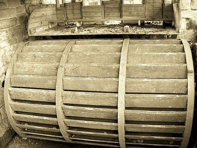
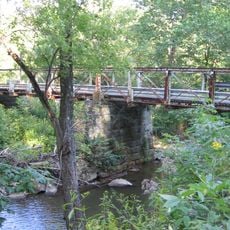
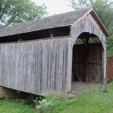
Gaston's Mill-Lock No. 36, Sandy and Beaver Canal District, Historic mill and lock in Clarkson, United States.

Gaston's Mill and Lock No. 36 sit within Beaver Creek State Park as a water-powered grist mill paired with a restored canal lock from the 1800s. The facility displays the machinery for grain processing and the lock mechanism that managed water levels for boat passage.

Construction of the Sandy and Beaver Canal started in 1834, with this lock as one of 90 that managed elevation changes across the waterway. The canal system enabled cargo transport between communities across varying terrain.

The mill served as a gathering point where farmers brought their grain and exchanged news about harvests and local events. Visitors can observe how water power connected the community through a shared need for grain processing.

Visits are best during months with mild weather when access to the buildings and lock mechanisms is unobstructed. The grounds require comfortable footwear and careful attention near water features and machinery.

The 1988 restoration involved workers in period dress using historical tools to rebuild the lock gates with their distinctive cantilevered wood-beam design. This hands-on approach revealed how labor-intensive the original construction must have been.

Location: Ohio

GPS coordinates: 40.72750,-80.61280

Latest update: December 14, 2025 18:09

Photos
Around this place
Beginning Point of the U.S. Public Land Survey
United States of America

Beginning Point of the U.S. Public Land Survey

12.3 km
Beaver Creek State Park
United States of America

Beaver Creek State Park

71 m
Jennings Randolph Bridge
United States of America

Jennings Randolph Bridge

12.8 km
Newell Toll Bridge
United States of America

Newell Toll Bridge

12.1 km
Richard L. Cawood Residence
United States of America

Richard L. Cawood Residence

9.9 km
Museum of Ceramics
United States of America

Museum of Ceramics

12.5 km
Carnegie Public Library
United States of America

Carnegie Public Library

12.6 km
Watts Mill Bridge
United States of America

Watts Mill Bridge

12.2 km
Cassius Clark Thompson House
United States of America

Cassius Clark Thompson House

12.8 km
Diamond Historic District
United States of America

Diamond Historic District

12.5 km
Ikirt House
United States of America

Ikirt House

12.2 km
Church Hill Road Covered Bridge
United States of America

Church Hill Road Covered Bridge

11.5 km
Salem Downtown Historic District
United States of America

Salem Downtown Historic District

9.9 km
Mary A. Patterson Memorial
United States of America

Mary A. Patterson Memorial

12.6 km
Potters National Bank
United States of America

Potters National Bank

12.7 km
William E. Wells House
United States of America

William E. Wells House

12.6 km
YMCA
United States of America

YMCA

12.5 km
Potters Savings and Loan
United States of America

Potters Savings and Loan

12.4 km
East Fifth Street Historic District
United States of America

East Fifth Street Historic District

12.5 km
Elks Club
United States of America

Elks Club

12.3 km
City Hall
United States of America

City Hall

12.3 km
Godwin-Knowles House
United States of America

Godwin-Knowles House

12.6 km
Homer Laughlin House
United States of America

Homer Laughlin House

12.6 km
Hiram Bell Farmstead
United States of America

Hiram Bell Farmstead

11.2 km
Nicholas Eckis House
United States of America

Nicholas Eckis House

10.8 km
Chester Bridge
United States of America

Chester Bridge

13.1 km
Odd Fellows Temple
United States of America

Odd Fellows Temple

12.2 km
Thomas J. Malone Bridge
United States of America

Thomas J. Malone Bridge

64 m
Show the full map
Reviews

Visited this place? Tap the stars to rate it and share your experience / photos with the community! Try now! You can cancel it anytime.

« Gaston's Mill-Lock No. 36, Sandy and Beaver Canal District - Historic mill and lock in Clarkson, United States » is provided by Around Us (aroundus.com). Images and texts are derived from Wikimedia project under a Creative Commons license. You are allowed to copy, distribute, and modify copies of this page, under the conditions set by the license, as long as this note is clearly visible.

Discover hidden gems everywhere you go!

From secret cafés to breathtaking viewpoints, skip the crowded tourist spots and find places that match your style. Our app makes it easy with voice search, smart filtering, route optimization, and insider tips from travelers worldwide. Download now for the complete mobile experience.

Around Us App Screenshot

A unique approach to discovering new places

Le Figaro

All the places worth exploring

France Info

A tailor-made excursion in just a few clicks

20 Minutes