Enable Location

We need your location to show you interesting places around you

Discover nearby places

Find interesting locations and hidden gems around you

Precise directions

Get accurate directions and distances to places

Your location is never shared with other users. It's only used when you tap the location button.

Log in to your account

Start exploring — it's free

Trusted by 62,535 travelers worldwide

Continue with Google
Continue with Apple
or

We will send you a code to connect

By continuing, you accept our Terms and Conditions and our Privacy Policy

Check your inbox

We've sent a pincode in your inbox. Please enter the code below.

California Hill State Forest

California Hill State Forest, State forest in New York, United States

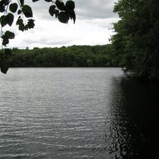
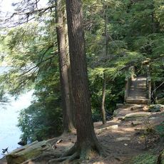
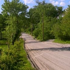
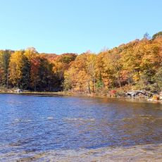
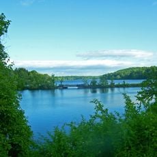
California Hill State Forest is a protected area in New York covering nearly 1000 acres of mixed forest, open spaces, and the 94-acre Waywayanda Lake. The landscape features gentle terrain, unmarked natural trails that wind through woods, and sections along the shoreline suitable for water activities.

The forest was historically used for logging and farming before being protected as a natural area to preserve its environment. Today it is managed by the New York State Department of Environmental Conservation, which maintains it for recreation and wildlife conservation.

The forest takes its name from a nearby hill and serves as a refuge where visitors come to slow down and observe nature firsthand. People use the trails and open spaces to connect with wildlife and find moments of quiet away from town.

The forest is open year-round and free to enter, making it an affordable option for outdoor activities. Visitors should bring their own water and supplies since facilities are minimal, and visiting during good weather allows you to enjoy the trails and lake activities more fully.

Waywayanda Lake within the forest draws canoeists and kayakers who launch from a small dock for calm water exploration. The lake supports fishing for bass, perch, and pike, making water access a memorable part of the visit that many overlook when planning their day.

The community of curious travelers

AroundUs brings together thousands of curated places, local tips, and hidden gems, enriched daily by 60,000 contributors worldwide.

Start exploring
Location
GPS coordinates
41.43833,-73.77306
Latest update
February 9, 2026 07:40
Around this place
Wonder Lake State Park
United States of America

Wonder Lake State Park

12.1 km
Massaro House
United States of America

Massaro House

6.8 km
Chuang Yen Monastery
United States of America

Chuang Yen Monastery

5.5 km
Clarence Fahnestock State Park
United States of America

Clarence Fahnestock State Park

7.2 km
Elephant Hotel
United States of America

Elephant Hotel

14.3 km
Boscobel
United States of America

Boscobel

14.2 km
Old Albany Post Road
United States of America

Old Albany Post Road

12.5 km
Van Wyck Homestead
United States of America

Van Wyck Homestead

13.5 km
Brewster High School
United States of America

Brewster High School

14.2 km
West Branch Reservoir
United States of America

West Branch Reservoir

6.3 km
Gerard Crane House
United States of America

Gerard Crane House

13.8 km
New Kursk-Root Icon Hermitage
United States of America

New Kursk-Root Icon Hermitage

6.5 km
Peekskill Downtown Historic District
United States of America

Peekskill Downtown Historic District

12.4 km
Reed Memorial Library
United States of America

Reed Memorial Library

8.1 km
Tompkins Corners United Methodist Church
United States of America

Tompkins Corners United Methodist Church

4.9 km
Walter Brewster House
United States of America

Walter Brewster House

14 km
Putnam County Courthouse
United States of America

Putnam County Courthouse

8 km
Indian Brook Road Historic District
United States of America

Indian Brook Road Historic District

12.3 km
Somers Hamlet Historic District
United States of America

Somers Hamlet Historic District

14.2 km
Old Southeast Town Hall
United States of America

Old Southeast Town Hall

14 km
Montrest
United States of America

Montrest

13.5 km
De Rham Farm
United States of America

De Rham Farm

14.1 km
First National Bank of Brewster
United States of America

First National Bank of Brewster

13.7 km
Hustis House
United States of America

Hustis House

14.2 km
Canopus Beach
United States of America

Canopus Beach

5.7 km
Middle Branch Reservoir
United States of America

Middle Branch Reservoir

11.7 km
Normandy Grange
United States of America

Normandy Grange

14.3 km
Mahopac Public Library
United States of America

Mahopac Public Library

8.1 km
Show the full map
« California Hill State Forest - State forest in New York, United States » is provided by Around Us (aroundus.com). Images and texts are derived from Wikimedia project under a Creative Commons license. You are allowed to copy, distribute, and modify copies of this page, under the conditions set by the license, as long as this note is clearly visible.

Discover hidden gems everywhere you go!

From secret cafés to breathtaking viewpoints, skip the crowded tourist spots and find places that match your style. Our app makes it easy with voice search, smart filtering, route optimization, and insider tips from travelers worldwide. Download now for the complete mobile experience.

Around Us App Screenshot

A unique approach to discovering new places

Le Figaro

All the places worth exploring

France Info

A tailor-made excursion in just a few clicks

20 Minutes

Around Us
Travel Guide & Maps
Download

Send to your phone

QR Code
1

Open the camera app on your mobile.

2

Point at the QR code with your camera. A notification will appear.

3

Tap the notification to open the link.