Chest opened
+${chestReward.xp} XP
Explorer
NOUVEAU ×${chestReward.collectible.quantity}
tapez pour fermer
Chest locked

Open chests in the app

Around Us is built for your phone — chests unlock when you walk, explore and capture nearby places.

Enable Location

We need your location to show you interesting places around you

Discover nearby places

Find interesting locations and hidden gems around you

Precise directions

Get accurate directions and distances to places

Your location is never shared with other users. It's only used when you tap the location button.

Conowingo Dam

Log in to your account

Start exploring — it's free

Trusted by 72,881 travelers worldwide

Continue with Google
Continue with Apple
or

We will send you a code to connect

By continuing, you accept our Terms and Conditions and our Privacy Policy

Check your inbox

We've sent a pincode in your inbox. Please enter the code below.

Discussion Reviews 1 Photos
35.1k Popularity

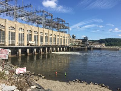
Conowingo Dam, Hydroelectric dam on Susquehanna River, Maryland.

Conowingo Dam is a hydroelectric structure that spans the Susquehanna River in Maryland, controlling water flow and generating electricity. The facility contains multiple spillway gates and turbines that work together to manage the river's power.

The structure was completed in the late 1920s by the Philadelphia Electric Company, marking a major shift in the region's power generation. Its completion represented an important step in harnessing water flow for electricity across a broader area.

The dam created a 9000-acre reservoir that transformed the local landscape and established new recreational opportunities for Maryland residents.

Visitors can observe the dam from several public viewpoints and watch water moving through the gates throughout the day. Check which areas are open to public viewing before you arrive, as some sections may have restricted access.

The facility has fish lifts that allow thousands of American shad to migrate upstream each year. This system helps maintain a critical part of the river's natural lifecycle and species balance.

The community of curious travelers

AroundUs brings together thousands of curated places, local tips, and hidden gems, enriched daily by 60,000 contributors worldwide.

Start exploring
Location
Inception
1926
Length
1,417 m
GPS coordinates
39.66000,-76.17390
Latest update
December 19, 2025 22:16
Around this place
Millard E. Tydings Memorial Bridge
United States of America

Millard E. Tydings Memorial Bridge

10.6 km
Tome School
United States of America

Tome School

8.6 km
West Nottingham Academy
United States of America

West Nottingham Academy

8.1 km
Susquehanna State Park
United States of America

Susquehanna State Park

6 km
Sion Hill
United States of America

Sion Hill

11.7 km
Conowingo Bridge
United States of America

Conowingo Bridge

3.4 km
Port Deposit Bridge
United States of America

Port Deposit Bridge

6.1 km
Chestnut Ridge
United States of America

Chestnut Ridge

11.2 km
Wildfell
United States of America

Wildfell

4 km
Colora Meetinghouse
United States of America

Colora Meetinghouse

6.7 km
Deer Creek Friends Meetinghouse
United States of America

Deer Creek Friends Meetinghouse

3.1 km
Darlington Historic District
United States of America

Darlington Historic District

3.2 km
West Nottingham Meetinghouse
United States of America

West Nottingham Meetinghouse

8.6 km
Berkley School
United States of America

Berkley School

2.7 km
Rock Run United Methodist Church
United States of America

Rock Run United Methodist Church

7 km
Priest Neal's Mass House and Mill Site
United States of America

Priest Neal's Mass House and Mill Site

10 km
Berkley Crossroads Historic District
United States of America

Berkley Crossroads Historic District

2.7 km
United States of America

Rigbie House

2.5 km
Finney Houses Historic District
United States of America

Finney Houses Historic District

11.3 km
Gray Gables
United States of America

Gray Gables

4.1 km
Silver Houses Historic District
United States of America

Silver Houses Historic District

6.3 km
Paw Paw Building
United States of America

Paw Paw Building

7.5 km
Thomas Richards House
United States of America

Thomas Richards House

6.5 km
Nathan and Susannah Harris House
United States of America

Nathan and Susannah Harris House

8.9 km
Edward W. Haviland House
United States of America

Edward W. Haviland House

8.6 km
Winsted
United States of America

Winsted

11.2 km
Lower Deer Creek Valley Historic District
United States of America

Lower Deer Creek Valley Historic District

7.5 km
Octorara Farm
United States of America

Octorara Farm

2.4 km
Show the full map
Reviews
Share your experience

No review yet

Discussions
Start a discussion...

No discussion yet

« Conowingo Dam - Hydroelectric dam on Susquehanna River, Maryland » is provided by Around Us (aroundus.com). Images and texts are derived from Wikimedia project under a Creative Commons license. You are allowed to copy, distribute, and modify copies of this page, under the conditions set by the license, as long as this note is clearly visible.

Discover hidden gems everywhere you go!

From secret cafés to breathtaking viewpoints, skip the crowded tourist spots and find places that match your style. Our app makes it easy with voice search, smart filtering, route optimization, and insider tips from travelers worldwide. Download now for the complete mobile experience.

Around Us App Screenshot

A unique approach to discovering new places

Le Figaro

All the places worth exploring

France Info

A tailor-made excursion in just a few clicks

20 Minutes

Around Us
Travel Guide & Maps
Download

Send to your phone

QR Code
1

Open the camera app on your mobile.

2

Point at the QR code with your camera. A notification will appear.

3

Tap the notification to open the link.