Enable Location

We need your location to show you interesting places around you

Discover nearby places

Find interesting locations and hidden gems around you

Precise directions

Get accurate directions and distances to places

Your location is never shared with other users. It's only used when you tap the location button.

El Dorado Lake

Log in to your account

Start exploring — it's free

Trusted by 65,438 travelers worldwide

Continue with Google
Continue with Apple
or

We will send you a code to connect

By continuing, you accept our Terms and Conditions and our Privacy Policy

Check your inbox

We've sent a pincode in your inbox. Please enter the code below.

El Dorado Lake
Discussion Reviews 1 Photos
8.1k Popularity

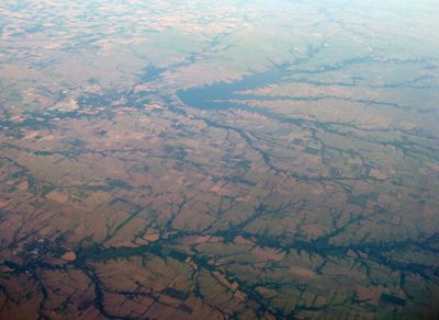
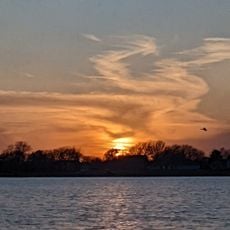
El Dorado Lake, reservoir in Kansas, United States of America

El Dorado Lake is a reservoir in Butler County, Kansas, that provides drinking water to nearby communities and also serves as a recreation area. The lake has several coves and a shoreline that alternates between open grassy areas and wooded sections, making it easy to find a spot away from the crowds.

The lake was formed in the 1980s when a dam was built on the Walnut River to secure a reliable water supply for the city of El Dorado. The construction flooded a stretch of river valley and created the open water surface that exists today.

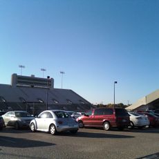
El Dorado Lake is a gathering place for people from across the region who come to fish, camp, or spend time outdoors. On weekends the shoreline fills with families, and the open areas around the water are used for picnics and walks.

The area around the lake covers a lot of ground, so it helps to decide in advance which section you want to explore, whether the marina, the campgrounds, or the more open shoreline. Spring and fall tend to offer the most comfortable conditions, since summer heat in Kansas can be intense.

Although the lake was built for water supply, a wildlife area runs along much of its shoreline, making it a stop for migratory birds passing through the region. Birdwatchers often head to the quieter coves to spot species that use the lake as a resting point on longer journeys.

The community of curious travelers

AroundUs brings together thousands of curated places, local tips, and hidden gems, enriched daily by 60,000 contributors worldwide.

Start exploring
Location
GPS coordinates
37.84722,-96.82306
Latest update
March 3, 2026 10:11
Around this place
Allen-Lambe House
United States of America

Allen-Lambe House

44.9 km
Cessna Stadium
United States of America

Cessna Stadium

43.9 km
Kansas Aviation Museum
United States of America

Kansas Aviation Museum

46.3 km
El Dorado State Park
United States of America

El Dorado State Park

4.8 km
Harvey House
United States of America

Harvey House

44.7 km
Ulrich Museum of Art
United States of America

Ulrich Museum of Art

44.1 km
Beaumont St. Louis and San Francisco Railroad Water Tank
United States of America

Beaumont St. Louis and San Francisco Railroad Water Tank

33.3 km
Augusta Historic Theatre
United States of America

Augusta Historic Theatre

24 km
Peabody Historical Library Museum
United States of America

Peabody Historical Library Museum

43.4 km
C. N. James Cabin
United States of America

C. N. James Cabin

24.5 km
Peabody Downtown Historic District
United States of America

Peabody Downtown Historic District

43.3 km
Peabody City Park
United States of America

Peabody City Park

43.6 km
W.H. Morgan House
United States of America

W.H. Morgan House

43.4 km
Cottonwood River Pratt Truss Bridge
United States of America

Cottonwood River Pratt Truss Bridge

46 km
Fairmount Congregational Church
United States of America

Fairmount Congregational Church

44.2 km
Butler County Courthouse
United States of America

Butler County Courthouse

4.2 km
Crocker Ranch
United States of America

Crocker Ranch

43.5 km
Peabody Township Library
United States of America

Peabody Township Library

43.4 km
El Dorado Carnegie Library
United States of America

El Dorado Carnegie Library

4.3 km
Burns Union School
United States of America

Burns Union School

27.5 km
Eureka Carnegie Library
United States of America

Eureka Carnegie Library

46.6 km
Douglass Township Community Building
United States of America

Douglass Township Community Building

40.6 km
Administration Building
United States of America

Administration Building

46.3 km
Loomis–Parry Residence
United States of America

Loomis–Parry Residence

22.9 km
Frank Lloyd Wright's Allen House
United States of America

Frank Lloyd Wright's Allen House

44.9 km
Teter Rock
United States of America

Teter Rock

40.5 km
Little Walnut River Pratt Truss Bridge
United States of America

Little Walnut River Pratt Truss Bridge

29.3 km
Splash Pad
United States of America

Splash Pad

20.4 km
Show the full map
Reviews
Share your experience

No review yet

Discussions
Start a discussion...

No discussion yet

« El Dorado Lake - reservoir in Kansas, United States of America » is provided by Around Us (aroundus.com). Images and texts are derived from Wikimedia project under a Creative Commons license. You are allowed to copy, distribute, and modify copies of this page, under the conditions set by the license, as long as this note is clearly visible.

Discover hidden gems everywhere you go!

From secret cafés to breathtaking viewpoints, skip the crowded tourist spots and find places that match your style. Our app makes it easy with voice search, smart filtering, route optimization, and insider tips from travelers worldwide. Download now for the complete mobile experience.

Around Us App Screenshot

A unique approach to discovering new places

Le Figaro

All the places worth exploring

France Info

A tailor-made excursion in just a few clicks

20 Minutes

Around Us
Travel Guide & Maps
Download

Send to your phone

QR Code
1

Open the camera app on your mobile.

2

Point at the QR code with your camera. A notification will appear.

3

Tap the notification to open the link.