Chest opened
+${chestReward.xp} XP
Explorer
NOUVEAU ×${chestReward.collectible.quantity}
tapez pour fermer
Chest locked

Open chests in the app

Around Us is built for your phone — chests unlock when you walk, explore and capture nearby places.

Enable Location

We need your location to show you interesting places around you

Discover nearby places

Find interesting locations and hidden gems around you

Precise directions

Get accurate directions and distances to places

Your location is never shared with other users. It's only used when you tap the location button.

Log in to your account

Start exploring — it's free

Trusted by 72,986 travelers worldwide

Continue with Google
Continue with Apple
or

We will send you a code to connect

By continuing, you accept our Terms and Conditions and our Privacy Policy

Check your inbox

We've sent a pincode in your inbox. Please enter the code below.

Fort Belmont
Discussion Reviews Photo
1.4k Popularity

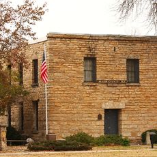
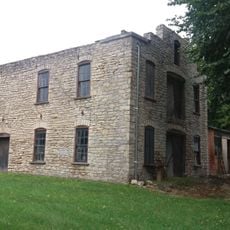
Fort Belmont, Military fort in Woodson County, Kansas, United States.

Fort Belmont was a fortified settlement featuring three officer quarters, a rectangular earthwork structure, and a parade ground extending to the east. The central redoubt had multiple wooden layers built atop earthen embankments with a house constructed at its center as the focal point.

The fort was established in 1860 to shield settlers amid conflict between pro-slavery and free-state factions during the Kansas-Missouri Border War. It played a key role in controlling the region during this turbulent period of expansion and political division.

The site functioned as a federal hub for managing relations between Osage and Creek nations and the incoming settler population. Visitors can still sense how this location served as a meeting point between two different communities.

The site is located about two miles west of Buffalo and can be accessed via Kanza Road and 70th Road. The remains are visible from the road and can be explored on foot, particularly in drier conditions.

What set this installation apart was how its wooden structures and earthen embankments worked together to create a multilayered defensive barrier. This building method was uncommon for frontier settlements and reflected unusual engineering innovation for its era.

The community of curious travelers

AroundUs brings together thousands of curated places, local tips, and hidden gems, enriched daily by 60,000 contributors worldwide.

Start exploring
Location
GPS coordinates
37.83140,-95.78800
Latest update
December 14, 2025 17:02
Around this place
Big Hill Lake
United States of America

Big Hill Lake

67.3 km
Elk City State Park
United States of America

Elk City State Park

64.1 km
Cross Timbers State Park
United States of America

Cross Timbers State Park

15 km
Allen County Jail
United States of America

Allen County Jail

35.4 km
Norman No. 1 Oil Well
United States of America

Norman No. 1 Oil Well

47.5 km
Greenwood Hotel
United States of America

Greenwood Hotel

44.4 km
Northrup House
United States of America

Northrup House

35.6 km
Booth Theater
United States of America

Booth Theater

67.9 km
Gold Dust Hotel
United States of America

Gold Dust Hotel

33.3 km
Robertson House
United States of America

Robertson House

43.6 km
Brown Hotel
United States of America

Brown Hotel

47 km
Neosho River Bridge
United States of America

Neosho River Bridge

55 km
Burlington Carnegie Free Library
United States of America

Burlington Carnegie Free Library

40.8 km
Burlington Opry
United States of America

Burlington Opry

40.7 km
Woodson County Courthouse
United States of America

Woodson County Courthouse

7.4 km
Elk Falls Pratt Truss Bridge
United States of America

Elk Falls Pratt Truss Bridge

61.7 km
Eureka Carnegie Library
United States of America

Eureka Carnegie Library

44.5 km
City Square Park Bandstand
United States of America

City Square Park Bandstand

31 km
Lander's Wagon and Carriage Shop
United States of America

Lander's Wagon and Carriage Shop

30.5 km
State Street Bridge
United States of America

State Street Bridge

56.2 km
Yates Center Courthouse Square Historic District
United States of America

Yates Center Courthouse Square Historic District

7.9 km
Yates Center Carnegie Library
United States of America

Yates Center Carnegie Library

7.6 km
Brush Creek Bridge
United States of America

Brush Creek Bridge

19.6 km
Stockbrands and Kemmerer Department Store
United States of America

Stockbrands and Kemmerer Department Store

7.4 km
Murray High School
United States of America

Murray High School

33.6 km
Teter Rock
United States of America

Teter Rock

60 km
Martin and Osa Johnson Safari Museum
United States of America

Martin and Osa Johnson Safari Museum

33.8 km
Independence Historical Museum & Art Center
United States of America

Independence Historical Museum & Art Center

68 km
Show the full map
Reviews
Share your experience

No review yet

Discussions
Start a discussion...

No discussion yet

« Fort Belmont - Military fort in Woodson County, Kansas, United States » is provided by Around Us (aroundus.com). Images and texts are derived from Wikimedia project under a Creative Commons license. You are allowed to copy, distribute, and modify copies of this page, under the conditions set by the license, as long as this note is clearly visible.

Discover hidden gems everywhere you go!

From secret cafés to breathtaking viewpoints, skip the crowded tourist spots and find places that match your style. Our app makes it easy with voice search, smart filtering, route optimization, and insider tips from travelers worldwide. Download now for the complete mobile experience.

Around Us App Screenshot

A unique approach to discovering new places

Le Figaro

All the places worth exploring

France Info

A tailor-made excursion in just a few clicks

20 Minutes

Around Us
Travel Guide & Maps
Download

Send to your phone

QR Code
1

Open the camera app on your mobile.

2

Point at the QR code with your camera. A notification will appear.

3

Tap the notification to open the link.