Chest opened
+${chestReward.xp} XP
Explorer
NOUVEAU ×${chestReward.collectible.quantity}
tapez pour fermer
Chest locked

Open chests in the app

Around Us is built for your phone — chests unlock when you walk, explore and capture nearby places.

Enable Location

We need your location to show you interesting places around you

Discover nearby places

Find interesting locations and hidden gems around you

Precise directions

Get accurate directions and distances to places

Your location is never shared with other users. It's only used when you tap the location button.

Fort Cumberland

Log in to your account

Start exploring — it's free

Trusted by 72,881 travelers worldwide

Continue with Google
Continue with Apple
or

We will send you a code to connect

By continuing, you accept our Terms and Conditions and our Privacy Policy

Check your inbox

We've sent a pincode in your inbox. Please enter the code below.

Discussion Reviews 1 Photos
9k Popularity

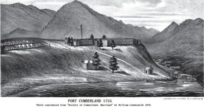
Fort Cumberland, 18th century frontier fort in Cumberland, Maryland, United States.

Fort Cumberland was a military installation at the confluence of Wills Creek and the Potomac River, featuring wooden fortifications arranged in a rectangular layout. The outpost was strategically placed to monitor and control commerce and troop movement across this frontier region.

The fort was established in 1754 as Fort Mount Pleasant and served as the westernmost British outpost in North America during the French and Indian War. It gradually lost military importance as territorial boundaries shifted eastward and was eventually abandoned.

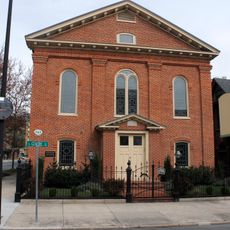
The site served as a vital supply hub and prisoner detention center during the Revolutionary War, holding troops from both sides. Local residents today connect with this military past through the preserved remains that lie beneath a nearby church.

The original site is marked today by marble markers near Emmanuel Episcopal Church in downtown Cumberland. No structures remain above ground, but underground passages beneath the church can be partially explored.

Tunnels beneath the adjacent church represent some of the most intact remains and reveal 18th-century engineering techniques. Historical drawings and plans are housed in overseas museum collections, preserving details of features that have vanished from the ground.

The community of curious travelers

AroundUs brings together thousands of curated places, local tips, and hidden gems, enriched daily by 60,000 contributors worldwide.

Start exploring
Location
GPS coordinates
39.65110,-78.76530
Latest update
December 8, 2025 08:21
Around this place
Canal Place
United States of America

Canal Place

250 m
Headquarters of George Washington
United States of America

Headquarters of George Washington

192 m
B'er Chayim Temple
United States of America

B'er Chayim Temple

407 m
Downtown Cumberland Historic District
United States of America

Downtown Cumberland Historic District

362 m
Wills Mountain State Park
United States of America

Wills Mountain State Park

2.9 km
Klots Throwing Company Mill
United States of America

Klots Throwing Company Mill

998 m
Washington Street Historic District
United States of America

Washington Street Historic District

473 m
Allegany County Courthouse
United States of America

Allegany County Courthouse

141 m
Town Clock Church
United States of America

Town Clock Church

762 m
Cumberland YMCA
United States of America

Cumberland YMCA

605 m
Public Safety Building
United States of America

Public Safety Building

247 m
African Methodist Episcopal Church
United States of America

African Methodist Episcopal Church

727 m
Bell Tower Building
United States of America

Bell Tower Building

259 m
Folck's Mill
United States of America

Folck's Mill

4.4 km
Greene Street Historic District
United States of America

Greene Street Historic District

592 m
City Hall
United States of America

City Hall

306 m
First Baptist Church
United States of America

First Baptist Church

621 m
Francis Haley House
United States of America

Francis Haley House

986 m
Rolling Mill Historic District
United States of America

Rolling Mill Historic District

987 m
George Truog House
United States of America

George Truog House

677 m
Thomas Koon House
United States of America

Thomas Koon House

645 m
Decatur Heights Historic District
United States of America

Decatur Heights Historic District

1.1 km
16 Altamont Terrace
United States of America

16 Altamont Terrace

768 m
Wright Butler House
United States of America

Wright Butler House

668 m
200-208 Decatur Street
United States of America

200-208 Decatur Street

713 m
Chapel Hill Historic District
United States of America

Chapel Hill Historic District

1.5 km
United States of America

Washington Street Library

105 m
Blue Bridge
United States of America

Blue Bridge

282 m
Show the full map
Reviews
Share your experience

No review yet

Discussions
Start a discussion...

No discussion yet

« Fort Cumberland - 18th century frontier fort in Cumberland, Maryland, United States » is provided by Around Us (aroundus.com). Images and texts are derived from Wikimedia project under a Creative Commons license. You are allowed to copy, distribute, and modify copies of this page, under the conditions set by the license, as long as this note is clearly visible.

Discover hidden gems everywhere you go!

From secret cafés to breathtaking viewpoints, skip the crowded tourist spots and find places that match your style. Our app makes it easy with voice search, smart filtering, route optimization, and insider tips from travelers worldwide. Download now for the complete mobile experience.

Around Us App Screenshot

A unique approach to discovering new places

Le Figaro

All the places worth exploring

France Info

A tailor-made excursion in just a few clicks

20 Minutes

Around Us
Travel Guide & Maps
Download

Send to your phone

QR Code
1

Open the camera app on your mobile.

2

Point at the QR code with your camera. A notification will appear.

3

Tap the notification to open the link.