Enable Location

We need your location to show you interesting places around you

Discover nearby places

Find interesting locations and hidden gems around you

Precise directions

Get accurate directions and distances to places

Your location is never shared with other users. It's only used when you tap the location button.

Fort Rice

Log in to your account

Start exploring — it's free

Trusted by 62,857 travelers worldwide

Continue with Google
Continue with Apple
or

We will send you a code to connect

By continuing, you accept our Terms and Conditions and our Privacy Policy

Check your inbox

We've sent a pincode in your inbox. Please enter the code below.

Fort Rice

Fort Rice, Military fort site near Mandan, United States.
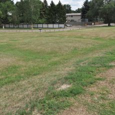
Fort Rice was a military installation along the Missouri River featuring wooden palisades, watchtowers, barracks, a hospital, and officers' quarters. The layout spread across several hundred acres and was positioned to control river crossings and main transportation routes.

General Alfred Sully established Fort Rice in 1864 as a military outpost to protect transportation corridors across the Northern Plains. Shortly after its founding, the site became central to mounting conflicts with the Lakota and served as a base for military operations throughout the region.

The site marks a significant crossing point where military personnel and Lakota people came into direct contact, shaping frontier relations in this region.

Visitors can trace building foundations and ground features marked by historic preservation indicators at the site. The open terrain allows for easy walking, though on-site interpretive resources may be limited.

The first winter at this military post proved deadly for the garrison, with casualties from both disease and conflicts with Lakota warriors. This harsh beginning became a defining moment in the fort's short history.

The community of curious travelers

AroundUs brings together thousands of curated places, local tips, and hidden gems, enriched daily by 60,000 contributors worldwide.

Start exploring
Location
GPS coordinates
46.51280,-100.58400
Latest update
December 11, 2025 18:10
Around this place
North Dakota State Capitol
United States of America

North Dakota State Capitol

37.5 km
Fort Abraham Lincoln
United States of America

Fort Abraham Lincoln

34.6 km
North Dakota Governor's Residence
United States of America

North Dakota Governor's Residence

37.2 km
United States of America

North Dakota Heritage Center

37.3 km
Bismarck North Dakota Temple
United States of America

Bismarck North Dakota Temple

40.3 km
Cathedral of the Holy Spirit
United States of America

Cathedral of the Holy Spirit

36.8 km
Huff Archeological Site
United States of America

Huff Archeological Site

12.6 km
United States of America

Liberty Memorial Building

37.3 km
Liberty Memorial Bridge
United States of America

Liberty Memorial Bridge

38.9 km
Former North Dakota Executive Mansion
United States of America

Former North Dakota Executive Mansion

36.6 km
Camp Hancock State Historic Site
United States of America

Camp Hancock State Historic Site

36.2 km
Annunciation Monastery
United States of America

Annunciation Monastery

26.4 km
Our Lady of the Annunciation Chapel at Annunciation Priory
United States of America

Our Lady of the Annunciation Chapel at Annunciation Priory

26.6 km
Bismarck Air Museum
United States of America

Bismarck Air Museum

32.8 km
E. G. Patterson Building
United States of America

E. G. Patterson Building

36 km
Emmons County Courthouse
United States of America

Emmons County Courthouse

38.2 km
Bismarck Cathedral Area Historic District
United States of America

Bismarck Cathedral Area Historic District

36.9 km
Chief Looking's Village site
United States of America

Chief Looking's Village site

40 km
Burleigh County Courthouse
United States of America

Burleigh County Courthouse

36.2 km
United States Post Office and Courthouse
United States of America

United States Post Office and Courthouse

36.2 km
Bismarck Civic Auditorium
United States of America

Bismarck Civic Auditorium

36 km
Missouri River High Bridge
United States of America

Missouri River High Bridge

38.7 km
Fred and Gladys Grady House
United States of America

Fred and Gladys Grady House

37 km
Dr. Albert M. and Evelyn M. Brandt House
United States of America

Dr. Albert M. and Evelyn M. Brandt House

35.5 km
Towne–Williams House
United States of America

Towne–Williams House

36.6 km
North Dakota Heritage Center & State Museum
United States of America

North Dakota Heritage Center & State Museum

37.2 km
Former Governors' Mansion State Historic Site
United States of America

Former Governors' Mansion State Historic Site

36.6 km
Camp Hancock State Historic Site
United States of America

Camp Hancock State Historic Site

36.2 km
Show the full map
« Fort Rice - Military fort site near Mandan, United States » is provided by Around Us (aroundus.com). Images and texts are derived from Wikimedia project under a Creative Commons license. You are allowed to copy, distribute, and modify copies of this page, under the conditions set by the license, as long as this note is clearly visible.

Discover hidden gems everywhere you go!

From secret cafés to breathtaking viewpoints, skip the crowded tourist spots and find places that match your style. Our app makes it easy with voice search, smart filtering, route optimization, and insider tips from travelers worldwide. Download now for the complete mobile experience.

Around Us App Screenshot

A unique approach to discovering new places

Le Figaro

All the places worth exploring

France Info

A tailor-made excursion in just a few clicks

20 Minutes

Around Us
Travel Guide & Maps
Download

Send to your phone

QR Code
1

Open the camera app on your mobile.

2

Point at the QR code with your camera. A notification will appear.

3

Tap the notification to open the link.