Chest opened
+${chestReward.xp} XP
Explorer
NOUVEAU ×${chestReward.collectible.quantity}
tapez pour fermer
Chest locked

Open chests in the app

Around Us is built for your phone — chests unlock when you walk, explore and capture nearby places.

Enable Location

We need your location to show you interesting places around you

Discover nearby places

Find interesting locations and hidden gems around you

Precise directions

Get accurate directions and distances to places

Your location is never shared with other users. It's only used when you tap the location button.

Log in to your account

Start exploring — it's free

Trusted by 72,883 travelers worldwide

Continue with Google
Continue with Apple
or

We will send you a code to connect

By continuing, you accept our Terms and Conditions and our Privacy Policy

Check your inbox

We've sent a pincode in your inbox. Please enter the code below.

Freedom Rock
Discussion Reviews Photo
3.9k Popularity

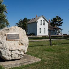
Freedom Rock, Veteran memorial rock in Menlo, Iowa, United States

Freedom Rock is a large boulder along Iowa Highway 25 near Menlo, Iowa, whose entire surface is repainted by hand each year with portraits of military veterans and patriotic designs. The rock stands in the open next to the road and is visible from all sides.

The artist Ray Sorensen transformed the boulder into a veterans memorial in 1999 after being inspired by the film Saving Private Ryan. Since then, the painting has been renewed every year, making each season a completely new work.

The rock displays new portraits of veterans each year, so every visit offers a different image. Visitors often stop to study the painted faces and share their own memories of people who served.

The rock sits right beside the road and is easy to reach without any hiking or long walk. A short stop during a drive through Iowa is enough to see the current paintings up close.

Ray Sorensen mixes the ashes of deceased veterans into the paint when creating each year's new design. This means the remains of fallen service members are literally worked into the surface of the rock.

The community of curious travelers

AroundUs brings together thousands of curated places, local tips, and hidden gems, enriched daily by 60,000 contributors worldwide.

Start exploring
Location
GPS coordinates
41.47490,-94.45220
Latest update
March 3, 2026 14:05
Around this place
Roseman Covered Bridge
United States of America

Roseman Covered Bridge

32.4 km
Hogback Covered Bridge
United States of America

Hogback Covered Bridge

35.2 km
Springbrook State Park
United States of America

Springbrook State Park

33.6 km
All Saints Catholic Church
United States of America

All Saints Catholic Church

11.8 km
Iowa Aviation Museum
United States of America

Iowa Aviation Museum

16.6 km
Dallas County Courthouse
United States of America

Dallas County Courthouse

39.6 km
Madison County Courthouse
United States of America

Madison County Courthouse

39.6 km
Adair County Courthouse
United States of America

Adair County Courthouse

19 km
Masonic Temple Building
United States of America

Masonic Temple Building

11.6 km
Sexton Hotel
United States of America

Sexton Hotel

11.8 km
Henry C. Wallace House
United States of America

Henry C. Wallace House

39.4 km
Guthrie County Courthouse
United States of America

Guthrie County Courthouse

23 km
Hotel Greenfield
United States of America

Hotel Greenfield

18.9 km
Adair Viaduct
United States of America

Adair Viaduct

16.1 km
Dexter Community House
United States of America

Dexter Community House

19.2 km
North River Stone Schoolhouse
United States of America

North River Stone Schoolhouse

35.1 km
Guiberson House
United States of America

Guiberson House

39.5 km
W.J. and Nettie J. Cornell House
United States of America

W.J. and Nettie J. Cornell House

39.3 km
Winterset Courthouse Square Commercial Historic District
United States of America

Winterset Courthouse Square Commercial Historic District

39.8 km
Catalpa
United States of America

Catalpa

28.1 km
John D. Bush House
United States of America

John D. Bush House

37.7 km
Earlham Public School
United States of America

Earlham Public School

27.7 km
Adel Public Square Historic District
United States of America

Adel Public Square Historic District

39.5 km
Warren Opera House Block and Hetherington Block
United States of America

Warren Opera House Block and Hetherington Block

18.9 km
Former Audubon County Courthouse
United States of America

Former Audubon County Courthouse

37.5 km
Emily Hornback House
United States of America

Emily Hornback House

39.7 km
White, Munger and Company Store
United States of America

White, Munger and Company Store

39.7 km
Miller Richard and Mary Fisher Tidrick House
United States of America

Miller Richard and Mary Fisher Tidrick House

39.5 km
Show the full map
Reviews
Share your experience

No review yet

Discussions
Start a discussion...

No discussion yet

« Freedom Rock - Veteran memorial rock in Menlo, Iowa, United States » is provided by Around Us (aroundus.com). Images and texts are derived from Wikimedia project under a Creative Commons license. You are allowed to copy, distribute, and modify copies of this page, under the conditions set by the license, as long as this note is clearly visible.

Discover hidden gems everywhere you go!

From secret cafés to breathtaking viewpoints, skip the crowded tourist spots and find places that match your style. Our app makes it easy with voice search, smart filtering, route optimization, and insider tips from travelers worldwide. Download now for the complete mobile experience.

Around Us App Screenshot

A unique approach to discovering new places

Le Figaro

All the places worth exploring

France Info

A tailor-made excursion in just a few clicks

20 Minutes

Around Us
Travel Guide & Maps
Download

Send to your phone

QR Code
1

Open the camera app on your mobile.

2

Point at the QR code with your camera. A notification will appear.

3

Tap the notification to open the link.