·

Enable Location

We need your location to show you interesting places around you

Discover nearby places

Find interesting locations and hidden gems around you

Precise directions

Get accurate directions and distances to places

Your location is never shared with other users. It's only used when you tap the location button.

Log in to your account

Start exploring — it's free

Trusted by 62,738 travelers worldwide

Continue with Google
Continue with Apple
or

We will send you a code to connect

By continuing, you accept our Terms and Conditions and our Privacy Policy

Check your inbox

We've sent a pincode in your inbox. Please enter the code below.

Greenwood Reservoir

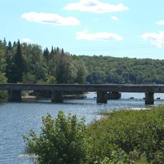
Greenwood Reservoir, body of water

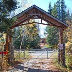
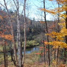
Greenwood Reservoir is a body of water in Ely Township, Michigan, surrounded by trees and open spaces that offer opportunities for walking and picnicking. The water has a calm surface framed by forest, with small islands dotted with pine trees and a soft ice blue color that shifts with the light.

The reservoir has served the community for many years as a place for water management and recreation, becoming a long-standing part of the local landscape. While specific origins remain undocumented, it has functioned as a recreational space and integral element of the local water system for generations.

The reservoir serves as a gathering place where local families have spent time for generations, enjoying simple outdoor activities and walks along the shore. The absence of heavy development has kept it a straightforward spot where people come to rest and reconnect with nature away from daily routines.

Visitors should bring their own supplies like water, snacks, and a picnic blanket, as the area has few facilities. The gently rolling terrain makes it easy for people of all ages to explore on foot, with trails leading closer to the water or deeper into the woods.

Patches of mushrooms grow in the woods near the water, though visitors are cautioned that some species can be poisonous and should not be touched or eaten. The changing seasons heighten this natural display as leaf colors shift while pine trees maintain their dark green needles as a constant backdrop.

The community of curious travelers

AroundUs brings together thousands of curated places, local tips, and hidden gems, enriched daily by 60,000 contributors worldwide.

Start exploring
Location
GPS coordinates
46.44280,-87.80220
Latest update
February 9, 2026 08:18
Around this place
National Ski Hall of Fame
United States of America

National Ski Hall of Fame

12.5 km
Cliffs Shaft Mine Museum
United States of America

Cliffs Shaft Mine Museum

11.1 km
Mather Inn
United States of America

Mather Inn

11.6 km
Trunk Line Bridge No. 1
United States of America

Trunk Line Bridge No. 1

18.1 km
Sam Cohodas Lodge
United States of America

Sam Cohodas Lodge

18 km
Vista Theater
United States of America

Vista Theater

6.9 km
Carp River Forge
United States of America

Carp River Forge

20.1 km
Sundberg Block
United States of America

Sundberg Block

15.8 km
Negaunee Fire Station
United States of America

Negaunee Fire Station

16.1 km
Ishpeming Municipal Building
United States of America

Ishpeming Municipal Building

11.5 km
Cleveland Mine Engine House Number 3
United States of America

Cleveland Mine Engine House Number 3

12.1 km
Ishpeming Main Street Historic District
United States of America

Ishpeming Main Street Historic District

11.5 km
Reine utsiktspunkt
Norway

Reine utsiktspunkt

4 km
Negaunee State Bank Building
United States of America

Negaunee State Bank Building

16 km
Ishpeming Carnegie Public Library
United States of America

Ishpeming Carnegie Public Library

11.5 km
United States of America

Morgan Falls

28.8 km
United States of America

Forestville Fireplace

29.5 km
United States of America

Lower Carp Falls

28.1 km
United States of America

Black River Falls

5.7 km
United States of America

Oak Hill Lookout

28.8 km
United States of America

Scenic viewpoint

15.3 km
United States of America

Marquette Township Overlook

29.8 km
United States of America

Top Of The World

29.9 km
United States of America

Cedar Lake Overlook

13 km
United States of America

Scenic viewpoint

12.7 km
United States of America

Republic Mine Observation Deck

14.5 km
United States of America

Two Lookouts

13.1 km
United States of America

Morgan Falls Overlook

28.8 km
Show the full map
« Greenwood Reservoir - body of water » is provided by Around Us (aroundus.com). Images and texts are derived from Wikimedia project under a Creative Commons license. You are allowed to copy, distribute, and modify copies of this page, under the conditions set by the license, as long as this note is clearly visible.

Discover hidden gems everywhere you go!

From secret cafés to breathtaking viewpoints, skip the crowded tourist spots and find places that match your style. Our app makes it easy with voice search, smart filtering, route optimization, and insider tips from travelers worldwide. Download now for the complete mobile experience.

Around Us App Screenshot

A unique approach to discovering new places

Le Figaro

All the places worth exploring

France Info

A tailor-made excursion in just a few clicks

20 Minutes

Around Us
Travel Guide & Maps
Download

Send to your phone

QR Code
1

Open the camera app on your mobile.

2

Point at the QR code with your camera. A notification will appear.

3

Tap the notification to open the link.