Reine utsiktspunkt

Log in to your account

AroundUs is a community-driven map of interesting places, built by curious explorers like you. It grows with every review, story, and photo you share.
Connect to save your favorite spots, contribute locations, and create personalized routes.
Continue with Google
Continue with Apple
Continue with X
Continue with Facebook
Continue with email
By continuing, you accept our Terms and Conditions and our Privacy Policy
Create an account
Add to collection
Map
Suggest a change
Share

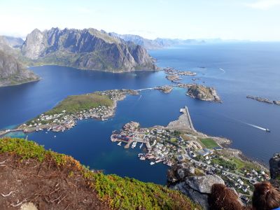
Reine utsiktspunkt, Observation point in Reine, Norway

This viewpoint sits high above Reine and reveals the full shape of the settlement, the fjord waters, and the granite mountains that surround everything. The location offers a view where you can see how the fishing cabins relate to the water and the steep rock walls that define this corner of Lofoten.

Reine developed as a fishing settlement centuries ago because the bay provided excellent conditions for catching cod and other fish. The path to this viewpoint was constructed relatively recently to allow visitors safe access without damaging the natural terrain.

The viewpoint reveals how locals live within their dramatic landscape: from here, you can see the red fishing cabins nestled below and understand why people built their homes in this remote valley. The view connects you to a way of life that has always depended on the water and the surrounding granite walls.

The climb requires physical effort and solid footwear since the steps are steep and exposed to weather on the mountainside. Plan to spend time on the walk up, and consider the conditions at the top which can be windy regardless of how it appears from below.

During the summer months, this spot offers a rare experience where daylight persists continuously, allowing you to watch the sun move across the horizon for hours without setting. The changing light angles create constantly shifting shadows across the water and mountains below.

Location: Reine

Address: Unnamed Road,8390, Reine, Norway

GPS coordinates: 46.45550,-87.85166

Latest update: December 9, 2025 20:28

Photos
Around this place
Superior Dome
United States of America

Superior Dome

37 km
Granot Loma
United States of America

Granot Loma

35.7 km
Marquette Branch Prison
United States of America

Marquette Branch Prison

36.5 km
National Ski Hall of Fame
United States of America

National Ski Hall of Fame

15.2 km
Holy Family Orphanage
United States of America

Holy Family Orphanage

35.6 km
Cliffs Shaft Mine Museum
United States of America

Cliffs Shaft Mine Museum

14.1 km
Peter White Public Library
United States of America

Peter White Public Library

36.5 km
Mather Inn
United States of America

Mather Inn

14.6 km
Trunk Line Bridge No. 1
United States of America

Trunk Line Bridge No. 1

14.2 km
Marquette County Courthouse
United States of America

Marquette County Courthouse

36.2 km
Palestra, The Marquette
United States of America

Palestra, The Marquette

36.8 km
United States of America

McCormick Wilderness

28 km
Sam Cohodas Lodge
United States of America

Sam Cohodas Lodge

14.1 km
Vista Theater
United States of America

Vista Theater

4.7 km
Marquette City Hall
United States of America

Marquette City Hall

36.3 km
Coaster II
United States of America

Coaster II

36.6 km
Savings Bank Building
United States of America

Savings Bank Building

36.5 km
Arch and Ridge Streets Historic District
United States of America

Arch and Ridge Streets Historic District

37.1 km
Carp River Forge
United States of America

Carp River Forge

23.1 km
Sundberg Block
United States of America

Sundberg Block

18.9 km
Longyear Building
United States of America

Longyear Building

36.6 km
Ishpeming Municipal Building
United States of America

Ishpeming Municipal Building

14.5 km
Cleveland Mine Engine House Number 3
United States of America

Cleveland Mine Engine House Number 3

15.3 km
Longyear Hall of Pedagogy
United States of America

Longyear Hall of Pedagogy

36.5 km
Ishpeming Main Street Historic District
United States of America

Ishpeming Main Street Historic District

14.5 km
Marquette Regional History Center
United States of America

Marquette Regional History Center

36.2 km
Negaunee State Bank Building
United States of America

Negaunee State Bank Building

19.1 km
Ishpeming Carnegie Public Library
United States of America

Ishpeming Carnegie Public Library

14.5 km
Show the full map
Reviews

Visited this place? Tap the stars to rate it and share your experience / photos with the community! Try now! You can cancel it anytime.

« Reine utsiktspunkt - Observation point in Reine, Norway » is provided by Around Us (aroundus.com). Images and texts are derived from Wikimedia project under a Creative Commons license. You are allowed to copy, distribute, and modify copies of this page, under the conditions set by the license, as long as this note is clearly visible.

Discover hidden gems everywhere you go!

From secret cafés to breathtaking viewpoints, skip the crowded tourist spots and find places that match your style. Our app makes it easy with voice search, smart filtering, route optimization, and insider tips from travelers worldwide. Download now for the complete mobile experience.

Around Us App Screenshot

A unique approach to discovering new places

Le Figaro

All the places worth exploring

France Info

A tailor-made excursion in just a few clicks

20 Minutes