Enable Location

We need your location to show you interesting places around you

Discover nearby places

Find interesting locations and hidden gems around you

Precise directions

Get accurate directions and distances to places

Your location is never shared with other users. It's only used when you tap the location button.

Halfway Rock Light

Log in to your account

Start exploring — it's free

Trusted by 63,006 travelers worldwide

Continue with Google
Continue with Apple
or

We will send you a code to connect

By continuing, you accept our Terms and Conditions and our Privacy Policy

Check your inbox

We've sent a pincode in your inbox. Please enter the code below.

Discussion Reviews 1 Photos
7.8k Popularity

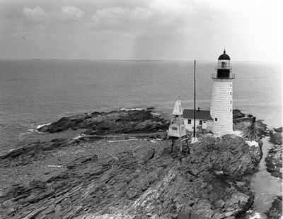
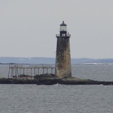
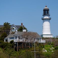
Halfway Rock Light, Lighthouse in Cumberland County, Maine, US.

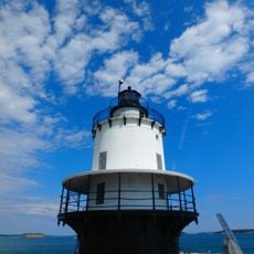
Halfway Rock Light is a lighthouse standing on a rocky ledge in Casco Bay, roughly two miles from Portland. The conical granite tower features white exterior walls with a black lantern room at the top, rising about 23 meters high.

The lighthouse was built in 1871 by the U.S. Army Corps of Engineers following a series of shipwrecks in these perilous waters. Its construction marked an effort to improve navigation safety along the Maine coast.

The name comes from its location midway between two capes, serving as a crucial reference point for mariners navigating these waters. This landmark became deeply connected to the region's seafaring community and their understanding of safe passage through the bay.

The lighthouse can only be reached by boat since it sits on an isolated rocky ledge far from shore. Visitors should be aware that tides and weather conditions may affect boat access to the site.

The original conical tower and attached boathouse have survived intact, while storms have swept away every other building from the rocky foundation. This survival speaks to the resilient construction needed to withstand the harsh conditions of this exposed location.

The community of curious travelers

AroundUs brings together thousands of curated places, local tips, and hidden gems, enriched daily by 60,000 contributors worldwide.

Start exploring
Inception
1871
Architects
United States Army Corps of Engineers
Height
23 m
GPS coordinates
43.65578,-70.03678
Latest update
December 8, 2025 20:00
Around this place
Portland Head Light
United States of America

Portland Head Light

14.2 km
Fort Gorges
United States of America

Fort Gorges

14.9 km
Battery Steele
United States of America

Battery Steele

11.6 km
Bailey Island Bridge
United States of America

Bailey Island Bridge

11.1 km
Fort Williams
United States of America

Fort Williams

14.5 km
Fort Preble
United States of America

Fort Preble

15.3 km
Ram Island Ledge Light
United States of America

Ram Island Ledge Light

12.4 km
Portland Breakwater Light
United States of America

Portland Breakwater Light

16 km
United States of America

Harbor Defenses of Portland

15.3 km
Fort McKinley, Maine
United States of America

Fort McKinley, Maine

13.2 km
Spring Point Ledge Light
United States of America

Spring Point Ledge Light

15.1 km
Fort Levett
United States of America

Fort Levett

12.8 km
Umbrella Cover Museum
United States of America

Umbrella Cover Museum

13 km
Bailey Island Library Hall
United States of America

Bailey Island Library Hall

9.2 km
Elijah Kellogg Church
United States of America

Elijah Kellogg Church

16.5 km
Baxter Summer Home
United States of America

Baxter Summer Home

16.2 km
Ellis C. Snodgrass Memorial Bridge
United States of America

Ellis C. Snodgrass Memorial Bridge

16 km
Eighth Maine Regiment Memorial
United States of America

Eighth Maine Regiment Memorial

12.5 km
Payson House at Thornhurst
United States of America

Payson House at Thornhurst

16.1 km
East End Beach
United States of America

East End Beach

16.4 km
Auburn-Harpswell Association Historic District
United States of America

Auburn-Harpswell Association Historic District

10.2 km
Norton House Historic District
United States of America

Norton House Historic District

16.3 km
Cape Elizabeth Light
United States of America

Cape Elizabeth Light

16.5 km
Tarr-Eaton House
United States of America

Tarr-Eaton House

16.6 km
USS S-21
United States of America

USS S-21

5.9 km
Head Beach
United States of America

Head Beach

16.5 km
Cliff House Beach
United States of America

Cliff House Beach

15.1 km
West Shore Sandy Beach
United States of America

West Shore Sandy Beach

14.1 km
Show the full map
Reviews
Share your experience

No review yet

Discussions
Start a discussion...

No discussion yet

« Halfway Rock Light - Lighthouse in Cumberland County, Maine, US » is provided by Around Us (aroundus.com). Images and texts are derived from Wikimedia project under a Creative Commons license. You are allowed to copy, distribute, and modify copies of this page, under the conditions set by the license, as long as this note is clearly visible.

Discover hidden gems everywhere you go!

From secret cafés to breathtaking viewpoints, skip the crowded tourist spots and find places that match your style. Our app makes it easy with voice search, smart filtering, route optimization, and insider tips from travelers worldwide. Download now for the complete mobile experience.

Around Us App Screenshot

A unique approach to discovering new places

Le Figaro

All the places worth exploring

France Info

A tailor-made excursion in just a few clicks

20 Minutes

Around Us
Travel Guide & Maps
Download

Send to your phone

QR Code
1

Open the camera app on your mobile.

2

Point at the QR code with your camera. A notification will appear.

3

Tap the notification to open the link.