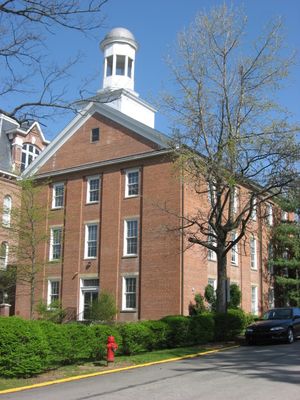
Enable Location

We need your location to show you interesting places around you

Discover nearby places

Find interesting locations and hidden gems around you

Precise directions

Get accurate directions and distances to places

Your location is never shared with other users. It's only used when you tap the location button.

Hanna Hall

Log in to your account

Start exploring — it's free

Trusted by 62,841 travelers worldwide

Continue with Google
Continue with Apple
or

We will send you a code to connect

By continuing, you accept our Terms and Conditions and our Privacy Policy

Check your inbox

We've sent a pincode in your inbox. Please enter the code below.

Hanna Hall

Hanna Hall is a three-story red brick building on the Waynesburg University campus featuring Federal-style architecture with simple lines and symmetry. The structure includes a wooden bell tower on its gabled roof and rectangular footprint positioned along College Street in the historic district.

The building was constructed in 1851 and initially served as dormitory space, classrooms, and later as a chapel for the college. It was added to the National Register of Historic Places in 1979, recognizing its importance to the region's educational heritage.

The building is named after Reverend William Hanna, a significant community figure whose support helped sustain the university. Students and alumni recall it as a place where learning and campus traditions came together over generations.

The building sits centrally on campus and is accessible from most areas, with College Street running nearby for easy orientation. Interior spaces are arranged functionally with classrooms and offices positioned for straightforward navigation.

A bell sits atop the roof that was hidden away for decades before students restored and displayed it in 2015. The bell once rang daily to mark time on campus and now serves as a reminder of student initiative and the building's long rhythms.

The community of curious travelers

AroundUs brings together thousands of curated places, local tips, and hidden gems, enriched daily by 60,000 contributors worldwide.

Start exploring
Location
GPS coordinates
39.89944,-80.18694
Latest update
February 9, 2026 07:44
Around this place
John Corbley Farm
United States of America

John Corbley Farm

16 km
Bailey Covered Bridge
United States of America

Bailey Covered Bridge

13.5 km
Miller Hall
United States of America

Miller Hall

95 m
Horn Davis Overholtzer Bridge
United States of America

Horn Davis Overholtzer Bridge

16.1 km
Day Covered Bridge
United States of America

Day Covered Bridge

17.1 km
White Covered Bridge
United States of America

White Covered Bridge

15.5 km
Charles Grant Heasley House
United States of America

Charles Grant Heasley House

1.1 km
Ulery Mill
United States of America

Ulery Mill

15.6 km
Martin's Mill Covered Bridge
United States of America

Martin's Mill Covered Bridge

13.6 km
Marianna Historic District
United States of America

Marianna Historic District

15.7 km
W. A. Young and Sons Foundry and Machine Shop
United States of America

W. A. Young and Sons Foundry and Machine Shop

17 km
Hughes Covered Bridge
United States of America

Hughes Covered Bridge

15 km
Hamilton-Ely Farmstead
United States of America

Hamilton-Ely Farmstead

6.9 km
Lippincott Covered Bridge
United States of America

Lippincott Covered Bridge

7.1 km
Bridge in Franklin Township
United States of America

Bridge in Franklin Township

896 m
Scott Covered Bridge
United States of America

Scott Covered Bridge

11.9 km
Greene Hills Farm
United States of America

Greene Hills Farm

5.4 km
William Cree House
United States of America

William Cree House

12.1 km
Grimes Covered Bridge
United States of America

Grimes Covered Bridge

6.5 km
George West Gordon Farm
United States of America

George West Gordon Farm

5.9 km
Shriver Covered Bridge
United States of America

Shriver Covered Bridge

9.5 km
Nettie Woods Covered Bridge
United States of America

Nettie Woods Covered Bridge

5.7 km
Waynesburg Historic District
United States of America

Waynesburg Historic District

247 m
Hughes House
United States of America

Hughes House

11.5 km
John Rex Farm
United States of America

John Rex Farm

11.5 km
Rice's Landing Historic District
United States of America

Rice's Landing Historic District

16.9 km
Thomas Kent, Jr., Farm
United States of America

Thomas Kent, Jr., Farm

3 km
Greene County Museum
United States of America

Greene County Museum

5.5 km
Show the full map
« Hanna Hall » is provided by Around Us (aroundus.com). Images and texts are derived from Wikimedia project under a Creative Commons license. You are allowed to copy, distribute, and modify copies of this page, under the conditions set by the license, as long as this note is clearly visible.

Discover hidden gems everywhere you go!

From secret cafés to breathtaking viewpoints, skip the crowded tourist spots and find places that match your style. Our app makes it easy with voice search, smart filtering, route optimization, and insider tips from travelers worldwide. Download now for the complete mobile experience.

Around Us App Screenshot

A unique approach to discovering new places

Le Figaro

All the places worth exploring

France Info

A tailor-made excursion in just a few clicks

20 Minutes

Around Us
Travel Guide & Maps
Download

Send to your phone

QR Code
1

Open the camera app on your mobile.

2

Point at the QR code with your camera. A notification will appear.

3

Tap the notification to open the link.