Enable Location

We need your location to show you interesting places around you

Discover nearby places

Find interesting locations and hidden gems around you

Precise directions

Get accurate directions and distances to places

Your location is never shared with other users. It's only used when you tap the location button.

Horn Davis Overholtzer Bridge

Log in to your account

Start exploring — it's free

Trusted by 62,846 travelers worldwide

Continue with Google
Continue with Apple
or

We will send you a code to connect

By continuing, you accept our Terms and Conditions and our Privacy Policy

Check your inbox

We've sent a pincode in your inbox. Please enter the code below.

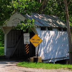
Horn Davis Overholtzer Bridge, overdekte brug in de Verenigde Staten

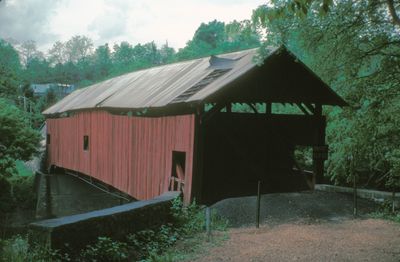
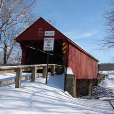
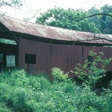
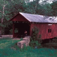
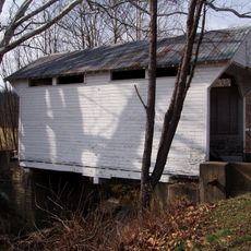
The Horn Davis Overholtzer Bridge is a small covered bridge in Pennsylvania constructed entirely of wood, with a roof protecting the entire roadway. The structure features visible wooden beams showing traditional 19th-century construction methods, and its narrow width accommodates only single-file traffic.

Built in 1889, the bridge dates to a period when covered structures protected wooden spans from weather damage across Pennsylvania. It belongs to a cohort of late-19th-century bridges in Washington County that reflect the regional construction practices of that era.

The bridge holds meaning for local residents as a marker of their rural heritage and everyday history. It remains woven into community memory through generations, representing the practical connections that once shaped daily life in this quiet Pennsylvania landscape.

The bridge is located in a rural setting southeast of Fairfield near North Fredericktown and is most easily accessed on foot or with small vehicles. The quiet country roads and narrow approach make it ideal for leisurely exploration without heavy traffic concerns.

The builders of this bridge remain unknown, yet its construction reveals skilled craftsmanship through carefully joined and reinforced wooden elements that have endured for generations. While some boards have been replaced over time, the overall structure and design have remained essentially unchanged.

The community of curious travelers

AroundUs brings together thousands of curated places, local tips, and hidden gems, enriched daily by 60,000 contributors worldwide.

Start exploring
Location
GPS coordinates
40.00806,-80.06250
Latest update
February 9, 2026 07:44
Around this place
Penn-Craft Historic District
United States of America

Penn-Craft Historic District

13.9 km
Beallsville Historic District
United States of America

Beallsville Historic District

7.2 km
Regester Log House
United States of America

Regester Log House

5.7 km
Bailey Covered Bridge
United States of America

Bailey Covered Bridge

11.5 km
Huffman Distillery and Chopping Mill
United States of America

Huffman Distillery and Chopping Mill

12.7 km
Scenery Hill Historic District
United States of America

Scenery Hill Historic District

8.7 km
Ulery Mill
United States of America

Ulery Mill

1.2 km
Centerville Historic District
United States of America

Centerville Historic District

8.4 km
Philip Friend House
United States of America

Philip Friend House

8.8 km
Martin's Mill Covered Bridge
United States of America

Martin's Mill Covered Bridge

5.9 km
Marianna Historic District
United States of America

Marianna Historic District

3.4 km
W. A. Young and Sons Foundry and Machine Shop
United States of America

W. A. Young and Sons Foundry and Machine Shop

8.5 km
Hughes Covered Bridge
United States of America

Hughes Covered Bridge

8.8 km
Greene Academy
United States of America

Greene Academy

14.1 km
Joseph Dorsey House
United States of America

Joseph Dorsey House

11.9 km
Welsh-Emery House
United States of America

Welsh-Emery House

7 km
Lippincott Covered Bridge
United States of America

Lippincott Covered Bridge

9 km
Kinder's Mill
United States of America

Kinder's Mill

2.6 km
Ringland Tavern
United States of America

Ringland Tavern

8.5 km
Harrison House
United States of America

Harrison House

9.9 km
William Cree House
United States of America

William Cree House

13.1 km
Grimes Covered Bridge
United States of America

Grimes Covered Bridge

10.2 km
Hughes House
United States of America

Hughes House

8.4 km
John Rex Farm
United States of America

John Rex Farm

8.4 km
Rice's Landing Historic District
United States of America

Rice's Landing Historic District

8.5 km
National Pike Steam Gas and Horse Association
United States of America

National Pike Steam Gas and Horse Association

11 km
Maxwell Lock & Dam
United States of America

Maxwell Lock & Dam

8.8 km
Cox Farm Covered Bridge
United States of America

Cox Farm Covered Bridge

9 km
Show the full map
« Horn Davis Overholtzer Bridge - overdekte brug in de Verenigde Staten » is provided by Around Us (aroundus.com). Images and texts are derived from Wikimedia project under a Creative Commons license. You are allowed to copy, distribute, and modify copies of this page, under the conditions set by the license, as long as this note is clearly visible.

Discover hidden gems everywhere you go!

From secret cafés to breathtaking viewpoints, skip the crowded tourist spots and find places that match your style. Our app makes it easy with voice search, smart filtering, route optimization, and insider tips from travelers worldwide. Download now for the complete mobile experience.

Around Us App Screenshot

A unique approach to discovering new places

Le Figaro

All the places worth exploring

France Info

A tailor-made excursion in just a few clicks

20 Minutes

Around Us
Travel Guide & Maps
Download

Send to your phone

QR Code
1

Open the camera app on your mobile.

2

Point at the QR code with your camera. A notification will appear.

3

Tap the notification to open the link.