Enable Location

We need your location to show you interesting places around you

Discover nearby places

Find interesting locations and hidden gems around you

Precise directions

Get accurate directions and distances to places

Your location is never shared with other users. It's only used when you tap the location button.

Miller Hall

Log in to your account

Start exploring — it's free

Trusted by 62,840 travelers worldwide

Continue with Google
Continue with Apple
or

We will send you a code to connect

By continuing, you accept our Terms and Conditions and our Privacy Policy

Check your inbox

We've sent a pincode in your inbox. Please enter the code below.

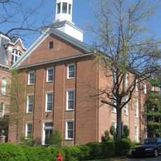
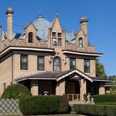
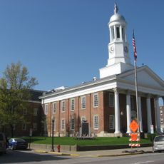
Miller Hall, Second Empire university building in Waynesburg, United States

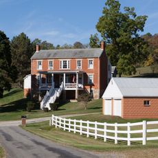
Miller Hall is a university building in Waynesburg, Pennsylvania, constructed in the Second Empire architectural style. The structure features prominent mansard roofs, ornamental brackets, and symmetrically arranged windows across all of its facades.

The building was erected in the 19th century as part of Waynesburg University's development and later received recognition on the National Register of Historic Places. This designation honors its contribution to institutional architecture in southwestern Pennsylvania.

The building serves as a focal point on campus where daily academic life unfolds, representing the institution's long commitment to education. Students and faculty move through its spaces as part of their regular routines.

The building is located at the heart of the university campus and can be viewed from outside to observe its architectural features. Daytime visits offer the best light for seeing the decorative details on all sides of the structure.

The structure preserves nearly all of its original Second Empire architectural elements, making it an uncommon example of unchanged design from that era. This allows visitors to see the stylistic details much as they appeared when first completed over a century ago.

The community of curious travelers

AroundUs brings together thousands of curated places, local tips, and hidden gems, enriched daily by 60,000 contributors worldwide.

Start exploring
Location
Architectural style
Second Empire style
GPS coordinates
39.89944,-80.18806
Latest update
December 14, 2025 18:47
Around this place
John Corbley Farm
United States of America

John Corbley Farm

16.1 km
Bailey Covered Bridge
United States of America

Bailey Covered Bridge

13.5 km
Hanna Hall
United States of America

Hanna Hall

95 m
Horn Davis Overholtzer Bridge
United States of America

Horn Davis Overholtzer Bridge

16.2 km
Day Covered Bridge
United States of America

Day Covered Bridge

17 km
White Covered Bridge
United States of America

White Covered Bridge

15.6 km
Charles Grant Heasley House
United States of America

Charles Grant Heasley House

1.1 km
Ulery Mill
United States of America

Ulery Mill

15.7 km
Martin's Mill Covered Bridge
United States of America

Martin's Mill Covered Bridge

13.6 km
Marianna Historic District
United States of America

Marianna Historic District

15.7 km
Hughes Covered Bridge
United States of America

Hughes Covered Bridge

15.1 km
Hamilton-Ely Farmstead
United States of America

Hamilton-Ely Farmstead

6.9 km
Lippincott Covered Bridge
United States of America

Lippincott Covered Bridge

7.2 km
Bridge in Franklin Township
United States of America

Bridge in Franklin Township

963 m
Scott Covered Bridge
United States of America

Scott Covered Bridge

11.8 km
Greene Hills Farm
United States of America

Greene Hills Farm

5.5 km
William Cree House
United States of America

William Cree House

12.2 km
Grimes Covered Bridge
United States of America

Grimes Covered Bridge

6.6 km
George West Gordon Farm
United States of America

George West Gordon Farm

6 km
Shriver Covered Bridge
United States of America

Shriver Covered Bridge

9.4 km
Nettie Woods Covered Bridge
United States of America

Nettie Woods Covered Bridge

5.7 km
Waynesburg Historic District
United States of America

Waynesburg Historic District

218 m
Hughes House
United States of America

Hughes House

11.5 km
John Rex Farm
United States of America

John Rex Farm

11.5 km
Rice's Landing Historic District
United States of America

Rice's Landing Historic District

17 km
Thomas Kent, Jr., Farm
United States of America

Thomas Kent, Jr., Farm

3.1 km
Greene County Museum
United States of America

Greene County Museum

5.6 km
Cox Farm Covered Bridge
United States of America

Cox Farm Covered Bridge

7.2 km
Show the full map
« Miller Hall - Second Empire university building in Waynesburg, United States » is provided by Around Us (aroundus.com). Images and texts are derived from Wikimedia project under a Creative Commons license. You are allowed to copy, distribute, and modify copies of this page, under the conditions set by the license, as long as this note is clearly visible.

Discover hidden gems everywhere you go!

From secret cafés to breathtaking viewpoints, skip the crowded tourist spots and find places that match your style. Our app makes it easy with voice search, smart filtering, route optimization, and insider tips from travelers worldwide. Download now for the complete mobile experience.

Around Us App Screenshot

A unique approach to discovering new places

Le Figaro

All the places worth exploring

France Info

A tailor-made excursion in just a few clicks

20 Minutes

Around Us
Travel Guide & Maps
Download

Send to your phone

QR Code
1

Open the camera app on your mobile.

2

Point at the QR code with your camera. A notification will appear.

3

Tap the notification to open the link.