Enable Location

We need your location to show you interesting places around you

Discover nearby places

Find interesting locations and hidden gems around you

Precise directions

Get accurate directions and distances to places

Your location is never shared with other users. It's only used when you tap the location button.

Log in to your account

Start exploring — it's free

Trusted by 62,464 travelers worldwide

Continue with Google
Continue with Apple
or

We will send you a code to connect

By continuing, you accept our Terms and Conditions and our Privacy Policy

Check your inbox

We've sent a pincode in your inbox. Please enter the code below.

Hayes site

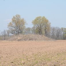
Hayes site, Archaeological site near Bayou Meto, Arkansas County, United States.

Hayes site is an archaeological settlement featuring four earthen mounds positioned around a central open plaza near Bayou Meto. The mounds vary in size and purpose, with the whole arrangement following the landscape of this river valley location.

The settlement was inhabited by the Plum Bayou culture from around 650 to 1050 CE, during the Late Woodland period of prehistoric America. The mounds were constructed and used during this era before the site was eventually abandoned.

The pottery and tools found here reveal how the Plum Bayou people lived daily and made their belongings. Visitors can examine these discoveries in regional museums to understand the craft and skill of this ancient culture.

This location is situated in a rural area of Arkansas County and welcomes those interested in ancient settlements. Research materials and detailed information about the site are available through the Arkansas Archeological Survey.

The arrangement of four mounds represents one of the earliest examples of a planned settlement layout in North America before European contact. This organization reveals sophisticated decision-making among the inhabitants about how to structure their community.

The community of curious travelers

AroundUs brings together thousands of curated places, local tips, and hidden gems, enriched daily by 60,000 contributors worldwide.

Start exploring
Location
GPS coordinates
34.44250,-91.60920
Latest update
December 14, 2025 17:40
Around this place
Coy Site
United States of America

Coy Site

28.4 km
De Valls Bluff Waterworks
United States of America

De Valls Bluff Waterworks

40.2 km
Highway 79 Bridge
United States of America

Highway 79 Bridge

38.4 km
Standard Ice Company Building
United States of America

Standard Ice Company Building

8.1 km
Monroe County Courthouse
United States of America

Monroe County Courthouse

38.8 km
Crocketts Bluff Hunting Lodge
United States of America

Crocketts Bluff Hunting Lodge

35.7 km
Bank of Clarendon
United States of America

Bank of Clarendon

38.8 km
Arkansas County Courthouse-Southern District
United States of America

Arkansas County Courthouse-Southern District

30.1 km
Sherrill Methodist Episcopal Church, South
United States of America

Sherrill Methodist Episcopal Church, South

32.1 km
Halliburton House
United States of America

Halliburton House

29.7 km
Cumberland Presbyterian Church
United States of America

Cumberland Presbyterian Church

39.1 km
North Jackson Street Bridge
United States of America

North Jackson Street Bridge

29.3 km
Arkansas County Courthouse-Northern District
United States of America

Arkansas County Courthouse-Northern District

8.3 km
Bateman-Griffith House
United States of America

Bateman-Griffith House

39.2 km
L.A. Black Rice Milling Association Inc. Office
United States of America

L.A. Black Rice Milling Association Inc. Office

29.9 km
North Washington Street Bridge
United States of America

North Washington Street Bridge

29.9 km
Wabbaseka Methodist Episcopal Church, South
United States of America

Wabbaseka Methodist Episcopal Church, South

19.6 km
Moore-Jacobs House
United States of America

Moore-Jacobs House

39.3 km
Immanuel High School
United States of America

Immanuel High School

26.8 km
First United Methodist Church
United States of America

First United Methodist Church

29.9 km
DeWitt Commercial Historic District
United States of America

DeWitt Commercial Historic District

30.1 km
Jefferies-Crabtree House
United States of America

Jefferies-Crabtree House

39.2 km
Maxwell Street Bridge
United States of America

Maxwell Street Bridge

29.7 km
Marston House
United States of America

Marston House

39.2 km
Roselawn
United States of America

Roselawn

27.5 km
Orth C. Galloway House
United States of America

Orth C. Galloway House

39.5 km
Tucker School
United States of America

Tucker School

31.8 km
Stuttgart Commercial Historic District
United States of America

Stuttgart Commercial Historic District

8.1 km
Show the full map
« Hayes site - Archaeological site near Bayou Meto, Arkansas County, United States » is provided by Around Us (aroundus.com). Images and texts are derived from Wikimedia project under a Creative Commons license. You are allowed to copy, distribute, and modify copies of this page, under the conditions set by the license, as long as this note is clearly visible.

Discover hidden gems everywhere you go!

From secret cafés to breathtaking viewpoints, skip the crowded tourist spots and find places that match your style. Our app makes it easy with voice search, smart filtering, route optimization, and insider tips from travelers worldwide. Download now for the complete mobile experience.

Around Us App Screenshot

A unique approach to discovering new places

Le Figaro

All the places worth exploring

France Info

A tailor-made excursion in just a few clicks

20 Minutes

Around Us
Travel Guide & Maps
Download

Send to your phone

QR Code
1

Open the camera app on your mobile.

2

Point at the QR code with your camera. A notification will appear.

3

Tap the notification to open the link.