·

Enable Location

We need your location to show you interesting places around you

Discover nearby places

Find interesting locations and hidden gems around you

Precise directions

Get accurate directions and distances to places

Your location is never shared with other users. It's only used when you tap the location button.

Hares Hill Road Bridge

Log in to your account

Start exploring — it's free

Trusted by 62,754 travelers worldwide

Continue with Google
Continue with Apple
or

We will send you a code to connect

By continuing, you accept our Terms and Conditions and our Privacy Policy

Check your inbox

We've sent a pincode in your inbox. Please enter the code below.

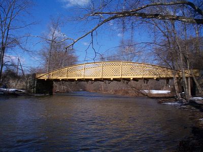
Hares Hill Road Bridge, Tied-arch bridge in Kimberton, United States

Hares Hill Road Bridge is a tied-arch bridge in Kimberton that crosses French Creek using a single wrought iron lattice girder structure. The construction measures 103 feet (31 m) in length and 14 feet (4 m) in width, connecting both banks with one continuous span.

The bridge was constructed in 1867 and opened in 1869, emerging during the post-Civil War infrastructure expansion in Chester County. It was among the first iron bridges built in the region during this period of development.

The bridge reflects Thomas W. H. Moseley's engineering approach and stands as the only surviving example of his wrought iron lattice girder design. His technical method did not become widespread in the region, making this structure a rare record of his work.

The bridge underwent rehabilitation in 2009 and 2010 with a new steel deck that accommodates both vehicles and bicycles safely. The structure was upgraded to handle increased load capacity while remaining open for public use.

It remains the sole iron highway bridge from its era still serving public transportation needs in Chester County. While many similar structures have disappeared, this one continues to fulfill its original purpose today.

The community of curious travelers

AroundUs brings together thousands of curated places, local tips, and hidden gems, enriched daily by 60,000 contributors worldwide.

Start exploring
Location
Inception
1867
Official opening
1869
GPS coordinates
40.14111,-75.56778
Latest update
December 14, 2025 18:12
Around this place
Schuylkill Canal
United States of America

Schuylkill Canal

5.6 km
Colonial Theatre
United States of America

Colonial Theatre

4.3 km
St. Basil the Great, Kimberton
United States of America

St. Basil the Great, Kimberton

1.2 km
White Horse Farm
United States of America

White Horse Farm

5.9 km
Vincent Forge Mansion
United States of America

Vincent Forge Mansion

6.5 km
Black Rock Bridge
United States of America

Black Rock Bridge

5.1 km
Moore Hall
United States of America

Moore Hall

6.5 km
Mont Clare Bridge
United States of America

Mont Clare Bridge

5.1 km
Rapps Bridge
United States of America

Rapps Bridge

1.3 km
Strickland-Roberts Homestead
United States of America

Strickland-Roberts Homestead

6.1 km
Continental Stove Works
United States of America

Continental Stove Works

5.2 km
Moses Coates Jr. Farm
United States of America

Moses Coates Jr. Farm

4.7 km
Hall's Bridge
United States of America

Hall's Bridge

4.6 km
Kennedy Bridge
United States of America

Kennedy Bridge

765 m
Oskar G. Stonorov House
United States of America

Oskar G. Stonorov House

4.6 km
Charlestown Village Historic District
United States of America

Charlestown Village Historic District

4.7 km
French Creek Farm
United States of America

French Creek Farm

1.7 km
Kimberton Historic District
United States of America

Kimberton Historic District

1.5 km
Birchrunville General Store
United States of America

Birchrunville General Store

6.3 km
George Hartman House
United States of America

George Hartman House

4.7 km
Deery Family Homestead
United States of America

Deery Family Homestead

4.7 km
Middle Pickering Rural Historic District
United States of America

Middle Pickering Rural Historic District

5.3 km
Matthias Pennypacker Farm
United States of America

Matthias Pennypacker Farm

6.2 km
John Williams Farm
United States of America

John Williams Farm

6.1 km
Prizer's Mill Complex
United States of America

Prizer's Mill Complex

658 m
Martin-Little House
United States of America

Martin-Little House

6.3 km
Fagley House
United States of America

Fagley House

5.3 km
Birchrunville Historic District
United States of America

Birchrunville Historic District

6.1 km
Show the full map
« Hares Hill Road Bridge - Tied-arch bridge in Kimberton, United States » is provided by Around Us (aroundus.com). Images and texts are derived from Wikimedia project under a Creative Commons license. You are allowed to copy, distribute, and modify copies of this page, under the conditions set by the license, as long as this note is clearly visible.

Discover hidden gems everywhere you go!

From secret cafés to breathtaking viewpoints, skip the crowded tourist spots and find places that match your style. Our app makes it easy with voice search, smart filtering, route optimization, and insider tips from travelers worldwide. Download now for the complete mobile experience.

Around Us App Screenshot

A unique approach to discovering new places

Le Figaro

All the places worth exploring

France Info

A tailor-made excursion in just a few clicks

20 Minutes

Around Us
Travel Guide & Maps
Download

Send to your phone

QR Code
1

Open the camera app on your mobile.

2

Point at the QR code with your camera. A notification will appear.

3

Tap the notification to open the link.